1900s (20th Century) Maps of Brady Township, Pennsylvania
Explore 27 historic maps of Brady Township from the 1900s (20th Century). These maps offer a rare glimpse into what life looked like during the 1900s — showing old roads, neighborhoods, homes, and landmarks that have changed or disappeared over time.
Whether you're researching your family's past, planning a metal detecting trip, or studying how Brady Township's landscape evolved across the 1900s, these high-resolution maps are a powerful tool for exploring the history of this region.
- Focus on a specific era: All maps on this page are from the 1900s, giving you a focused view of this time period.
- See what’s changed: Compare century-old streets, trails, and buildings to today's modern landscape using overlays and satellite layers.
- Research with precision: Use these maps for genealogy, historical research, land use analysis, or educational projects.
- View, download, or print: Maps are fully viewable online in high resolution, and can be downloaded or printed for your own records.
Start exploring Brady Township's history through authentic maps from the 1900s. This is your window into the past.
Brady Township, PA maps
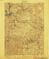
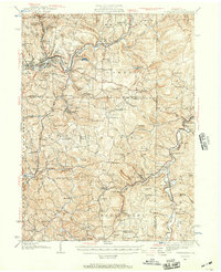
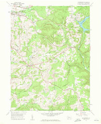
(27)- 1903 Map of Curwensville
 1903 Curwensville1903 Print · USGSCovers Brady Township, including Curwensville, Beccaria Township, and other nearby areas4 unique versions available
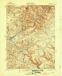
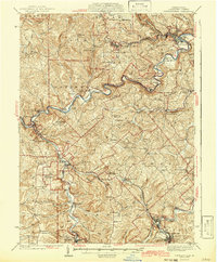
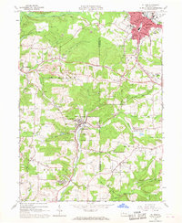
 - 1906 Map of Punxsutawney
 1906 Punxsutawney1906 Print · USGSCovers Brady Township, including Punxsutawney, Winslow, and other nearby areas4 unique versions available
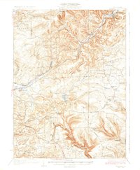
 - 1922 Map of Du Bois, 1957 Print
 1922 Du Bois1957 Print · USGSCovers Brady Township, including Sandy Township, DuBois, and other nearby areas2 unique versions available
 - 1924 Map of Du Bois
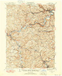
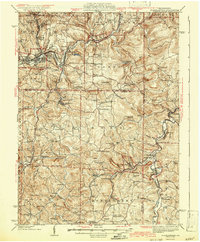
 1924 Du Bois1924 Print · USGSCovers Brady Township, including Sandy Township, DuBois, and other nearby areas5 unique versions available
 - 1929 Map of Penfield, 1954 Print
 1929 Penfield1954 Print · USGSCovers Brady Township, including Sandy Township, DuBois, and other nearby areas3 unique versions available
 - 1932 Map of Penfield
 1932 Penfield1932 Print · USGSCovers Brady Township, including Sandy Township, DuBois, and other nearby areas3 unique versions available
 - 1939 Map of Curwensville, 1952 Print
 1939 Curwensville1952 Print · USGSCovers Brady Township, including Curwensville, Beccaria Township, and other nearby areas2 unique versions available
 - 1939 Map of Punxsutawney, 1957 Print
 1939 Punxsutawney1957 Print · USGSCovers Brady Township, including Punxsutawney, Winslow, and other nearby areas2 unique versions available
 - 1942 Map of Curwensville
 1942 Curwensville1942 Print · USGSCovers Brady Township, including Curwensville, Beccaria Township, and other nearby areas
 - 1942 Map of Punxsutawney
 1942 Punxsutawney1942 Print · USGSCovers Brady Township, including Punxsutawney, Winslow, and other nearby areas2 unique versions available
 - 1943 Map of Punxsutawney
 1943 Punxsutawney1943 Print · USGSCovers Brady Township, including Punxsutawney, Northern Cambria, and other nearby areas
 - 1944 Map of Du Bois
 1944 Du Bois1944 Print · USGSCovers Brady Township, including Sandy Township, DuBois, and other nearby areas
 - 1953 Map of Pittsburgh
 1953 Pittsburgh1953 Print · USGSCovers Brady Township, including Pittsburgh, Penn Hills, and other nearby areas
 - 1954 Map of Pittsburgh
 1954 Pittsburgh1954 Print · USGSCovers Brady Township, including Pittsburgh, Penn Hills, and other nearby areas2 unique versions available
 - 1957 Map of Warren, 1964 Print
 1957 Warren1964 Print · USGSCovers Brady Township, including Saint Marys, Sandy Township, and other nearby areas4 unique versions available
 - 1958 Map of Pittsburgh
 1958 Pittsburgh1958 Print · USGSCovers Brady Township, including Pittsburgh, Penn Hills, and other nearby areas5 unique versions available
 - 1958 Map of Warren
 1958 Warren1958 Print · USGSCovers Brady Township, including Saint Marys, Sandy Township, and other nearby areas
 - 1959 Map of Warren
 1959 Warren1959 Print · USGSCovers Brady Township, including Saint Marys, Sandy Township, and other nearby areas2 unique versions available
 - 1959 Map of Pittsburgh
 1959 Pittsburgh1959 Print · USGSCovers Brady Township, including Pittsburgh, Penn Hills, and other nearby areas
 - 1959 Map of Mahaffey, 1960 Print
 1959 Mahaffey1960 Print · USGSCovers Brady Township, including Bloom Township, Irishtown, and other nearby areas6 unique versions available
 - 1959 Map of Luthersburg, 1960 Print
 1959 Luthersburg1960 Print · USGSCovers Brady Township, including Sandy Township, DuBois, and other nearby areas5 unique versions available
 - 1964 Map of Pittsburgh
 1964 Pittsburgh1964 Print · USGSCovers Brady Township, including Pittsburgh, Penn Hills, and other nearby areas
 - 1966 Map of Du Bois, 1968 Print
 1966 Du Bois1968 Print · USGSCovers Brady Township, including Sandy Township, DuBois, and other nearby areas6 unique versions available
 - 1968 Map of Mc Gees Mills, 1971 Print
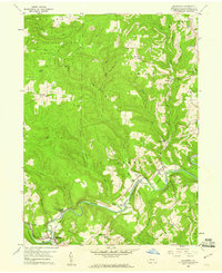
 1968 Mc Gees Mills1971 Print · USGSCovers Brady Township, including Gaskill Township, Banks Township, and other nearby areas5 unique versions available
 - 1971 Map of Warren
 1971 Warren1971 Print · USGSCovers Brady Township, including Saint Marys, Sandy Township, and other nearby areas
Showing maps 1-25 of 27
Top cities near Brady Township
- Sandy Township historical maps
- DuBois historical maps
- Winslow historical maps
- Reynoldsville historical maps
- Curwensville historical maps
- Brockway historical maps
See more
Top neighborhoods of Brady Township
Frequently asked questions
- What are the different types of historical maps available for Brady Township?
- What is the oldest map of Brady Township?
- Where can I purchase historical maps of Brady Township for my home or office?
- Where can I download high-res historical maps of Brady Township?
- Are there historical topographic maps available for Brady Township?
- Is there historical aerial imagery available for Brady Township?
- Where are historical maps of Brady Township sourced from?