1990s Maps of Woodward Township, Pennsylvania
Explore 3 historic maps of Woodward Township from the 1990s. These maps offer a rare glimpse into what life looked like during the 1990s — showing old roads, neighborhoods, homes, and landmarks that have changed or disappeared over time.
Whether you're researching your family's past, planning a metal detecting trip, or studying how Woodward Township's landscape evolved across the 1990s, these high-resolution maps are a powerful tool for exploring the history of this region.
- Focus on a specific era: All maps on this page are from the 1990s, giving you a focused view of this time period.
- See what’s changed: Compare century-old streets, trails, and buildings to today's modern landscape using overlays and satellite layers.
- Research with precision: Use these maps for genealogy, historical research, land use analysis, or educational projects.
- View, download, or print: Maps are fully viewable online in high resolution, and can be downloaded or printed for your own records.
Start exploring Woodward Township's history through authentic maps from the 1990s. This is your window into the past.
Woodward Township, PA maps
(3)- 1993 Map of Glen Richey, 1994 Print
 1993 Glen Richey1994 Print · USGSClearfield County in the early 1990s reveals a landscape shaped by coal mining and winding river valleys. Genealogists and local historians can trace family connections through sites like Thompson Cem, the Mt Zion Ch, and the settlement at Glen Richey.
 - 1993 Map of Houtzdale, 1994 Print
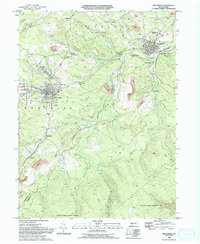 1993 Houtzdale1994 Print · USGSThe coal and rail corridors of Clearfield County are shown in great detail during the early nineties, centered on the historic borough of Houtzdale. Researchers can trace the layout of traditional mining settlements like Osceola Mills and Earnestville or locate family sites at St Joseph Cem.2 unique versions available
 - 1993 Map of Ramey, 1994 Print
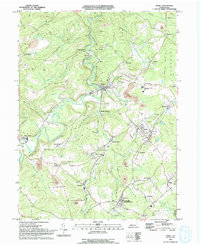 1993 Ramey1994 Print · USGSClearfield County's coal country is captured here in the early nineties, showing a landscape defined by industry and valley hamlets. Researchers can trace family roots at Janesville, Hegarty Crossroads, and the St Marys Cem.
End of results
Showing maps 1-3 of 3
Top cities near Woodward Township
- Clearfield historical maps
- Tyrone historical maps
- Philipsburg historical maps
- Curwensville historical maps
- Beccaria Township historical maps
- Warriors Mark Township historical maps
See more
Top neighborhoods of Woodward Township
- Whiteside historical maps
- Henderson historical maps
- Kendrick historical maps
- Faunce historical maps
- Sanborn historical maps
- Goss Run Junction historical maps
See more
Frequently asked questions
- What are the different types of historical maps available for Woodward Township?
- What is the oldest map of Woodward Township?
- Where can I purchase historical maps of Woodward Township for my home or office?
- Where can I download high-res historical maps of Woodward Township?
- Are there historical topographic maps available for Woodward Township?
- Is there historical aerial imagery available for Woodward Township?
- Where are historical maps of Woodward Township sourced from?