1940s Maps of Grugan Township, Pennsylvania
Explore 8 historic maps of Grugan Township from the 1940s. These maps offer a rare glimpse into what life looked like during the 1940s — showing old roads, neighborhoods, homes, and landmarks that have changed or disappeared over time.
Whether you're researching your family's past, planning a metal detecting trip, or studying how Grugan Township's landscape evolved across the 1940s, these high-resolution maps are a powerful tool for exploring the history of this region.
- Focus on a specific era: All maps on this page are from the 1940s, giving you a focused view of this time period.
- See what’s changed: Compare century-old streets, trails, and buildings to today's modern landscape using overlays and satellite layers.
- Research with precision: Use these maps for genealogy, historical research, land use analysis, or educational projects.
- View, download, or print: Maps are fully viewable online in high resolution, and can be downloaded or printed for your own records.
Start exploring Grugan Township's history through authentic maps from the 1940s. This is your window into the past.
Grugan Township, PA maps
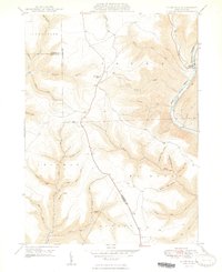
(8)- 1943 Map of Hyner
 1943 Hyner1943 Print · USGSIn the central Pennsylvania highlands during the mid-1940s, the river and rail lines dictated the life of the valley. Researchers can trace the industrial corridor from Renovo Boro to remote outposts like Slate Run and Young Womanstown.
 - 1946 Map of Renovo East, 1953 Print
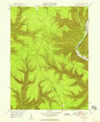
 1946 Renovo East1953 Print · USGSThe industrial corridor of the West Branch Susquehanna River is seen here in the mid-1940s, showing the critical rail infrastructure of the Pennsylvania railroad. Genealogists can trace family sites in Gleasonton or Farwell and locate the St Josephs Cem.3 unique versions available
 - 1946 Map of Slate Run, 1958 Print
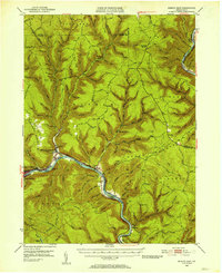
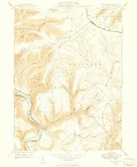
 1946 Slate Run1958 Print · USGSThe wilderness of Lycoming and Clinton counties comes into focus in the mid-1940s, highlighting the riverside rail economy and high-plateau landmarks. Genealogists and researchers can trace the New York Central railroad, the Slate Run settlement, and the Pump Station Fire Tower.4 unique versions available
 - 1946 Map of Renovo East, 1958 Print
 1946 Renovo East1958 Print · USGSThe West Branch Susquehanna River valley near Renovo is seen here just after the war, showing the industrial pulse of the river and rail lines. Genealogists and historians can locate Fairview Cem, the St Josephs Ch, and old settlements like Gleasonton and Farwell.4 unique versions available
 - 1946 Map of Glen Union, 1964 Print
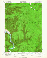 1946 Glen Union1964 Print · USGSThe West Branch Susquehanna River valley in the mid-1940s reveals a landscape of isolated river settlements and steep timbered hollows. Genealogists and historians can trace the early footprints of Glen Union, Whetham, and the Whetham Fire Tower along the river's winding course.5 unique versions available
 - 1948 Map of Renovo East
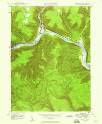
 1948 Renovo East1948 Print · USGSClinton County in the late 1940s centers on the busy river corridor of the West Branch Susquehanna River and its mountain settlements. Genealogists and rail historians can trace the Pennsylvania RR through Renovo, find resting places at St Josephs Cem, and locate the Hyner Landing Field.
 - 1948 Map of Slate Run
 1948 Slate Run1948 Print · USGSThe Pine Creek Valley near the Lycoming and Clinton county line is shown here just after the war, when the New York Central railroad still served the riverside. Genealogists and hikers can trace the remote hollows and high points like the Pump Station Fire Tower and the Gorge near Slate Run.2 unique versions available
 - 1948 Map of Glen Union
 1948 Glen Union1948 Print · USGSClinton County's river valley and high plateau country are shown in detail here just after the war. Local researchers can locate isolated river settlements like Whetham and Glen Union or trace the winding path of the Bucktail Trail and the Whetham Fire Tower.2 unique versions available
End of results
Showing maps 1-8 of 8
Top cities near Grugan Township
- Lock Haven historical maps
- Mill Hall historical maps
- Flemington historical maps
- Castanea Township historical maps
- Beech Creek historical maps
- South Renovo historical maps
See more
Top neighborhoods of Grugan Township
- Eagleton Fields historical maps
- Glen Union historical maps
- Ritchie historical maps
- Whetham historical maps
- Ferney historical maps
Frequently asked questions
- What are the different types of historical maps available for Grugan Township?
- What is the oldest map of Grugan Township?
- Where can I purchase historical maps of Grugan Township for my home or office?
- Where can I download high-res historical maps of Grugan Township?
- Are there historical topographic maps available for Grugan Township?
- Is there historical aerial imagery available for Grugan Township?
- Where are historical maps of Grugan Township sourced from?