1940s Maps of Hemlock Township, Pennsylvania
Explore 3 historic maps of Hemlock Township from the 1940s. These maps offer a rare glimpse into what life looked like during the 1940s — showing old roads, neighborhoods, homes, and landmarks that have changed or disappeared over time.
Whether you're researching your family's past, planning a metal detecting trip, or studying how Hemlock Township's landscape evolved across the 1940s, these high-resolution maps are a powerful tool for exploring the history of this region.
- Focus on a specific era: All maps on this page are from the 1940s, giving you a focused view of this time period.
- See what’s changed: Compare century-old streets, trails, and buildings to today's modern landscape using overlays and satellite layers.
- Research with precision: Use these maps for genealogy, historical research, land use analysis, or educational projects.
- View, download, or print: Maps are fully viewable online in high resolution, and can be downloaded or printed for your own records.
Start exploring Hemlock Township's history through authentic maps from the 1940s. This is your window into the past.
Hemlock Township, PA maps
(3)- 1943 Map of Shamokin
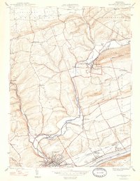
 1943 Shamokin1943 Print · USGSNorthumberland and Montour Counties were hubs of industry and river trade in the 1940s. Genealogists and historians can trace rail-era landmarks like Wolverton Station and coal-country staples such as the Trevorton Colliery and Zion Church.
 - 1947 Map of Bloomsburg
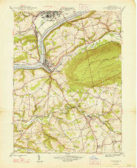
 1947 Bloomsburg1947 Print · USGSColumbia County at the dawn of the postwar era reveals a bustling river valley centered on Bloomsburg. Researchers can trace the legacy of the State Teachers College, local industry at the Paper Mill, and rural sites like Hidlay Ch.2 unique versions available
 - 1947 Map of Catawissa
 1947 Catawissa1947 Print · USGSColumbia County at the dawn of the post-war era reveals a bustling river valley shaped by coal-hauling railroads and rural industry. Genealogists can trace family names at Parrs Mill, Mt Zion Cem, and many local schools like Clayton Sch.2 unique versions available
End of results
Showing maps 1-3 of 3
Top cities near Hemlock Township
- Bloomsburg historical maps
- Elysburg historical maps
- Greenwood Township historical maps
- North Centre Township historical maps
- Riverside historical maps
- Moreland Township historical maps
See more
Top neighborhoods of Hemlock Township
Frequently asked questions
- What are the different types of historical maps available for Hemlock Township?
- What is the oldest map of Hemlock Township?
- Where can I purchase historical maps of Hemlock Township for my home or office?
- Where can I download high-res historical maps of Hemlock Township?
- Are there historical topographic maps available for Hemlock Township?
- Is there historical aerial imagery available for Hemlock Township?
- Where are historical maps of Hemlock Township sourced from?