1960s Maps of Rome Township, Pennsylvania
Explore 6 historic maps of Rome Township from the 1960s. These maps offer a rare glimpse into what life looked like during the 1960s — showing old roads, neighborhoods, homes, and landmarks that have changed or disappeared over time.
Whether you're researching your family's past, planning a metal detecting trip, or studying how Rome Township's landscape evolved across the 1960s, these high-resolution maps are a powerful tool for exploring the history of this region.
- Focus on a specific era: All maps on this page are from the 1960s, giving you a focused view of this time period.
- See what’s changed: Compare century-old streets, trails, and buildings to today's modern landscape using overlays and satellite layers.
- Research with precision: Use these maps for genealogy, historical research, land use analysis, or educational projects.
- View, download, or print: Maps are fully viewable online in high resolution, and can be downloaded or printed for your own records.
Start exploring Rome Township's history through authentic maps from the 1960s. This is your window into the past.
Rome Township, PA maps
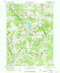
(6)- 1967 Map of Lake Canadohta, 1972 Print
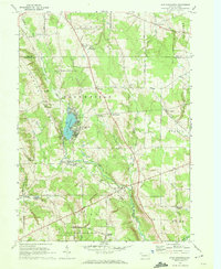 1967 Lake Canadohta1972 Print · USGSCrawford County recreation and rural life meet in the late sixties, centered on the developed shores of Lake Canadohta. Researchers can trace old transportation routes like the Old West Railroad Grade or locate family sites at the Bloomfield Burying Ground and Riceville.3 unique versions available
 - 1967 Map of Centerville, 1972 Print
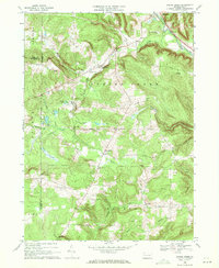
 1967 Centerville1972 Print · USGSCrawford County in the late sixties reveals a network of rural hamlets and farming crossroads at a moment of transition. Researchers can trace family history through numerous named landmarks like Markley Corners, Troy Center, and East Troy Cem.2 unique versions available
 - 1968 Map of Grand Valley, 1971 Print
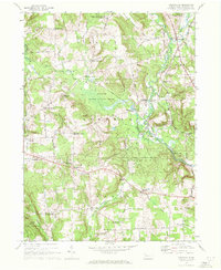
 1968 Grand Valley1971 Print · USGSThe oil-rich highlands of Warren and Crawford counties are documented here in the late sixties. Researchers can trace the petroleum-driven economy through numerous Oil Wells and the OIL FIELD, while locating family sites at Maultby Cem and Excelsior Ch.3 unique versions available
 - 1968 Map of Titusville North, 1971 Print
 1968 Titusville North1971 Print · USGSCrawford County's oil-rich countryside and the northern limits of Titusville are captured here in the late sixties. Genealogists and historians can trace family-named sites like Gilson Ridge Cemetery, Thompsons Mills, and numerous Oil Wells scattered across the ridges.2 unique versions available
 - 1968 Map of Spartansburg, 1971 Print
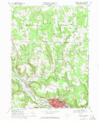
 1968 Spartansburg1971 Print · USGSThe rural landscape of Crawford County in the late sixties reveals a network of small settlements and rail corridors. Trace family roots and local industry through Blakeslee Corners, the Penn Central railroad, and Rose Hill Cem.4 unique versions available
 - 1968 Map of Spring Creek, 1971 Print
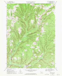
 1968 Spring Creek1971 Print · USGSNorthwestern Pennsylvania's rural landscape is captured here in the late sixties, showing the transition from rail-side villages to upland oil fields. Genealogists and historians can locate Spring Creek Sch, the Trimm Cem, and several Oil Wells near Sanford.3 unique versions available
End of results
Showing maps 1-6 of 6
Top cities near Rome Township
- Corry historical maps
- Titusville historical maps
- Union City historical maps
- Columbus historical maps
- Cherrytree Township historical maps
- Pittsfield Township historical maps
See more
Top neighborhoods of Rome Township
- Cloverdale Corners historical maps
- Rendalls Corners historical maps
- Vrooman historical maps
- Buell Corners historical maps
- Brimstone Corners historical maps
- McLaughlin Corners historical maps
Frequently asked questions
- What are the different types of historical maps available for Rome Township?
- What is the oldest map of Rome Township?
- Where can I purchase historical maps of Rome Township for my home or office?
- Where can I download high-res historical maps of Rome Township?
- Are there historical topographic maps available for Rome Township?
- Is there historical aerial imagery available for Rome Township?
- Where are historical maps of Rome Township sourced from?