1940s Maps of Lower Mifflin Township, Pennsylvania
Explore 3 historic maps of Lower Mifflin Township from the 1940s. These maps offer a rare glimpse into what life looked like during the 1940s — showing old roads, neighborhoods, homes, and landmarks that have changed or disappeared over time.
Whether you're researching your family's past, planning a metal detecting trip, or studying how Lower Mifflin Township's landscape evolved across the 1940s, these high-resolution maps are a powerful tool for exploring the history of this region.
- Focus on a specific era: All maps on this page are from the 1940s, giving you a focused view of this time period.
- See what’s changed: Compare century-old streets, trails, and buildings to today's modern landscape using overlays and satellite layers.
- Research with precision: Use these maps for genealogy, historical research, land use analysis, or educational projects.
- View, download, or print: Maps are fully viewable online in high resolution, and can be downloaded or printed for your own records.
Start exploring Lower Mifflin Township's history through authentic maps from the 1940s. This is your window into the past.
Lower Mifflin Township, PA maps
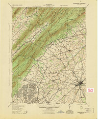
(3)- 1943 Map of Shippensburg, 1965 Print
 1943 Shippensburg1965 Print · USGSCumberland and Franklin Counties are captured here during the Second World War as modern infrastructure began to pierce the ridges. Researchers can trace family roots through dozens of rural landmarks like State Normal Sch, Orrstown, and the Union Ch.
 - 1945 Map of Newville
 1945 Newville1945 Print · USGSCumberland County at the end of the war shows a landscape where the new turnpike crosses a valley of established farms and mills. Researchers can trace family-named sites like Elliotts Mill, the Greythorne Walnut Bottom PO, and schools like Bluehill Sch.
 - 1945 Map of Shippensburg
 1945 Shippensburg1945 Print · USGSCumberland and Franklin counties meet at the base of the ridges in the mid-1940s, just as modern infrastructure begins to reshape the valley. Genealogists and historians can trace numerous rural schoolhouses like Clay Hill Sch and early infrastructure like the Kittatinny Tunnel and State Normal Sch.
End of results
Showing maps 1-3 of 3
Top cities near Lower Mifflin Township
- Carlisle historical maps
- Shippensburg historical maps
- Dickinson historical maps
- Saville Township historical maps
- Centre historical maps
- Lurgan Township historical maps
See more
Top neighborhoods of Lower Mifflin Township
Frequently asked questions
- What are the different types of historical maps available for Lower Mifflin Township?
- What is the oldest map of Lower Mifflin Township?
- Where can I purchase historical maps of Lower Mifflin Township for my home or office?
- Where can I download high-res historical maps of Lower Mifflin Township?
- Are there historical topographic maps available for Lower Mifflin Township?
- Is there historical aerial imagery available for Lower Mifflin Township?
- Where are historical maps of Lower Mifflin Township sourced from?