Old Maps of Cumberland County, Pennsylvania for Metal Detecting
Plan your next treasure hunt with 92 historic maps of Cumberland County. Find old homesites, ghost towns, trails, and gathering spots that may be lost to time — perfect for identifying promising metal detecting locations.
- Locate forgotten sites: Uncover places like long-lost settlements, abandoned rail lines, or gathering spots.
- Plan better hunts: Use map overlays combined with LiDAR or satellite views to narrow in on historically rich areas.
- Made for detectorists: Thousands of hobbyists use these maps to discover relics, coins, and hidden history.
Use these historic maps to boost your research and find new opportunities beneath the surface of Cumberland County.
Cumberland County, PA maps
(92)- 1892 Map of Harrisburg
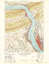
 1892 Harrisburg1892 Print · USGSThe Pennsylvania capital and the Susquehanna River corridor are captured here in the 1890s, revealing a landscape of mountain gaps and canal-era infrastructure. Genealogists can trace family roots through settlements like Wormleysburg, Linglestown, and the grounds of the State Lunatic Asylum.2 unique versions available
 - 1899 Map of Harrisburg
 1899 Harrisburg1899 Print · USGSHarrisburg and the Susquehanna River valley are captured here in the 1890s as the railroad era reached its height alongside older waterways. Genealogists and historians can trace the paths of the Pennsylvania Canal and find local landmarks like Heckton Mills and the State Lunatic Asylum.15 unique versions available
 - 1904 Map of Carlisle
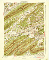
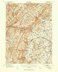
 1904 Carlisle1904 Print · USGSCumberland County at the opening of the century is a network of thriving rail hubs and rural gaps. Genealogists and historians can trace the foundations of Carlisle, find the grounds of the Carlisle Indian School, and locate rural landmarks like Salem Church and Boiling Springs.7 unique versions available
 - 1906 Map of New Cumberland
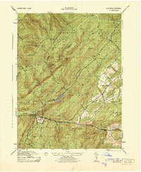
 1906 New Cumberland1906 Print · USGSCentral Pennsylvania at the opening of the twentieth century shows a landscape transitioning from canal-era transit to a heavy rail and industrial economy. Genealogists can locate family landmarks like Shafer Schoolhouse, Salem Church, and the Middletown Ferry.8 unique versions available
 - 1907 Map of New Bloomfield
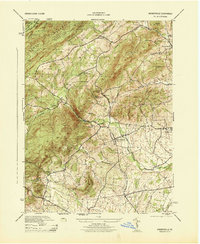
 1907 New Bloomfield1907 Print · USGSPerry County at the start of the twentieth century was a landscape of steep ridges and vital river junctions. Genealogists and historians can trace family locations in settlements like New Bloomfield or locate early industrial sites such as Juniata Furnace and Cove Forge.6 unique versions available
 - 1909 Map of Fairfield
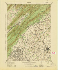
 1909 Fairfield1909 Print · USGSAdams County at the turn of the century shows a landscape of mountain sanitaria, early iron works, and a dense network of country schoolhouses. Genealogists and researchers can trace the old Western Maryland Railroad route and locate landmarks like Maria Furnace, Cashtown, and the South Mountain Sanatorium.6 unique versions available
 - 1919 Map of Newville
 1919 Newville1919 Print · USGSCumberland County life in the late teens centers on the rail corridors and water mills between the mountains. Trace family roots at Newville or Pine Grove Furnace, and locate rural landmarks like Reiters Mill and Miller Church.6 unique versions available
 - 1923 Map of Shippensburg
 1923 Shippensburg1923 Print · USGSShippensburg and its surrounding valley floor were defined by the rail lines and agricultural networks of the early twentieth century. Genealogists can locate dozens of country schools and churches, including Brookside School, Lurgan Sta, and the State Normal School campus.3 unique versions available
 - 1924 Map of Harrisburg
 1924 Harrisburg1924 Print · USGSThe Susquehanna River corridor at the state capital reveals a landscape of industrial river gaps and ridge-line valleys in the 1920s. Genealogists and historians can trace the paths of the Pennsylvania Canal and find landmarks like the State Lunatic Asylum and Fort Hunter.
 - 1930 Map of Loysville, 1953 Print
 1930 Loysville1953 Print · USGSPerry County's rural heartland is meticulously detailed in the 1930s, showing a landscape of ridge-and-valley farms and forest camps. Genealogists can trace family roots through numerous local landmarks like St Paul Ch, Academia Sch, and Loysville.
 - 1933 Map of Loysville
 1933 Loysville1933 Print · USGSPerry County's rural heartland is shown in detail during the early 1930s, when isolated valleys were still dotted with one-room schoolhouses and family farms. Genealogists can trace family footprints through sites like Fort Robinson, Cisna Run, and the numerous local schools like Oak Grove Sch.3 unique versions available
 - 1942 Map of Gettysburg, 1944 Print
 1942 Gettysburg1944 Print · USGSGettysburg and its surrounding borderlands are shown in great detail during the early 1940s, capturing the region's dense network of rural schools and mills. Genealogists can trace family-named landmarks such as Galt Kump PO, Hafers Mill, and Philips Delight Sch.
 - 1943 Map of New Cumberland
 1943 New Cumberland1943 Print · USGSGreater Harrisburg and the lower Susquehanna valley appear here in the midst of the Second World War, showing a landscape of intense military and social transition. Researchers can trace family roots through numerous country landmarks like Eberlys Mill, the Methodist Orphanage, and Messiah Bible College.
 - 1943 Map of Harrisburg
 1943 Harrisburg1943 Print · USGSThe Pennsylvania capital and its surrounding Susquehanna riverfront are seen here during the war years. Researchers can trace the extensive rail networks and find local landmarks like Fort Hunter, Good Hope Mills, and Wenrichs Ch.3 unique versions available
 - 1943 Map of New Bloomfield
 1943 New Bloomfield1943 Print · USGSPerry County's ridge-and-valley landscape is captured here during the Second World War as the rail-and-river corridor remained vital to the region. Genealogists can locate family landmarks like Hustons Mill, Mecks Corner, and the old Wila P O post office.
 - 1943 Map of Carlisle, 1944 Print
 1943 Carlisle1944 Print · USGSCumberland County during the mid-forties reveals a landscape transitioning between its deep industrial roots and new high-speed transit. Genealogists and historians can trace family locations through numerous rural landmarks like Farmers Academy, Reading Banks, and the Carlisle Barracks.3 unique versions available
 - 1943 Map of Shippensburg, 1965 Print
 1943 Shippensburg1965 Print · USGSCumberland and Franklin Counties are captured here during the Second World War as modern infrastructure began to pierce the ridges. Researchers can trace family roots through dozens of rural landmarks like State Normal Sch, Orrstown, and the Union Ch.
 - 1944 Map of Flat Ridge
 1944 Flat Ridge1944 Print · USGSThe South Mountain high country in the mid-1940s is defined by vast state forests and conservation lands. Hikers and historians can trace the Appalachian Trail past Caledonia Park, Strasbaugh School, and the Chambersburg Reservoir.6 unique versions available
 - 1944 Map of Arendtsville
 1944 Arendtsville1944 Print · USGSAdams County orchard country and the eastern slopes of South Mountain are captured here during the mid-1940s. Genealogists and local historians can locate several rural schoolhouses, including Shellys School, and old mill sites like Genoltz Mill near Arendtsville.7 unique versions available
 - 1945 Map of Newville
 1945 Newville1945 Print · USGSCumberland County at the end of the war shows a landscape where the new turnpike crosses a valley of established farms and mills. Researchers can trace family-named sites like Elliotts Mill, the Greythorne Walnut Bottom PO, and schools like Bluehill Sch.
 - 1945 Map of Shippensburg
 1945 Shippensburg1945 Print · USGSCumberland and Franklin counties meet at the base of the ridges in the mid-1940s, just as modern infrastructure begins to reshape the valley. Genealogists and historians can trace numerous rural schoolhouses like Clay Hill Sch and early infrastructure like the Kittatinny Tunnel and State Normal Sch.
 - 1947 Map of Harrisburg West
 1947 Harrisburg West1947 Print · USGSThe Susquehanna River corridor near Harrisburg is captured here just after the war, showing the massive rail infrastructure and mountain gaps that define the region. Genealogists and local historians can locate the Enola yards, Good Hope Mills, and family burial sites like Chestnut Grove Cemetery.3 unique versions available
 - 1948 Map of Baltimore
 1948 Baltimore1948 Print · USGSMaryland and Pennsylvania crossroads are captured in the late 1940s, showing a landscape defined by historic rail lines and major military installations. Genealogists can trace family connections in Gettysburg, Westminster, and near the U.S. Naval Academy in Annapolis.2 unique versions available
 - 1950 Map of Harrisburg, 1952 Print
 1950 Harrisburg1952 Print · USGSMid-century Central Pennsylvania comes alive through its dense rail networks and river valley settlements during the post-war industrial era. Genealogists and historians can trace family roots through hubs like Harrisburg, locate Carlisle Barracks, or follow the Pennsylvania RR through the Lebanon Valley.
 - 1951 Map of Fairfield, 1954 Print
 1951 Fairfield1954 Print · USGSSouth Mountain and the Adams County fruit belt are captured here in the early fifties. Genealogists can trace family footprints through numerous rural schools like Pitzer Sch and settlements such as Arendtsville and Maria Furnace.3 unique versions available
Showing maps 1-25 of 92
Top cities of Cumberland County
- Carlisle historical maps
- New Cumberland historical maps
- Lower Allen historical maps
- Camp Hill historical maps
- Middlesex Township historical maps
- Schlusser historical maps
See more
Frequently asked questions
- What are the different types of historical maps available for Cumberland County?
- What is the oldest map of Cumberland County?
- Where can I purchase historical maps of Cumberland County for my home or office?
- Where can I download high-res historical maps of Cumberland County?
- Are there historical topographic maps available for Cumberland County?
- Is there historical aerial imagery available for Cumberland County?
- Where are historical maps of Cumberland County sourced from?