1990s Maps of Derry Township, Pennsylvania
Explore 3 historic maps of Derry Township from the 1990s. These maps offer a rare glimpse into what life looked like during the 1990s — showing old roads, neighborhoods, homes, and landmarks that have changed or disappeared over time.
Whether you're researching your family's past, planning a metal detecting trip, or studying how Derry Township's landscape evolved across the 1990s, these high-resolution maps are a powerful tool for exploring the history of this region.
- Focus on a specific era: All maps on this page are from the 1990s, giving you a focused view of this time period.
- See what’s changed: Compare century-old streets, trails, and buildings to today's modern landscape using overlays and satellite layers.
- Research with precision: Use these maps for genealogy, historical research, land use analysis, or educational projects.
- View, download, or print: Maps are fully viewable online in high resolution, and can be downloaded or printed for your own records.
Start exploring Derry Township's history through authentic maps from the 1990s. This is your window into the past.
Derry Township, PA maps
(3)- 1995 Map of Hershey, 1999 Print
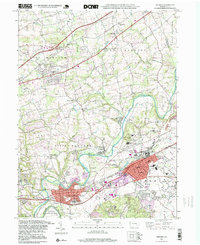 1995 Hershey1999 Print · USGSDauphin County’s industrial and institutional landscape is well-established by the mid-nineties, centered on the growing communities of Hershey and Hummelstown. Researchers can trace the path of the Union Canal or locate family roots at Fishburns Cem and Shells Ch.
 - 1999 Map of Middletown, 2001 Print
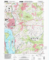 1999 Middletown2001 Print · USGSThe Lower Susquehanna valley at the turn of the millennium shows a complex mix of industrial infrastructure and rural traditions. Researchers can trace the development of Middletown and Royalton or locate family sites like Stoverdale Ch and Goldsboro (Etters PO).
 - 1999 Map of Elizabethtown, 2001 Print
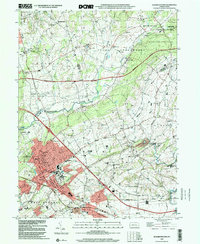 1999 Elizabethtown2001 Print · USGSElizabethtown and the fertile borderlands of Lancaster and Dauphin counties are shown here just before the turn of the millennium. Genealogists can trace family names and sites through Oberholtzer Cem, Masonic Sch, and rural villages like Bellaire.
End of results
Showing maps 1-3 of 3
Top cities near Derry Township
- Harrisburg historical maps
- Lebanon historical maps
- Colonial Park historical maps
- Hershey historical maps
- Elizabethtown historical maps
- Progress historical maps
See more
Top neighborhoods of Derry Township
- Waltonville historical maps
- Wood Ridge Manor historical maps
- Edgewood Hills historical maps
- Oakmont historical maps
- Laurel Woods historical maps
- Sandhill historical maps
See more
Frequently asked questions
- What are the different types of historical maps available for Derry Township?
- What is the oldest map of Derry Township?
- Where can I purchase historical maps of Derry Township for my home or office?
- Where can I download high-res historical maps of Derry Township?
- Are there historical topographic maps available for Derry Township?
- Is there historical aerial imagery available for Derry Township?
- Where are historical maps of Derry Township sourced from?