1990s Maps of Erie County, Pennsylvania
Explore 9 historic maps of Erie County from the 1990s. These maps offer a rare glimpse into what life looked like during the 1990s — showing old roads, neighborhoods, homes, and landmarks that have changed or disappeared over time.
Whether you're researching your family's past, planning a metal detecting trip, or studying how Erie County's landscape evolved across the 1990s, these high-resolution maps are a powerful tool for exploring the history of this region.
- Focus on a specific era: All maps on this page are from the 1990s, giving you a focused view of this time period.
- See what’s changed: Compare century-old streets, trails, and buildings to today's modern landscape using overlays and satellite layers.
- Research with precision: Use these maps for genealogy, historical research, land use analysis, or educational projects.
- View, download, or print: Maps are fully viewable online in high resolution, and can be downloaded or printed for your own records.
Start exploring Erie County's history through authentic maps from the 1990s. This is your window into the past.
Erie County, PA maps
(9)- 1994 Map of Pierpont, 1997 Print
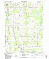 1994 Pierpont1997 Print · USGSAshtabula County's rural borderlands remained a mosaic of energy extraction and small-town crossroads in the late twentieth century. Genealogists and historians can trace family locations through Evergreen Cem, identify old homesteads near Bushnell, or find the historic Covered Bridge on the Ashtabula River.
 - 1996 Map of Fairview SW
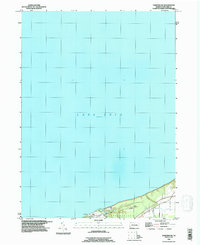 1996 Fairview SW1996 Print · USGSThe Erie County shoreline in the mid-1990s reveals a landscape of lakeside retreats and township boundaries. Researchers can trace the development of coastal recreation at Camp Fitch, Camp Sequoyah, and the small community at Dans Beach.
 - 1996 Map of Erie North
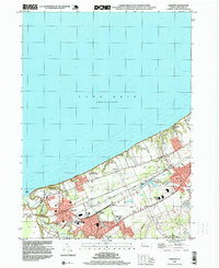
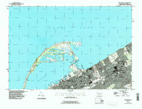 1996 Erie North1996 Print · USGSThe Pennsylvania lakefront at the end of the century shows a bustling maritime hub defined by the unique arc of Presque Isle. Genealogists and local historians can trace civic life through Lakeside Cemetery, Gannon University, and the many neighborhood parochial schools.
 - 1996 Map of Conneaut
 1996 Conneaut1996 Print · USGSThe Ohio-Pennsylvania borderlands come into focus in the mid-nineties as industrial shipping hubs meet rural crossroads. Genealogists and historians can trace family plots at St Josephs Cem or locate former schoolhouses like Rows Sch and Chestnut Sch.
 - 1996 Map of Harborcreek
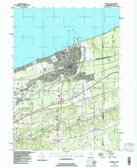
 1996 Harborcreek1996 Print · USGSCoastal Erie County in the mid-nineties shows a landscape of established lakeside communities and ripening transit corridors. Researchers can trace family sites at St Gregory Cem, locate the Drive-in Theater, or study the rail networks of Conrail.
 - 1996 Map of North East, 1997 Print
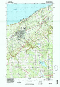 1996 North East1997 Print · USGSThe Lake Erie shoreline in the mid-1990s reveals a landscape of lakeside recreation, agriculture, and transport at the New York border. Researchers can trace local lineage through sites like Northville Cemetery, Merryhurst College, and the family-named Delhill Corners.
 - 1996 Map of Erie South, 1997 Print
 1996 Erie South1997 Print · USGSGreater Erie in the late nineties shows a city in transition, where established neighborhoods meet the expanding suburbs of Summit Township. Genealogists can trace family sites from Erie Cem and Wintergreen Gorge Cem to schools like McKinley Sch and Tech High Sch.
 - 1998 Map of Fairview, 1999 Print
 1998 Fairview1999 Print · USGSThe Lake Erie shoreline in the late nineties shows a well-established network of rail junctions and residential lakefront communities. Genealogists and historians can locate legacy institutions like the Divine Word Seminary, St Johns Cem, and Wallace Junction.
 - 1998 Map of Swanville, 1999 Print
 1998 Swanville1999 Print · USGSThe Lake Erie shoreline and the expanding suburbs of Erie are captured here in the late nineties as modern infrastructure began to reshape the landscape. Genealogists and local historians can locate Trinity Cem, Villa Maria Academy, and the early layout of Swanville.
End of results
Showing maps 1-9 of 9
Top cities of Erie County
- Erie historical maps
- Harborcreek Township historical maps
- Fairview Township historical maps
- North East historical maps
- Corry historical maps
- Edinboro historical maps
See more
Frequently asked questions
- What are the different types of historical maps available for Erie County?
- What is the oldest map of Erie County?
- Where can I purchase historical maps of Erie County for my home or office?
- Where can I download high-res historical maps of Erie County?
- Are there historical topographic maps available for Erie County?
- Is there historical aerial imagery available for Erie County?
- Where are historical maps of Erie County sourced from?