1950s Maps of Greene Township, Pennsylvania
Explore 8 historic maps of Greene Township from the 1950s. These maps offer a rare glimpse into what life looked like during the 1950s — showing old roads, neighborhoods, homes, and landmarks that have changed or disappeared over time.
Whether you're researching your family's past, planning a metal detecting trip, or studying how Greene Township's landscape evolved across the 1950s, these high-resolution maps are a powerful tool for exploring the history of this region.
- Focus on a specific era: All maps on this page are from the 1950s, giving you a focused view of this time period.
- See what’s changed: Compare century-old streets, trails, and buildings to today's modern landscape using overlays and satellite layers.
- Research with precision: Use these maps for genealogy, historical research, land use analysis, or educational projects.
- View, download, or print: Maps are fully viewable online in high resolution, and can be downloaded or printed for your own records.
Start exploring Greene Township's history through authentic maps from the 1950s. This is your window into the past.
Greene Township, PA maps
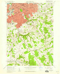
(8)- 1950 Map of Cleveland
 1950 Cleveland1950 Print · USGSCovers Greene Township, including Cleveland, Akron, and other nearby areas
 - 1950 Map of Erie, 1953 Print
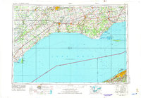
 1950 Erie1953 Print · USGSThe northern and southern shores of the Great Lakes meet in the mid-twentieth century, showcasing the vital shipping and rail corridors between Ontario and Pennsylvania. Trace the routes of the Michigan Central railroad or locate coastal landmarks like Presque Isle Light and the settlement of Iona Station.
 - 1956 Map of Cleveland, 1967 Print
 1956 Cleveland1967 Print · USGSNortheast Ohio and Western Pennsylvania are shown at their industrial height during the mid-fifties, from the steel mills to the lakeshore. Researchers can trace the massive Ravenna Arsenal, the Ohio Turnpike, and vanished rail sidings of the B & O RR.3 unique versions available
 - 1957 Map of Erie South, 1959 Print
 1957 Erie South1959 Print · USGSMid-century Erie shows its southern expansion toward the hills of Summit Township just as suburban growth began to accelerate. Genealogists and local researchers can locate numerous parish schools, the sprawling Erie Cemetery, and rural landmarks like St Matthews Ch and Five Points.4 unique versions available
 - 1957 Map of Warren, 1964 Print
 1957 Warren1964 Print · USGSThe northern Pennsylvania oil and timber country comes into focus in the mid-fifties, showing the region before modern highway expansions. Trace the industrial rail networks of the Pennsylvania RR and the early Allegheny River Reservoir near Warren and Oil City.4 unique versions available
 - 1958 Map of Warren
 1958 Warren1958 Print · USGSNorthern Pennsylvania’s timber and oil country is captured here during the late fifties, showing the interplay of industrial valleys and vast state forests. Genealogists can trace family connections across the Cornplanter Indian Reservation or through rail hubs like Oil City and Saint Marys.
 - 1959 Map of Warren
 1959 Warren1959 Print · USGSNorthern Pennsylvania's oil and timber country comes alive in this late-fifties study of the forest-clad plateaus. Trace the historic Cornplanter (Indian Reservation), the sprawling Oil Field, and the rail lines of the Pennsylvania RR.2 unique versions available
 - 1959 Map of Erie, 1974 Print
 1959 Erie1974 Print · USGSCoastal communities and busy international rail lines define the North Shore and Pennsylvania lakefront during the late fifties and early seventies. Researchers can trace historic docklands and depot sites in Erie, Port Burwell, and Simcoe alongside the extensive reaches of Long Point.2 unique versions available
End of results
Showing maps 1-8 of 8
Top cities near Greene Township
- Erie historical maps
- Harborcreek Township historical maps
- Fairview Township historical maps
- North East historical maps
- Edinboro historical maps
- Lawrence Park Township historical maps
See more
Top neighborhoods of Greene Township
- Belleview Heights historical maps
- Kuhl historical maps
- Sampson historical maps
- Weeds Corners historical maps
- West Greene historical maps
- Bogus Corners historical maps
See more
Frequently asked questions
- What are the different types of historical maps available for Greene Township?
- What is the oldest map of Greene Township?
- Where can I purchase historical maps of Greene Township for my home or office?
- Where can I download high-res historical maps of Greene Township?
- Are there historical topographic maps available for Greene Township?
- Is there historical aerial imagery available for Greene Township?
- Where are historical maps of Greene Township sourced from?