1930s Maps of Rasler Run, Springfield Township
Explore 1 historic maps of Rasler Run from the 1930s. These maps offer a rare glimpse into what life looked like during the 1930s — showing old roads, neighborhoods, homes, and landmarks that have changed or disappeared over time.
Whether you're researching your family's past, planning a metal detecting trip, or studying how Rasler Run's landscape evolved across the 1930s, these high-resolution maps are a powerful tool for exploring the history of this region.
- Focus on a specific era: All maps on this page are from the 1930s, giving you a focused view of this time period.
- See what’s changed: Compare century-old streets, trails, and buildings to today's modern landscape using overlays and satellite layers.
- Research with precision: Use these maps for genealogy, historical research, land use analysis, or educational projects.
- View, download, or print: Maps are fully viewable online in high resolution, and can be downloaded or printed for your own records.
Start exploring Rasler Run's history through authentic maps from the 1930s. This is your window into the past.
Rasler Run, Springfield Township maps
(1)- 1935 Map of Donegal
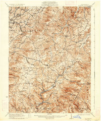 1935 Donegal1935 Print · USGSWestmoreland County communities are shown here in the 1930s, as coal towns and rural hamlets relied on a network of mountain rail lines and country schools. Genealogists can trace family roots through numerous sites like Stahlstown, the Mansville Post Office, and St Boniface Chapel.2 unique versions available
End of results
Showing maps 1-1 of 1
Top cities near Rasler Run
- Connellsville historical maps
- Scottdale historical maps
- Mount Pleasant historical maps
- South Connellsville historical maps
- New Stanton historical maps
- Dunbar historical maps
See more
Frequently asked questions
- What are the different types of historical maps available for Rasler Run?
- What is the oldest map of Rasler Run?
- Where can I purchase historical maps of Rasler Run for my home or office?
- Where can I download high-res historical maps of Rasler Run?
- Are there historical topographic maps available for Rasler Run?
- Is there historical aerial imagery available for Rasler Run?
- Where are historical maps of Rasler Run sourced from?