1990s Maps of Stewart Township, Pennsylvania
Explore 3 historic maps of Stewart Township from the 1990s. These maps offer a rare glimpse into what life looked like during the 1990s — showing old roads, neighborhoods, homes, and landmarks that have changed or disappeared over time.
Whether you're researching your family's past, planning a metal detecting trip, or studying how Stewart Township's landscape evolved across the 1990s, these high-resolution maps are a powerful tool for exploring the history of this region.
- Focus on a specific era: All maps on this page are from the 1990s, giving you a focused view of this time period.
- See what’s changed: Compare century-old streets, trails, and buildings to today's modern landscape using overlays and satellite layers.
- Research with precision: Use these maps for genealogy, historical research, land use analysis, or educational projects.
- View, download, or print: Maps are fully viewable online in high resolution, and can be downloaded or printed for your own records.
Start exploring Stewart Township's history through authentic maps from the 1990s. This is your window into the past.
Stewart Township, PA maps
(3)- 1999 Map of Mill Run, 2000 Print
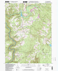 1999 Mill Run2000 Print · USGSThe Youghiogheny River corridor and Laurel Highlands appear here at the end of the millennium. Trace the rural landscape through Mill Run Reservoir and local centers like Normalville, or find family sites at Hickman Chapel and Mt Tabor Cem.
 - 1999 Map of Ohiopyle, 2000 Print
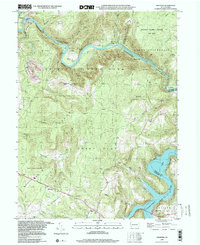 1999 Ohiopyle2000 Print · USGSFayette County's river-carved landscape is captured here as the century turned, centered on the dramatic bends of the Youghiogheny River. Researchers can locate legacy sites like Bidwell Sta, the Marclay Sch, and numerous family burial grounds including Sugarloaf Cem.
 - 1999 Map of South Connellsville, 2000 Print
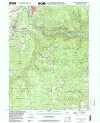 1999 South Connellsville2000 Print · USGSFayette County’s industrial and highland character is on full display in the 1990s as the river-and-rail economy meets conservation. Researchers can trace historic neighborhoods like Brown Row, find the old Iron Furnace, or locate family sites at Mt Olive Cem and Roebuck Cem.
End of results
Showing maps 1-3 of 3
Top cities near Stewart Township
- Uniontown historical maps
- Connellsville historical maps
- Scottdale historical maps
- South Connellsville historical maps
- Dunbar historical maps
- Everson historical maps
See more
Top neighborhoods of Stewart Township
Frequently asked questions
- What are the different types of historical maps available for Stewart Township?
- What is the oldest map of Stewart Township?
- Where can I purchase historical maps of Stewart Township for my home or office?
- Where can I download high-res historical maps of Stewart Township?
- Are there historical topographic maps available for Stewart Township?
- Is there historical aerial imagery available for Stewart Township?
- Where are historical maps of Stewart Township sourced from?