1960s Maps of Whig Hill, Kingsley Township
Explore 1 historic maps of Whig Hill from the 1960s. These maps offer a rare glimpse into what life looked like during the 1960s — showing old roads, neighborhoods, homes, and landmarks that have changed or disappeared over time.
Whether you're researching your family's past, planning a metal detecting trip, or studying how Whig Hill's landscape evolved across the 1960s, these high-resolution maps are a powerful tool for exploring the history of this region.
- Focus on a specific era: All maps on this page are from the 1960s, giving you a focused view of this time period.
- See what’s changed: Compare century-old streets, trails, and buildings to today's modern landscape using overlays and satellite layers.
- Research with precision: Use these maps for genealogy, historical research, land use analysis, or educational projects.
- View, download, or print: Maps are fully viewable online in high resolution, and can be downloaded or printed for your own records.
Start exploring Whig Hill's history through authentic maps from the 1960s. This is your window into the past.
Whig Hill, Kingsley Township maps
(1)- 1966 Map of Kelletteville, 1967 Print
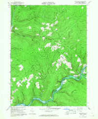 1966 Kelletteville1967 Print · USGSForest County in the mid-1960s shows a landscape of deep timber and evolving waterways within the Allegheny National Forest. Researchers can trace the heritage of Kellettville, locate the Whig Hill Cemetery, and follow the path of an Old Railroad Grade along the creek.3 unique versions available
End of results
Showing maps 1-1 of 1
Top cities near Whig Hill
- Sheffield Township historical maps
- Pittsfield Township historical maps
- Tidioute historical maps
- Tionesta historical maps
- Clarendon historical maps
- President Township historical maps
See more
Frequently asked questions
- What are the different types of historical maps available for Whig Hill?
- What is the oldest map of Whig Hill?
- Where can I purchase historical maps of Whig Hill for my home or office?
- Where can I download high-res historical maps of Whig Hill?
- Are there historical topographic maps available for Whig Hill?
- Is there historical aerial imagery available for Whig Hill?
- Where are historical maps of Whig Hill sourced from?