1950s Maps of Franklin County, Pennsylvania
Explore 18 historic maps of Franklin County from the 1950s. These maps offer a rare glimpse into what life looked like during the 1950s — showing old roads, neighborhoods, homes, and landmarks that have changed or disappeared over time.
Whether you're researching your family's past, planning a metal detecting trip, or studying how Franklin County's landscape evolved across the 1950s, these high-resolution maps are a powerful tool for exploring the history of this region.
- Focus on a specific era: All maps on this page are from the 1950s, giving you a focused view of this time period.
- See what’s changed: Compare century-old streets, trails, and buildings to today's modern landscape using overlays and satellite layers.
- Research with precision: Use these maps for genealogy, historical research, land use analysis, or educational projects.
- View, download, or print: Maps are fully viewable online in high resolution, and can be downloaded or printed for your own records.
Start exploring Franklin County's history through authentic maps from the 1950s. This is your window into the past.
Franklin County, PA maps
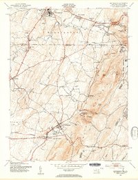
(18)- 1950 Map of Harrisburg, 1952 Print
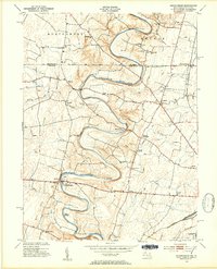
 1950 Harrisburg1952 Print · USGSMid-century Central Pennsylvania comes alive through its dense rail networks and river valley settlements during the post-war industrial era. Genealogists and historians can trace family roots through hubs like Harrisburg, locate Carlisle Barracks, or follow the Pennsylvania RR through the Lebanon Valley.
 - 1951 Map of Cherry Run, 1953 Print
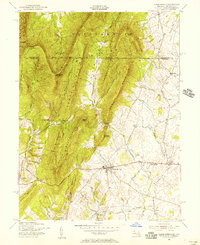
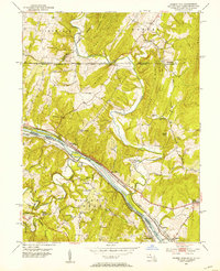 1951 Cherry Run1953 Print · USGSThe Potomac River valley and its rugged ridges are captured here during the early fifties as the region's transport network evolved. Genealogists and rail historians can trace the paths of the National Pike, the Baltimore and Ohio Railroad, and the Chesapeake and Ohio Canal (Abandoned).8 unique versions available
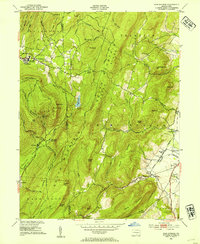
 - 1951 Map of Fairfield, 1954 Print
 1951 Fairfield1954 Print · USGSSouth Mountain and the Adams County fruit belt are captured here in the early fifties. Genealogists can trace family footprints through numerous rural schools like Pitzer Sch and settlements such as Arendtsville and Maria Furnace.3 unique versions available
 - 1952 Map of Cumberland
 1952 Cumberland1952 Print · USGSThe Potomac Highlands and the Shenandoah Valley are revealed in this early 1950s survey of the Appalachian interior. Researchers can trace the river-and-rail corridors connecting Cumberland, Winchester, and the recreational waters of Deep Creek Lake.
 - 1952 Map of Walnut Bottom, 1958 Print
 1952 Walnut Bottom1958 Print · USGSCumberland County at the mid-century shows a landscape of ridge-top trails and valley schoolhouses. Genealogists can locate family landmarks like Lees Cross Roads and Cleversburg, or trace the rural routes between Newton Township Consolidated School and Spring Hill School.4 unique versions available
 - 1952 Map of Newville, 1959 Print
 1952 Newville1959 Print · USGSCumberland County communities and traditional farmsteads are documented here in the early fifties, just as the turnpike began to reshape the valley. Genealogists can locate family landmarks like Moors Mill, Bethany Ch, and the many rural schoolhouses from Gillespie Sch to Pine Road Sch.3 unique versions available
 - 1953 Map of Iron Springs, 1954 Print
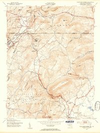
 1953 Iron Springs1954 Print · USGSAdams County in the early fifties shows a landscape of mountain ridges and valley farms. Genealogists can locate old family landmarks like Chamberlains Hill, trace the Appalachian Trail, or find the historic Maria Furnace site.5 unique versions available
 - 1953 Map of Mason-Dixon, 1954 Print
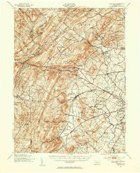
 1953 Mason-Dixon1954 Print · USGSThe Mason-Dixon line bisects this fertile valley in the early 1950s, where the winding Conococheague Creek meets a network of country roads. Genealogists can trace old family sites and schools like Sunrise Sch, Steckerberger Sch, and the hamlet of Huyett.4 unique versions available
 - 1953 Map of Hagerstown, 1954 Print
 1953 Hagerstown1954 Print · USGSHagerstown and the Maryland-Pennsylvania borderlands thrive during the mid-fifties as a hub of rail commerce and agricultural industry. Genealogists and historians can trace family locations through numerous rural schoolhouses like Greenmount Sch, local churches such as Paradise Ch, and the complex rail network of the Western Maryland and Pennsylvania lines.4 unique versions available
 - 1953 Map of Blue Ridge Summit, 1955 Print
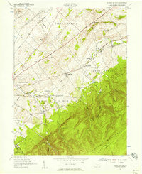
 1953 Blue Ridge Summit1955 Print · USGSMaryland and Pennsylvania meet along the mountain crests in the early fifties, where the railroad and state line define local life. Genealogists and hikers can trace the Western Maryland tracks past Wesley Chapel, Charmian, and the Victor Cullen State Hospital.7 unique versions available
 - 1953 Map of Smithsburg, 1955 Print
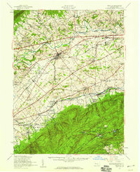
 1953 Smithsburg1955 Print · USGSThe Maryland-Pennsylvania borderlands come alive in the early 1950s, showing the intersection of ridge-top recreation and valley agriculture. Researchers can trace the Mason and Dixon Line, locate historic sites like Pen Mar Park, and follow the Western Maryland rail line.5 unique versions available
 - 1954 Map of Baltimore
 1954 Baltimore1954 Print · USGSThe Mid-Atlantic region in the early fifties shows a landscape of growing suburban centers and heavy rail corridors. Trace mid-century transit networks and military landmarks from the Aberdeen Proving Ground to the Gettysburg National Military Park.
 - 1955 Map of Clear Spring, 1956 Print
 1955 Clear Spring1956 Print · USGSThe Maryland-Pennsylvania borderlands are captured here in the mid-fifties, centered on the historic Mason and Dixon Line. Researchers and genealogists can trace the rural network of the National Pike through Kasiesville and locate family sites like Cushwa Cem.3 unique versions available
 - 1956 Map of Baltimore
 1956 Baltimore1956 Print · USGSMid-century Maryland and Pennsylvania are captured here during a period of massive suburban and military growth across the Chesapeake region. Genealogists and historians can trace the rail corridors of the Baltimore & Ohio RR and locate landmarks like Fort McHenry or the Aberdeen Proving Ground.
 - 1956 Map of Cumberland, 1966 Print
 1956 Cumberland1966 Print · USGSThe tri-state Highlands in the mid-1950s show a landscape shaped by coal, timber, and the massive presence of the Baltimore & Ohio RR. Researchers can trace the industrial corridor from Cumberland through the Allegheny Mountains to mountain retreats like Deep Creek Lake.6 unique versions available
 - 1957 Map of Harrisburg
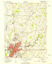
 1957 Harrisburg1957 Print · USGSMid-century Central Pennsylvania comes into focus as a bustling network of rail, river, and mountain ridges. Genealogists and historians can trace the development of the State Capitol and surrounding hubs like Middletown, Columbia, and Pottsville.7 unique versions available
 - 1957 Map of Cumberland
 1957 Cumberland1957 Print · USGSThe Potomac River valley and the ridges of the Allegheny Front define this mid-century landscape at the intersection of Maryland, West Virginia, and Pennsylvania. Trace the steam-era rail lines of the Baltimore and Ohio RR or locate rural landmarks like St Stephens Church and Stony River Dam.
 - 1957 Map of Baltimore, 1964 Print
 1957 Baltimore1964 Print · USGSMaryland and Southern Pennsylvania are shown during the mid-century expansion of the Baltimore-Washington corridor. Researchers can trace the extensive rail lines of the Baltimore & Ohio RR and locate sites like Fort Detrick and Gettysburg National Military Park.5 unique versions available
End of results
Showing maps 1-18 of 18
Top cities of Franklin County
- Chambersburg historical maps
- Waynesboro historical maps
- Quincy Township historical maps
- Greencastle historical maps
- Lurgan Township historical maps
- Guilford Township historical maps
See more
Frequently asked questions
- What are the different types of historical maps available for Franklin County?
- What is the oldest map of Franklin County?
- Where can I purchase historical maps of Franklin County for my home or office?
- Where can I download high-res historical maps of Franklin County?
- Are there historical topographic maps available for Franklin County?
- Is there historical aerial imagery available for Franklin County?
- Where are historical maps of Franklin County sourced from?