1920s Maps of Franklin County, Pennsylvania
Explore 2 historic maps of Franklin County from the 1920s. These maps offer a rare glimpse into what life looked like during the 1920s — showing old roads, neighborhoods, homes, and landmarks that have changed or disappeared over time.
Whether you're researching your family's past, planning a metal detecting trip, or studying how Franklin County's landscape evolved across the 1920s, these high-resolution maps are a powerful tool for exploring the history of this region.
- Focus on a specific era: All maps on this page are from the 1920s, giving you a focused view of this time period.
- See what’s changed: Compare century-old streets, trails, and buildings to today's modern landscape using overlays and satellite layers.
- Research with precision: Use these maps for genealogy, historical research, land use analysis, or educational projects.
- View, download, or print: Maps are fully viewable online in high resolution, and can be downloaded or printed for your own records.
Start exploring Franklin County's history through authentic maps from the 1920s. This is your window into the past.
Franklin County, PA maps
(2)- 1923 Map of Shippensburg
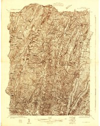
 1923 Shippensburg1923 Print · USGSShippensburg and its surrounding valley floor were defined by the rail lines and agricultural networks of the early twentieth century. Genealogists can locate dozens of country schools and churches, including Brookside School, Lurgan Sta, and the State Normal School campus.3 unique versions available
 - 1925 Map of Needmore
 1925 Needmore1925 Print · USGSFulton County’s ridges and valleys are meticulously detailed in the mid-1920s, showing the early path of the Lincoln Highway. Researchers can locate dozens of country institutions, from the Old Mountain House to the Sideling Hill Baptist Church and Sipes Mill.
End of results
Showing maps 1-2 of 2
Top cities of Franklin County
- Chambersburg historical maps
- Waynesboro historical maps
- Quincy Township historical maps
- Greencastle historical maps
- Lurgan Township historical maps
- Guilford Township historical maps
See more
Frequently asked questions
- What are the different types of historical maps available for Franklin County?
- What is the oldest map of Franklin County?
- Where can I purchase historical maps of Franklin County for my home or office?
- Where can I download high-res historical maps of Franklin County?
- Are there historical topographic maps available for Franklin County?
- Is there historical aerial imagery available for Franklin County?
- Where are historical maps of Franklin County sourced from?