Old Maps of Franklin County, Pennsylvania for Genealogy
Trace your family roots with 138 historic maps of Franklin County. These high-res maps reveal old neighborhoods, homesites, landmarks, and streets — helping you uncover where your ancestors lived and how the area evolved over time.
- Explore historic neighborhoods: Identify where your relatives may have lived in the 1800s or 1900s.
- Compare maps over time: Trace the changes in streets, buildings, and landmarks for multi-generational research.
- Perfect for genealogy & ancestry research: Used by family historians and researchers to map out lineage and migration.
These maps are an incredible resource for exploring your personal connection to Franklin County's past.
Franklin County, PA maps
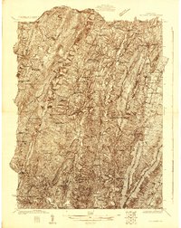
(138)- 1899 Map of Hancock, 1960 Print
 1899 Hancock1960 Print · USGSThe Potomac River valley at the turn of the century shows a bustling corridor of trade where Maryland, West Virginia, and Pennsylvania meet. Genealogy researchers can trace family landmarks like Stotlers Crossroads, Yeakle Mill, and the historic Fort Frederick.
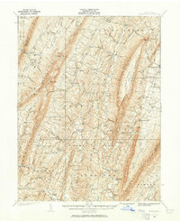
 - 1900 Map of Mercersburg
 1900 Mercersburg1900 Print · USGSFranklin County at the turn of the century is captured here as a landscape of iron furnaces and valley farms. Trace the early transport lines through Mercersburg, Richmond Furnace, and the old Southern Pennsylvania Br. rail line.
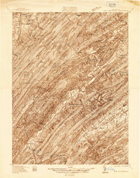
 - 1901 Map of Hancock
 1901 Hancock1901 Print · USGSMaryland and West Virginia met at the turn of the century along a busy corridor of river transport and rail expansion. Genealogists can trace family roots through old landmarks like Yeakle Mill, Fairview Church, and early hamlets such as Stotlers Crossroads.8 unique versions available
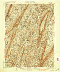
 - 1902 Map of Chambersburg
 1902 Chambersburg1902 Print · USGSFranklin County at the dawn of the new century shows a thriving valley dominated by the rail lines connecting Chambersburg, Greencastle, and Waynesboro. Genealogists and historians can trace long-gone stops and industrial sites like Guilford Siding, Browns Mills, and the Pond Bank iron area.7 unique versions available
 - 1902 Map of Mercersburg
 1902 Mercersburg1902 Print · USGSFranklin and Fulton counties at the opening of the twentieth century show a landscape defined by iron furnaces and mountain gaps. Genealogists and historians can trace rail lines to Mercersburg Junction or locate family sites near Welsh Run and Foltz.5 unique versions available
 - 1909 Map of Fairfield
 1909 Fairfield1909 Print · USGSAdams County at the turn of the century shows a landscape of mountain sanitaria, early iron works, and a dense network of country schoolhouses. Genealogists and researchers can trace the old Western Maryland Railroad route and locate landmarks like Maria Furnace, Cashtown, and the South Mountain Sanatorium.6 unique versions available
 - 1909 Map of Hagerstown
 1909 Hagerstown1909 Print · USGSHagerstown and the Antietam valley appear here during the height of the steam rail era, shortly after the turn of the century. Genealogists and historians can locate family homesteads near landmarks like St James Church, Smoketown School, and the Hagerstown and Boonsboro Ry.
 - 1911 Map of Emmitsburg
 1911 Emmitsburg1911 Print · USGSMaryland's northern borderlands and the Catoctin mountains thrived in the early twentieth century as a hub for institutions, railroads, and milling. Genealogists and historians can locate family homes and old crossroads near St Josephs Academy, Sabillasville, and the Western Maryland RR.6 unique versions available
 - 1912 Map of Hagerstown
 1912 Hagerstown1912 Print · USGSMaryland's Cumberland Valley flourished as a rail and milling corridor during the early twentieth century. Genealogists can trace family names across dozens of rural landmarks like Strites Mill, Hallowell Church, and the Paradise School.9 unique versions available
 - 1912 Map of Williamsport
 1912 Williamsport1912 Print · USGSUpper Maryland and the West Virginia panhandle were bustling centers of river and rail transit before the First World War. Researchers can trace the path of the Chesapeake and Ohio Canal and locate family landmarks like Cushwa Mill or the St James School.3 unique versions available
 - 1919 Map of Newville
 1919 Newville1919 Print · USGSCumberland County life in the late teens centers on the rail corridors and water mills between the mountains. Trace family roots at Newville or Pine Grove Furnace, and locate rural landmarks like Reiters Mill and Miller Church.6 unique versions available
 - 1919 Map of Mattawana
 1919 Mattawana1919 Print · USGSCentral Pennsylvania's ridge-and-valley network is captured here at the end of the Great War, showing a landscape defined by small mill towns and diverging rail lines. Genealogists can trace family names and ancestral homes in McCulloch Mills, E. Waterford, and Blairs Mills.
 - 1923 Map of Shippensburg
 1923 Shippensburg1923 Print · USGSShippensburg and its surrounding valley floor were defined by the rail lines and agricultural networks of the early twentieth century. Genealogists can locate dozens of country schools and churches, including Brookside School, Lurgan Sta, and the State Normal School campus.3 unique versions available
 - 1925 Map of Needmore
 1925 Needmore1925 Print · USGSFulton County’s ridges and valleys are meticulously detailed in the mid-1920s, showing the early path of the Lincoln Highway. Researchers can locate dozens of country institutions, from the Old Mountain House to the Sideling Hill Baptist Church and Sipes Mill.
 - 1935 Map of Needmore
 1935 Needmore1935 Print · USGSFulton County settlements and ridge-and-valley farmsteads are documented here in the years before the Second World War. Genealogists can trace family names at Wink Cem or locate rural landmarks like Hammans Store, Sipes Mill, and Big Cove Tannery.
 - 1936 Map of East Waterford
 1936 East Waterford1936 Print · USGSThe ridge-and-valley corridor of Juniata and Perry Counties is captured here in the mid-1930s, showing a landscape defined by narrow mountain gaps and small milling hubs. Researchers can trace ancestral roots through dozens of rural schools and churches, including McCulloughs Mills, Honey Grove, and Fairview Ch and Sch.2 unique versions available
 - 1939 Map of Needmore
 1939 Needmore1939 Print · USGSFulton County and the Bedford-Franklin borderlands appear here in the late thirties, showing a rural landscape defined by steep ridges and narrow valleys. Researchers can locate family landmarks like Sipes Mill, Wink Cem, and the Big Cove Tannery.3 unique versions available
 - 1939 Map of Orbisonia, 1954 Print
 1939 Orbisonia1954 Print · USGSOrbisonia and the surrounding mountain gaps are captured in the late thirties just as the modern turnpike was transforming the valley. Researchers can trace the narrow-gauge East Broad Top RR or find rural landmarks like Burnt Cabins and Jordan Cem.7 unique versions available
 - 1940 Map of Orbisonia
 1940 Orbisonia1940 Print · USGSCentral Pennsylvania's Ridge and Valley province is captured here just as the Pennsylvania Turnpike reached Burnt Cabins. Researchers can trace the narrow-gauge EAST BROAD TOP RR and locate family landmarks like Jordan Cem, Kuhns Mill, or St Marys Ch.2 unique versions available
 - 1941 Map of East Waterford
 1941 East Waterford1941 Print · USGSThe Ridge-and-Valley province of Central Pennsylvania appears here in the years before the war, dominated by the great parallel spans of Tuscarora Mountain. Genealogists can locate family sites among numerous rural institutions like Pine Glen Ch, McCullochs Mills, and the CCC Camp at East Waterford.3 unique versions available
 - 1942 Map of Hagerstown
 1942 Hagerstown1942 Print · USGSThe Cumberland Valley and Potomac corridor are captured here at the height of the Second World War rail-and-river era. Genealogists and historians can trace the industrial landscape of Richmond Furnace, the route of the Chesapeake and Ohio Canal, and the grounds of Camp Ritchie.
 - 1942 Map of Gettysburg, 1944 Print
 1942 Gettysburg1944 Print · USGSGettysburg and its surrounding borderlands are shown in great detail during the early 1940s, capturing the region's dense network of rural schools and mills. Genealogists can trace family-named landmarks such as Galt Kump PO, Hafers Mill, and Philips Delight Sch.
 - 1943 Map of Emmitsburg
 1943 Emmitsburg1943 Print · USGSMaryland's northern border and the Frederick Valley appear during the early 1940s, where the Catoctin range meets the Monocacy plain. Genealogists can trace family names at Hoovers Mill, locate historic institutions like Mount St Marys College, or follow the Western Maryland RR.4 unique versions available
 - 1943 Map of Hagerstown
 1943 Hagerstown1943 Print · USGSThe Cumberland Valley was a critical wartime logistics hub in the 1940s, teeming with rail traffic and new military installations. Genealogists and historians can trace the Chesapeake and Ohio Canal or locate local landmarks like Richmond Furnace and Camp Ritchie.
 - 1943 Map of Mercersburg, 1952 Print
 1943 Mercersburg1952 Print · USGSMercersburg and the surrounding Cumberland Valley are shown here during the early 1940s as a landscape of rural school districts and rail-side hamlets. Researchers can trace family roots at Mercersburg Academy or locate old sites like Heimbaugh Lime and Claylick Sch.6 unique versions available
Showing maps 1-25 of 138
Top cities of Franklin County
- Chambersburg historical maps
- Waynesboro historical maps
- Quincy Township historical maps
- Greencastle historical maps
- Lurgan Township historical maps
- Guilford Township historical maps
See more
Frequently asked questions
- What are the different types of historical maps available for Franklin County?
- What is the oldest map of Franklin County?
- Where can I purchase historical maps of Franklin County for my home or office?
- Where can I download high-res historical maps of Franklin County?
- Are there historical topographic maps available for Franklin County?
- Is there historical aerial imagery available for Franklin County?
- Where are historical maps of Franklin County sourced from?