1940s Maps of Montgomery Township, Pennsylvania
Explore 10 historic maps of Montgomery Township from the 1940s. These maps offer a rare glimpse into what life looked like during the 1940s — showing old roads, neighborhoods, homes, and landmarks that have changed or disappeared over time.
Whether you're researching your family's past, planning a metal detecting trip, or studying how Montgomery Township's landscape evolved across the 1940s, these high-resolution maps are a powerful tool for exploring the history of this region.
- Focus on a specific era: All maps on this page are from the 1940s, giving you a focused view of this time period.
- See what’s changed: Compare century-old streets, trails, and buildings to today's modern landscape using overlays and satellite layers.
- Research with precision: Use these maps for genealogy, historical research, land use analysis, or educational projects.
- View, download, or print: Maps are fully viewable online in high resolution, and can be downloaded or printed for your own records.
Start exploring Montgomery Township's history through authentic maps from the 1940s. This is your window into the past.
Montgomery Township, PA maps
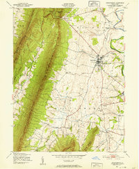
(10)- 1942 Map of Hagerstown
 1942 Hagerstown1942 Print · USGSThe Cumberland Valley and Potomac corridor are captured here at the height of the Second World War rail-and-river era. Genealogists and historians can trace the industrial landscape of Richmond Furnace, the route of the Chesapeake and Ohio Canal, and the grounds of Camp Ritchie.
 - 1943 Map of Hagerstown
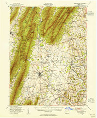
 1943 Hagerstown1943 Print · USGSThe Cumberland Valley was a critical wartime logistics hub in the 1940s, teeming with rail traffic and new military installations. Genealogists and historians can trace the Chesapeake and Ohio Canal or locate local landmarks like Richmond Furnace and Camp Ritchie.
 - 1943 Map of Mercersburg, 1952 Print
 1943 Mercersburg1952 Print · USGSMercersburg and the surrounding Cumberland Valley are shown here during the early 1940s as a landscape of rural school districts and rail-side hamlets. Researchers can trace family roots at Mercersburg Academy or locate old sites like Heimbaugh Lime and Claylick Sch.6 unique versions available
 - 1943 Map of Mercersburg, 1955 Print
 1943 Mercersburg1955 Print · USGSFranklin County in the 1940s is captured here in its transition from a ridge-and-valley wilderness to a settled agricultural heartland. Genealogists can trace family landmarks like Claylick Sch, the historic Mercersburg Academy, and the village of Fort Loudon.2 unique versions available
 - 1944 Map of Clear Spring
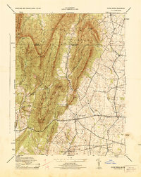 1944 Clear Spring1944 Print · USGSMaryland's Ridge and Valley province is captured here during the mid-1940s, showing a landscape defined by mountain gaps and valley settlements. Researchers can trace rural life through landmarks like Cushwa Mill, Dry Run Store, and the McLaughlin School.
 - 1944 Map of Mason-Dixon
 1944 Mason-Dixon1944 Print · USGSMaryland and Pennsylvania intersect along the creek-carved borderlands in the mid-1940s. Genealogists and researchers can trace family-named sites like Martins Crossroads, find local institutions such as White Pine School, or locate the Fairview Roller Mill.2 unique versions available
 - 1944 Map of Mercersburg
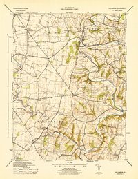
 1944 Mercersburg1944 Print · USGSFranklin County's landscape during the 1940s reveals a well-developed network of small-town institutions and mountain-side preserves. Genealogists and historians can locate specific local landmarks like Mercersburg Academy, the Blue Spring School, and Heinbaugh Lime.
 - 1944 Map of Williamson
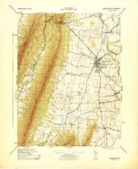
 1944 Williamson1944 Print · USGSFranklin County's rural landscape is captured here during the mid-forties, showing the township life of Antrim and Montgomery. Genealogists can locate family-named schoolhouses and academies like the Welsh Run Academy and Pinefield School, or trace the rail line through Williamson.5 unique versions available
 - 1944 Map of Williamsport, 1959 Print
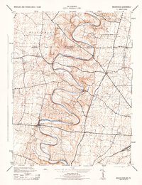
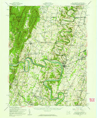 1944 Williamsport1959 Print · USGSMaryland and West Virginia meet along the winding Potomac in the mid-1940s, a landscape defined by river trade and mountain ridges. Genealogists and historians can trace the Chesapeake and Ohio Canal past McCoys Ferry, Cushwa Mill, and the Stonewall Jackson Monument.2 unique versions available
 - 1948 Map of Baltimore
 1948 Baltimore1948 Print · USGSMaryland and Pennsylvania crossroads are captured in the late 1940s, showing a landscape defined by historic rail lines and major military installations. Genealogists can trace family connections in Gettysburg, Westminster, and near the U.S. Naval Academy in Annapolis.2 unique versions available
End of results
Showing maps 1-10 of 10
Top cities near Montgomery Township
- Hagerstown historical maps
- Chambersburg historical maps
- Halfway historical maps
- Robinwood historical maps
- Fountainhad-Orchard Hills historical maps
- Greencastle historical maps
See more
Top neighborhoods of Montgomery Township
- Bino historical maps
- Claylick historical maps
- Kasiesville historical maps
- Lenwood Heights historical maps
- Shimpstown historical maps
- Nova historical maps
See more
Frequently asked questions
- What are the different types of historical maps available for Montgomery Township?
- What is the oldest map of Montgomery Township?
- Where can I purchase historical maps of Montgomery Township for my home or office?
- Where can I download high-res historical maps of Montgomery Township?
- Are there historical topographic maps available for Montgomery Township?
- Is there historical aerial imagery available for Montgomery Township?
- Where are historical maps of Montgomery Township sourced from?