1990s Maps of Montgomery Township, Pennsylvania
Explore 2 historic maps of Montgomery Township from the 1990s. These maps offer a rare glimpse into what life looked like during the 1990s — showing old roads, neighborhoods, homes, and landmarks that have changed or disappeared over time.
Whether you're researching your family's past, planning a metal detecting trip, or studying how Montgomery Township's landscape evolved across the 1990s, these high-resolution maps are a powerful tool for exploring the history of this region.
- Focus on a specific era: All maps on this page are from the 1990s, giving you a focused view of this time period.
- See what’s changed: Compare century-old streets, trails, and buildings to today's modern landscape using overlays and satellite layers.
- Research with precision: Use these maps for genealogy, historical research, land use analysis, or educational projects.
- View, download, or print: Maps are fully viewable online in high resolution, and can be downloaded or printed for your own records.
Start exploring Montgomery Township's history through authentic maps from the 1990s. This is your window into the past.
Montgomery Township, PA maps
(2)- 1990 Map of Mercersburg, 1995 Print
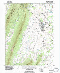 1990 Mercersburg1995 Print · USGSThe Mercersburg valley in the early nineties is a landscape of mountain ridges and historic education hubs. Researchers can trace the legacy of local families through landmarks like Spring Grove Cem, the Old Railroad Grade, and Mercersburg Academy.
 - 1990 Map of Williamson, 1995 Print
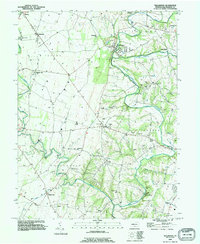 1990 Williamson1995 Print · USGSFranklin County's rolling hills and limestone creeks are captured here in the early nineties, showing a landscape defined by historic settlements and water. Genealogists can trace family connections at Montgomery Ch, the Martins Mill Covered Bridge, and the community at Welsh Run.
End of results
Showing maps 1-2 of 2
Top cities near Montgomery Township
- Hagerstown historical maps
- Chambersburg historical maps
- Halfway historical maps
- Robinwood historical maps
- Fountainhad-Orchard Hills historical maps
- Greencastle historical maps
See more
Top neighborhoods of Montgomery Township
- Bino historical maps
- Claylick historical maps
- Kasiesville historical maps
- Lenwood Heights historical maps
- Shimpstown historical maps
- Nova historical maps
See more
Frequently asked questions
- What are the different types of historical maps available for Montgomery Township?
- What is the oldest map of Montgomery Township?
- Where can I purchase historical maps of Montgomery Township for my home or office?
- Where can I download high-res historical maps of Montgomery Township?
- Are there historical topographic maps available for Montgomery Township?
- Is there historical aerial imagery available for Montgomery Township?
- Where are historical maps of Montgomery Township sourced from?