1990s Maps of Quincy Township, Pennsylvania
Explore 3 historic maps of Quincy Township from the 1990s. These maps offer a rare glimpse into what life looked like during the 1990s — showing old roads, neighborhoods, homes, and landmarks that have changed or disappeared over time.
Whether you're researching your family's past, planning a metal detecting trip, or studying how Quincy Township's landscape evolved across the 1990s, these high-resolution maps are a powerful tool for exploring the history of this region.
- Focus on a specific era: All maps on this page are from the 1990s, giving you a focused view of this time period.
- See what’s changed: Compare century-old streets, trails, and buildings to today's modern landscape using overlays and satellite layers.
- Research with precision: Use these maps for genealogy, historical research, land use analysis, or educational projects.
- View, download, or print: Maps are fully viewable online in high resolution, and can be downloaded or printed for your own records.
Start exploring Quincy Township's history through authentic maps from the 1990s. This is your window into the past.
Quincy Township, PA maps
(3)- 1990 Map of Waynesboro, 1995 Print
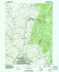 1990 Waynesboro1995 Print · USGSIn the 1990s, the area around Waynesboro maintained its balance of valley agriculture and forested mountain slopes. Genealogists can trace family names at Nunnery Cem, Quinsonia, and the Penn State University Mont Alto Campus.
 - 1990 Map of Greencastle, 1995 Print
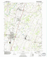 1990 Greencastle1995 Print · USGSGreencastle and the surrounding Cumberland Valley townships appear in the 1990s as a blend of growing residential hubs and deep-rooted rural industry. Researchers can trace historic family locations at Browns Mill Cem, locate the Cumberland Valley Airstrip, and explore the legacy of Browns Mill.
 - 1990 Map of Iron Springs, 1995 Print
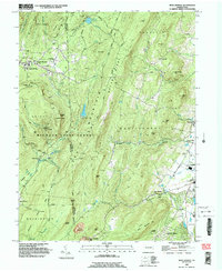 1990 Iron Springs1995 Print · USGSSouth Mountain and the wooded reaches of Michaux State Forest are captured here in the early nineties. Researchers can trace rural landmarks like Mt Carmel Ch, the South Mountain Restoration Center, and the historic Iron Springs area.2 unique versions available
End of results
Showing maps 1-3 of 3
Top cities near Quincy Township
- Hagerstown historical maps
- Chambersburg historical maps
- Halfway historical maps
- Waynesboro historical maps
- Robinwood historical maps
- Thurmont historical maps
See more
Top neighborhoods of Quincy Township
- Biesecker Gap historical maps
- Fairview historical maps
- Five Forks historical maps
- Fox Hill historical maps
- Greendale historical maps
- Knepper historical maps
See more
Frequently asked questions
- What are the different types of historical maps available for Quincy Township?
- What is the oldest map of Quincy Township?
- Where can I purchase historical maps of Quincy Township for my home or office?
- Where can I download high-res historical maps of Quincy Township?
- Are there historical topographic maps available for Quincy Township?
- Is there historical aerial imagery available for Quincy Township?
- Where are historical maps of Quincy Township sourced from?