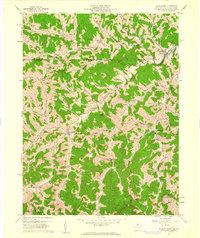
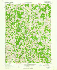
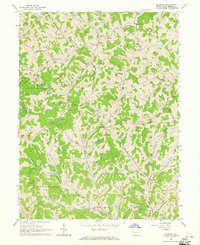
1900s (20th Century) Maps of Wayne Township, Pennsylvania
Explore 18 historic maps of Wayne Township from the 1900s (20th Century). These maps offer a rare glimpse into what life looked like during the 1900s — showing old roads, neighborhoods, homes, and landmarks that have changed or disappeared over time.
Whether you're researching your family's past, planning a metal detecting trip, or studying how Wayne Township's landscape evolved across the 1900s, these high-resolution maps are a powerful tool for exploring the history of this region.
- Focus on a specific era: All maps on this page are from the 1900s, giving you a focused view of this time period.
- See what’s changed: Compare century-old streets, trails, and buildings to today's modern landscape using overlays and satellite layers.
- Research with precision: Use these maps for genealogy, historical research, land use analysis, or educational projects.
- View, download, or print: Maps are fully viewable online in high resolution, and can be downloaded or printed for your own records.
Start exploring Wayne Township's history through authentic maps from the 1900s. This is your window into the past.
Wayne Township, PA maps
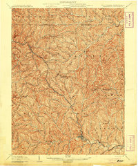
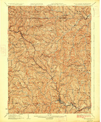
(18)- 1901 Map of Waynesburg, 1958 Print
 1901 Waynesburg1958 Print · USGSGreene County at the start of the twentieth century shows a landscape of deep valleys and rising townships connected by the South Fork of Tenmile Creek. Genealogists can trace family names through landmarks like Rees Mill, Gump, and the dual settlement of Kirby Newtown.
 - 1904 Map of Blacksville
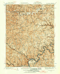
 1904 Blacksville1904 Print · USGSThe West Virginia and Pennsylvania border comes alive in this survey from the early twentieth century. Researchers can trace the river economy along the Monongahela at Lock No. 13 or locate rural homesteads near Fairview Amos P.O. and Blacksville.3 unique versions available
 - 1904 Map of Waynesburg
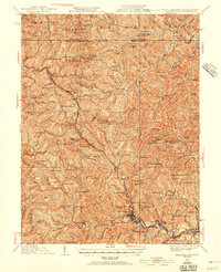
 1904 Waynesburg1904 Print · USGSGreene County was a landscape of deeply carved creek valleys and rural crossroads at the start of the twentieth century. Genealogists and local historians can trace early property settings near Waynesburg, Rees Mill, and the riverside borough of Rices Landing.5 unique versions available
 - 1905 Map of Mannington
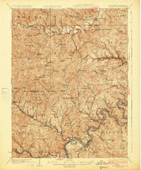
 1905 Mannington1905 Print · USGSThe West Virginia-Pennsylvania borderlands are captured here at the start of the twentieth century, showing a landscape defined by deep ridges and rail-side commerce. Genealogists can trace family roots through locations like Hundred Church, Wadestown, and Brave P.O. along the state line.2 unique versions available
 - 1905 Map of Rogersville
 1905 Rogersville1905 Print · USGSGreene and Washington counties are documented here at the turn of the century as a maze of ridge-and-valley settlements. Genealogists can trace early homesteads and commerce hubs like Harveys P.O. Graysville, Simpson Store, and Ryerson Station.4 unique versions available
 - 1923 Map of Blacksville, 1956 Print
 1923 Blacksville1956 Print · USGSMonongalia and Marion counties appear here during the early twentieth century as the coal and rail economy began to reshape the rural landscape. Researchers can find numerous family landmarks, from Town School and Olive Church to the industrial works at Montana Mines.
 - 1923 Map of Mannington, 1956 Print
 1923 Mannington1956 Print · USGSMannington and the surrounding hollows of Marion and Monongalia counties appear here in the early twenties as a dense network of rural life. Genealogists can trace family footprints through numerous small landmarks like Blackshire Chapel, Efaw Knob, and Glover Gap.
 - 1925 Map of Blacksville
 1925 Blacksville1925 Print · USGSMonongalia and Marion Counties are shown in the mid-1920s, a period when rural life centered on a vast network of neighborhood schools and churches. Genealogists can trace family roots through specific landmarks like Stumptown School, Montana Mines, and Monumental Church.4 unique versions available
 - 1926 Map of Mannington
 1926 Mannington1926 Print · USGSNorthern West Virginia and the Pennsylvania borderlands are shown here in the 1920s during a period of steady rural growth. Genealogists can trace family names through dozens of upland sites like Saint Cloud, Glover Gap, and the uniquely named The Little Red Church.2 unique versions available
 - 1949 Map of Clarksburg
 1949 Clarksburg1949 Print · USGSThe upper Ohio River valley and the industrial heart of West Virginia come into focus during this post-war period. Genealogists and researchers can trace the rail corridors of the Baltimore and Ohio and locate centers like Fairmont, Grafton, and Waynesburg.
 - 1956 Map of Clarksburg, 1966 Print
 1956 Clarksburg1966 Print · USGSThe Ohio River valley and the industrial heart of West Virginia are seen here in the mid-1950s as rail and river commerce thrived. Researchers can trace historic transport lines like the Baltimore and Ohio RR and locate ancestral homes in Clarksburg, Moundsville, or Parkersburg.2 unique versions available
 - 1958 Map of Wadestown, 1961 Print
 1958 Wadestown1961 Print · USGSMonongalia County's rugged ridges and rural hollows are captured here in the late fifties. Genealogists can trace family names at the New Mt Tabor Cemetery, visit the Crossroads Sch, or locate the historic Covered Bridge near Jollytown.4 unique versions available
 - 1958 Map of Blacksville, 1962 Print
 1958 Blacksville1962 Print · USGSMonongalia County's rugged gas fields and rural crossroads are captured here in the late fifties. Researchers can locate family landmarks like Tennant Cem, the Drive-in Theater near Blacksville, and small settlements like Mooresville and Daybrook.4 unique versions available
 - 1961 Map of Clarksburg
 1961 Clarksburg1961 Print · USGSThe mid-century industrial and river landscapes of West Virginia and Ohio are detailed here, centered on the Ohio River. Researchers can trace the Baltimore and Ohio rail lines connecting towns like Parkersburg, Clarksburg, and Monongah.
 - 1961 Map of Oak Forest, 1963 Print
 1961 Oak Forest1963 Print · USGSGreene County’s rural character is captured here in the early 1960s, showing a landscape of hollows and ridge-top settlements. Genealogists can trace family landmarks and rural hubs like Oak Forest, Spraggs, and the Shannon Run Sch.4 unique versions available
 - 1964 Map of Holbrook, 1965 Print
 1964 Holbrook1965 Print · USGSGreene County's ridge-and-valley landscape is shown in the mid-1960s as gas extraction and rural farming shaped the local economy. Researchers can trace family roots at Higgins Cem, Pine Bank, and small country parishes like Bethany Ch.2 unique versions available
 - 1984 Map of Moundsville
 1984 Moundsville1984 Print · USGSThe Ohio River valley and the Appalachian interior meet in the mid-eighties as a hub of rail and river commerce. Genealogists and historians can trace the development of river towns like New Martinsville, inland hubs like Waynesburg, and the path of the B & O RR.
 - 1988 Map of Clarksburg, 1989 Print
 1988 Clarksburg1989 Print · USGSThe central Appalachians are documented in detail during the late eighties, showing the industrial and river-based economies of West Virginia, Ohio, and Pennsylvania. Researchers can trace historic rail routes like the B & O RR and locate river towns from St Marys to Parkersburg.
End of results
Showing maps 1-18 of 18
Top cities near Wayne Township
- Waynesburg historical maps
- Dunkard Township historical maps
- East Finley Township historical maps
- Cassville historical maps
- West Finley Township historical maps
- Grant Town historical maps
See more
Top neighborhoods of Wayne Township
- Brave historical maps
- Shamrock historical maps
- Spraggs historical maps
- Rush Crossroads historical maps
- Kuhntown historical maps
Frequently asked questions
- What are the different types of historical maps available for Wayne Township?
- What is the oldest map of Wayne Township?
- Where can I purchase historical maps of Wayne Township for my home or office?
- Where can I download high-res historical maps of Wayne Township?
- Are there historical topographic maps available for Wayne Township?
- Is there historical aerial imagery available for Wayne Township?
- Where are historical maps of Wayne Township sourced from?