1960s Maps of Henderson Township, Pennsylvania
Explore 5 historic maps of Henderson Township from the 1960s. These maps offer a rare glimpse into what life looked like during the 1960s — showing old roads, neighborhoods, homes, and landmarks that have changed or disappeared over time.
Whether you're researching your family's past, planning a metal detecting trip, or studying how Henderson Township's landscape evolved across the 1960s, these high-resolution maps are a powerful tool for exploring the history of this region.
- Focus on a specific era: All maps on this page are from the 1960s, giving you a focused view of this time period.
- See what’s changed: Compare century-old streets, trails, and buildings to today's modern landscape using overlays and satellite layers.
- Research with precision: Use these maps for genealogy, historical research, land use analysis, or educational projects.
- View, download, or print: Maps are fully viewable online in high resolution, and can be downloaded or printed for your own records.
Start exploring Henderson Township's history through authentic maps from the 1960s. This is your window into the past.
Henderson Township, PA maps
(5)- 1964 Map of Pittsburgh
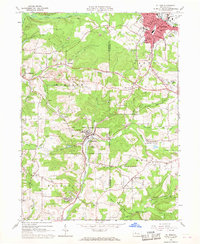
 1964 Pittsburgh1964 Print · USGSWestern Pennsylvania in the late fifties and early sixties shows a landscape of powerful river industries and expanding highways. Genealogists and historians can trace the rail corridors of the Pennsylvania RR through industrial hubs like Johnstown, Altoona, and Nanty Glo.
 - 1966 Map of Du Bois, 1968 Print
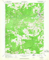
 1966 Du Bois1968 Print · USGSThe Jefferson County coalfields are captured in the mid-1960s, showing a landscape defined by surface mining and rail transit. Researchers can trace the legacy of mining towns from Sykesville to Rathmel and locate family burial sites at Rumbarger Cem or Prospect Cem.6 unique versions available
 - 1966 Map of Reynoldsville, 1968 Print
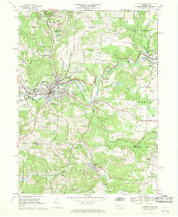
 1966 Reynoldsville1968 Print · USGSJefferson County mining communities thrive during the late sixties as rail lines connect rural outposts. Genealogists can trace family names at St Marys Cem, identify the streets of Reynoldsville, or locate the Tipple Mine near Panic.4 unique versions available
 - 1968 Map of Punxsutawney, 1970 Print
 1968 Punxsutawney1970 Print · USGSPunxsutawney and its surrounding coal-mining townships are captured in the late sixties, showing a landscape defined by rail lines and deep-valley settlements. Genealogists can locate family sites at Circle Hill Cem, Steffy Chapel, and Gobblers Knob.6 unique versions available
 - 1968 Map of Mc Gees Mills, 1971 Print
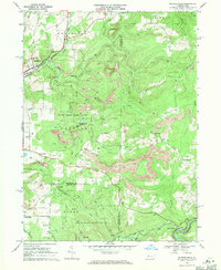 1968 Mc Gees Mills1971 Print · USGSThe West Branch Susquehanna River valley in the late sixties reveals a landscape shaped by coal mining, rail transport, and small upland farming. Researchers can locate the Covered Bridge at McGees Mills, the Punxsutawney Reservoir, and rural sites like Mt Pleasant Ch.5 unique versions available
End of results
Showing maps 1-5 of 5
Top cities near Henderson Township
- Sandy Township historical maps
- DuBois historical maps
- Punxsutawney historical maps
- Winslow historical maps
- Reynoldsville historical maps
- Warsaw Township historical maps
See more
Top neighborhoods of Henderson Township
Frequently asked questions
- What are the different types of historical maps available for Henderson Township?
- What is the oldest map of Henderson Township?
- Where can I purchase historical maps of Henderson Township for my home or office?
- Where can I download high-res historical maps of Henderson Township?
- Are there historical topographic maps available for Henderson Township?
- Is there historical aerial imagery available for Henderson Township?
- Where are historical maps of Henderson Township sourced from?