1960s Maps of Warsaw Township, Pennsylvania
Explore 4 historic maps of Warsaw Township from the 1960s. These maps offer a rare glimpse into what life looked like during the 1960s — showing old roads, neighborhoods, homes, and landmarks that have changed or disappeared over time.
Whether you're researching your family's past, planning a metal detecting trip, or studying how Warsaw Township's landscape evolved across the 1960s, these high-resolution maps are a powerful tool for exploring the history of this region.
- Focus on a specific era: All maps on this page are from the 1960s, giving you a focused view of this time period.
- See what’s changed: Compare century-old streets, trails, and buildings to today's modern landscape using overlays and satellite layers.
- Research with precision: Use these maps for genealogy, historical research, land use analysis, or educational projects.
- View, download, or print: Maps are fully viewable online in high resolution, and can be downloaded or printed for your own records.
Start exploring Warsaw Township's history through authentic maps from the 1960s. This is your window into the past.
Warsaw Township, PA maps
(4)- 1966 Map of Hazen, 1968 Print
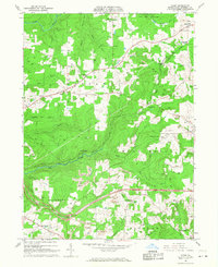 1966 Hazen1968 Print · USGSJefferson County’s coal and rail landscape is captured here in the mid-1960s, showing a region defined by industrial extraction and small rural hamlets. Genealogists and local historians can trace family roots through sites like Warsaw Sch, Sugar Hill Station, and the rural community of Hormtown.4 unique versions available
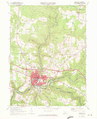
 - 1967 Map of Sigel, 1971 Print
 1967 Sigel1971 Print · USGSJefferson and Forest counties meet along the Clarion River in the late sixties, where timber and energy production shaped the landscape. Genealogists can locate family landmarks like Mt Tabor Cem, the Edeburn Ch, and the remote Heitiff Pumping Station.5 unique versions available
 - 1969 Map of Munderf, 1972 Print
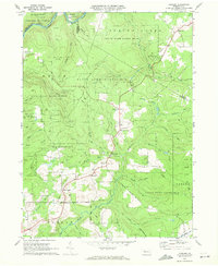 1969 Munderf1972 Print · USGSJefferson County was a landscape of dense timber and energy extraction in the late sixties, where state forests met active gas fields. Genealogists and researchers can trace local families through small settlements like Munderf, the remote Munderf Cem, and old crossroads at Schoffner Corner and Dutch Hill.3 unique versions available
 - 1969 Map of Brookville, 1972 Print
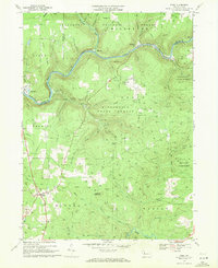
 1969 Brookville1972 Print · USGSJefferson County's river valleys and rail corridors are captured in detail during the late sixties. Researchers can trace family history through local landmarks like St Marys Cemetery, the County Home, and the old Brookville High School.3 unique versions available
End of results
Showing maps 1-4 of 4
Top cities near Warsaw Township
- Sandy Township historical maps
- DuBois historical maps
- Brookville historical maps
- Reynoldsville historical maps
- Brockway historical maps
- Sykesville historical maps
See more
Top neighborhoods of Warsaw Township
- Richardsville historical maps
- Reitz historical maps
- Allens Mills historical maps
- Egypt historical maps
- Hazen historical maps
- North Sulger historical maps
Frequently asked questions
- What are the different types of historical maps available for Warsaw Township?
- What is the oldest map of Warsaw Township?
- Where can I purchase historical maps of Warsaw Township for my home or office?
- Where can I download high-res historical maps of Warsaw Township?
- Are there historical topographic maps available for Warsaw Township?
- Is there historical aerial imagery available for Warsaw Township?
- Where are historical maps of Warsaw Township sourced from?