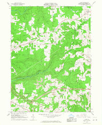
1966 Map of Hazen
USGS Topo · Published 1968About this map
Extensive industrial and natural resources define the landscape of Jefferson County in the mid-1960s, where the winding corridors of the Pittsburg and Shawmut railroad connect coal-rich ridges and quiet settlements. The terrain is marked by numerous Strip Mine operations that flank the drainage basins of Fivemile Run and Little Mill Creek. In the north, State Game Lands No 54 provides a contrast of undeveloped woodland near Sugar Hill, while the Du Bois-Jefferson County Airport represents the region's mid-century infrastructure growth.
Find a feature on this map
37 named features on this map. Tap any name to fly to it.
Don’t see what you’re looking for? This feature index may not catch every label — zoom into the map to look around manually.
Map Details
Editions of this 1966 Hazen Map
4 editions found
Other maps of this area

1918 · Loleta
USGS Topo · 1:62,500

1922 · Du Bois
USGS Topo · 1:62,500

1924 · Du Bois
USGS Topo · 1:62,500

1924 · Brookville
USGS Topo · 1:62,500

1926 · Brookville
USGS Topo · 1:62,500

1936 · Marienville
USGS Topo · 1:48,000

1940 · Hallton
USGS Topo · 1:48,000

1941 · Marienville
USGS Topo · 1:62,500

1943 · Hallton
USGS Topo · 1:62,500

1944 · Du Bois
USGS Topo · 1:62,500
Featured Places
- Warsaw Township, PA
- Pine Creek Township, PA
- Polk Township, PA
- North Sulger, Warsaw Township
- Sugar Hill, Snyder Township