
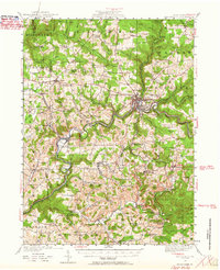
1924 Map of Brookville
USGS Topo · Published 1957About this map
Brookville serves as the regional hub at the confluence of the North Fork and Sandy Creek, where the local topography is defined by the deep carving of Redbank Creek. In the early 1920s, the landscape across Jefferson County was densely dotted with rural infrastructure, particularly one-room schoolhouses like the Hazel Dell School, Oaks School, and Beech Hollow School. These small institutions, along with numerous settlements such as Summerville, Worthville, and Knoxdale, highlight a period of decentralized community life before the consolidation of rural districts.
Find a feature on this map
107 named features on this map. Tap any name to fly to it.
Don’t see what you’re looking for? This feature index may not catch every label — zoom into the map to look around manually.
Map Details
Editions of this 1924 Brookville Map
2 editions found
Other maps of this area

1901 · Rural Valley
USGS Topo · 1:62,500

1903 · Rural Valley
USGS Topo · 1:62,500

1906 · Clarion
USGS Topo · 1:62,500

1906 · Punxsutawney
USGS Topo · 1:62,500

1907 · Clarion
USGS Topo · 1:62,500

1909 · Smicksburg
USGS Topo · 1:62,500

1918 · Loleta
USGS Topo · 1:62,500

1922 · Tionesta
USGS Topo · 1:62,500

1922 · Du Bois
USGS Topo · 1:62,500

1924 · Du Bois
USGS Topo · 1:62,500