1940s Maps of Fell Township, Pennsylvania
Explore 10 historic maps of Fell Township from the 1940s. These maps offer a rare glimpse into what life looked like during the 1940s — showing old roads, neighborhoods, homes, and landmarks that have changed or disappeared over time.
Whether you're researching your family's past, planning a metal detecting trip, or studying how Fell Township's landscape evolved across the 1940s, these high-resolution maps are a powerful tool for exploring the history of this region.
- Focus on a specific era: All maps on this page are from the 1940s, giving you a focused view of this time period.
- See what’s changed: Compare century-old streets, trails, and buildings to today's modern landscape using overlays and satellite layers.
- Research with precision: Use these maps for genealogy, historical research, land use analysis, or educational projects.
- View, download, or print: Maps are fully viewable online in high resolution, and can be downloaded or printed for your own records.
Start exploring Fell Township's history through authentic maps from the 1940s. This is your window into the past.
Fell Township, PA maps
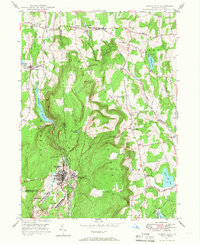
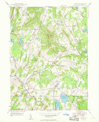
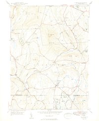
(10)- 1943 Map of Honesdale
 1943 Honesdale1943 Print · USGSThe northern Poconos and the Upper Delaware River valley appear here during the early war years, showing a network of mountain hamlets and riverfront rail towns. Genealogists can trace family roots through numerous remote institutions like Kingsbury Hill Church, Peakville P O, and the Hiawatha School.
 - 1946 Map of Forest City, 1966 Print
 1946 Forest City1966 Print · USGSPost-war Susquehanna County is captured here as the coal and rail era transitions into a new chapter. Genealogists can trace family lines through Forest City and find rural landmarks like the Curtis Valley Sch or Maple Grove Cem.3 unique versions available
 - 1946 Map of Carbondale, 1966 Print
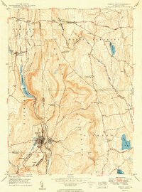
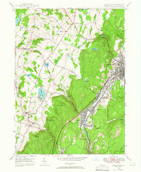 1946 Carbondale1966 Print · USGSThe Lackawanna River valley hummed with industry and rail activity in the years following the war. Researchers can trace the dual rail paths of the New York Ontario and Western and Delaware and Hudson through Carbondale, Jermyn, and Mayfield.3 unique versions available
 - 1946 Map of Waymart, 1968 Print
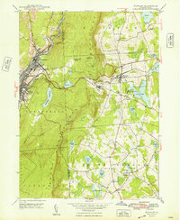
 1946 Waymart1968 Print · USGSWayne and Lackawanna counties showcase a mix of industrial coal valley life and rural highland settlements in the mid-1940s. Genealogists and historians can trace family roots through the Russian Monastery, Old Canaan Cem, and the Fairview State Hospital.4 unique versions available
 - 1946 Map of Clifford, 1971 Print
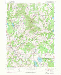 1946 Clifford1971 Print · USGSSusquehanna and Lackawanna counties come together in this mid-century survey of the high country around Elk Hill. Genealogists and local historians can trace the Old Newburg Turnpike and locate family burial grounds like Burdick Cem and Lyons Street Cem.2 unique versions available
 - 1948 Map of Clifford
 1948 Clifford1948 Print · USGSThe rolling uplands of Susquehanna County are captured here in the late 1940s, centered on the high peaks of Elk Hill. Genealogists can trace family names through many rural burial grounds like Willow View Cem and the crossroads at Burdick Corners.
 - 1948 Map of Waymart
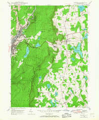
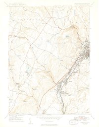
 1948 Waymart1948 Print · USGSThe Lackawanna River valley and the eastern plateaus are shown in the late 1940s, just as the regional rail network remained at its peak. Researchers can trace the Erie Railroad through Carbondale and locate landmarks like the Russian Monastery or South Clinton Sch.2 unique versions available
 - 1949 Map of Carbondale
 1949 Carbondale1949 Print · USGSThe industrial Lackawanna Valley is shown in detail during the late 1940s, tracing the river-and-rail corridor through Carbondale and Jermyn. Researchers can locate family landmarks like Scott High Sch, Mt Carmel Ch, and the Mid Valley Airport.2 unique versions available
 - 1949 Map of Forest City
 1949 Forest City1949 Print · USGSIn the decade following the war, this Pennsylvania landscape shows the enduring rail-and-river network of the Moosic Mountains. Genealogists and historians can trace family-named landmarks and rural hubs such as Pleasant Mount, Uniondale, and the St Peter and Paul Ch.2 unique versions available
 - 1949 Map of Clifford
 1949 Clifford1949 Print · USGSSusquehanna County in the late 1940s is a landscape of high ridges and rural hamlets linked by the Old Newburg Turnpike. Researchers can trace old family sites and crossroads communities like Burdick Corners, Birchtown, and Welch Hill Ch.2 unique versions available
End of results
Showing maps 1-10 of 10
Top cities near Fell Township
- Scranton historical maps
- Dunmore historical maps
- Carbondale historical maps
- Blakely historical maps
- Archbald historical maps
- Dickson City historical maps
See more
Top neighborhoods of Fell Township
Frequently asked questions
- What are the different types of historical maps available for Fell Township?
- What is the oldest map of Fell Township?
- Where can I purchase historical maps of Fell Township for my home or office?
- Where can I download high-res historical maps of Fell Township?
- Are there historical topographic maps available for Fell Township?
- Is there historical aerial imagery available for Fell Township?
- Where are historical maps of Fell Township sourced from?