1940s Maps of Old Forge, Lackawanna County
Explore 8 historic maps of Old Forge from the 1940s. These maps offer a rare glimpse into what life looked like during the 1940s — showing old roads, neighborhoods, homes, and landmarks that have changed or disappeared over time.
Whether you're researching your family's past, planning a metal detecting trip, or studying how Old Forge's landscape evolved across the 1940s, these high-resolution maps are a powerful tool for exploring the history of this region.
- Focus on a specific era: All maps on this page are from the 1940s, giving you a focused view of this time period.
- See what’s changed: Compare century-old streets, trails, and buildings to today's modern landscape using overlays and satellite layers.
- Research with precision: Use these maps for genealogy, historical research, land use analysis, or educational projects.
- View, download, or print: Maps are fully viewable online in high resolution, and can be downloaded or printed for your own records.
Start exploring Old Forge's history through authentic maps from the 1940s. This is your window into the past.
Old Forge, Lackawanna County maps
(8)- 1943 Map of Scranton
 1943 Scranton1943 Print · USGSNortheastern Pennsylvania’s coal and rail corridor comes to life in the 1940s, showcasing the dense urban industrial centers of the Wyoming Valley. Genealogists can locate family landmarks like the Fayette School and Locust Ridge School or trace the early paths of the DL & W and Erie railroads.
 - 1946 Map of Avoca, 1959 Print
 1946 Avoca1959 Print · USGSThe coal-rich Lackawanna Valley is shown here just after the war, as heavy industry and new aviation infrastructure transformed the landscape. Researchers can trace the extensive rail networks and local landmarks like the Consolidated Breaker, Belian Village, and Sacred Heart Cem.5 unique versions available
 - 1946 Map of Ransom, 1964 Print
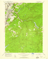
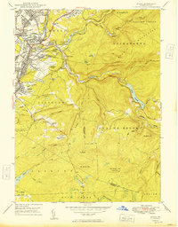
 1946 Ransom1964 Print · USGSThe Susquehanna River valley in the 1940s shows a landscape of river-bend settlements and early aviation infrastructure. Researchers can trace the Lehigh Valley rail line and locate landmarks like the Ransom-Newton State Hospital and Scranton Airport.4 unique versions available
 - 1947 Map of Scranton, 1957 Print
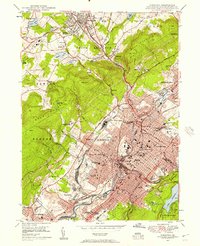 1947 Scranton1957 Print · USGSThe Lackawanna Valley in the late 1940s is a high-density industrial corridor defined by its deep coal roots and rail networks. Genealogists can locate family names at Forest Hill Cemetery, trace the early campus of Scranton University, or find vanished neighborhood landmarks like the State Oral Sch.4 unique versions available
 - 1947 Map of Pittston, 1961 Print
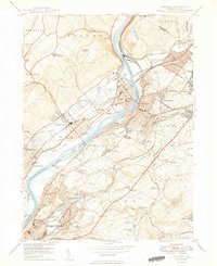
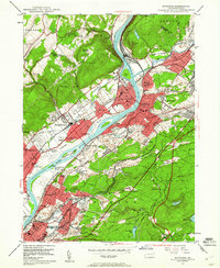 1947 Pittston1961 Print · USGSLuzerne County's industrial heartland is captured here in the late 1940s, showing the dense rail-and-river corridor of the Wyoming Valley. Genealogists can trace family roots through numerous local landmarks, including the Wyoming Monument, St Joseph Cem, and the Port Griffith Sch.4 unique versions available
 - 1949 Map of Avoca
 1949 Avoca1949 Print · USGSPost-war Luzerne and Lackawanna counties reveal a landscape of anthracite heritage and rising aviation. Trace family roots at Old Forge Cem, locate the Consolidated Breaker, or explore the rail networks around Hillside Junction.2 unique versions available
 - 1949 Map of Pittston
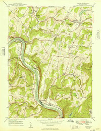
 1949 Pittston1949 Print · USGSThe Wyoming Valley industrial corridor is captured here at a post-war peak, showing the heavy rail-and-river network of the coal regions. Researchers can trace historic family landmarks from the Wyoming Monument to the Wyoming Camp Ground and St Joseph Cem.2 unique versions available
 - 1949 Map of Ransom
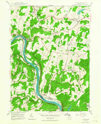
 1949 Ransom1949 Print · USGSThe Susquehanna River valley and its surrounding ridges come alive in the late 1940s, showing a landscape defined by rail and river. Genealogists can trace family names through the Newton-Ransom Sch, Post Hill Cem, and the Ransom-Newton State Hospital.
End of results
Showing maps 1-8 of 8
Frequently asked questions
- What are the different types of historical maps available for Old Forge?
- What is the oldest map of Old Forge?
- Where can I purchase historical maps of Old Forge for my home or office?
- Where can I download high-res historical maps of Old Forge?
- Are there historical topographic maps available for Old Forge?
- Is there historical aerial imagery available for Old Forge?
- Where are historical maps of Old Forge sourced from?