1990s Maps of Roaring Brook Township, Pennsylvania
Explore 5 historic maps of Roaring Brook Township from the 1990s. These maps offer a rare glimpse into what life looked like during the 1990s — showing old roads, neighborhoods, homes, and landmarks that have changed or disappeared over time.
Whether you're researching your family's past, planning a metal detecting trip, or studying how Roaring Brook Township's landscape evolved across the 1990s, these high-resolution maps are a powerful tool for exploring the history of this region.
- Focus on a specific era: All maps on this page are from the 1990s, giving you a focused view of this time period.
- See what’s changed: Compare century-old streets, trails, and buildings to today's modern landscape using overlays and satellite layers.
- Research with precision: Use these maps for genealogy, historical research, land use analysis, or educational projects.
- View, download, or print: Maps are fully viewable online in high resolution, and can be downloaded or printed for your own records.
Start exploring Roaring Brook Township's history through authentic maps from the 1990s. This is your window into the past.
Roaring Brook Township, PA maps
(5)- 1994 Map of Avoca, 1995 Print
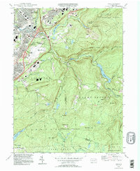 1994 Avoca1995 Print · USGSThe Lackawanna Valley at the end of the twentieth century shows a dense network of coal-country boroughs and major transportation hubs. Genealogists and historians can trace family plots in the Polish National Cem or locate neighborhoods in Old Forge and Avoca.
 - 1994 Map of Scranton, 1996 Print
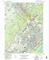 1994 Scranton1996 Print · USGSThe Lackawanna Valley at the end of the twentieth century shows a city shaped by rail and river. Researchers can trace the layout of historic neighborhoods like Providence and find local landmarks such as Steamtown National Historic Site and Forest Hill Cemetery.
 - 1994 Map of Olyphant, 1996 Print
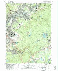 1994 Olyphant1996 Print · USGSThe Lackawanna Valley boroughs show a dense 1990s landscape of industry and community institutions just north of Scranton. Researchers can trace local heritage through numerous religious sites and landmarks like Mt Carmel Cem, Bishop O'Hara High School, and Grassy Island.
 - 1999 Map of Olyphant, 2001 Print
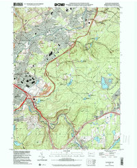 1999 Olyphant2001 Print · USGSLackawanna County's coal-valley communities and upland reservoirs are captured here in the late twentieth century. Genealogists and local historians can trace family roots through numerous sites like St Michaels Cem, Mt Carmel Cem, and the neighborhoods of Smoketown or Jessup.
 - 1999 Map of Avoca, 2002 Print
 1999 Avoca2002 Print · USGSThe Lackawanna River valley near the turn of the millennium shows a landscape defined by heavy transit and industrial roots. Trace the footprints of Belin Village and Spike Island alongside the Wilkes-Barre Scranton Intl Airport.
End of results
Showing maps 1-5 of 5
Top cities near Roaring Brook Township
- Scranton historical maps
- Dunmore historical maps
- Plains Township historical maps
- Carbondale historical maps
- Old Forge historical maps
- Pittston historical maps
See more
Top neighborhoods of Roaring Brook Township
- Brookhurst Estates historical maps
- Olwen Heights historical maps
- Crestwood historical maps
- Birchwood Estates historical maps
- Elmbrook Terrace historical maps
- Summit Woods historical maps
Frequently asked questions
- What are the different types of historical maps available for Roaring Brook Township?
- What is the oldest map of Roaring Brook Township?
- Where can I purchase historical maps of Roaring Brook Township for my home or office?
- Where can I download high-res historical maps of Roaring Brook Township?
- Are there historical topographic maps available for Roaring Brook Township?
- Is there historical aerial imagery available for Roaring Brook Township?
- Where are historical maps of Roaring Brook Township sourced from?