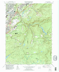
1994 Map of Avoca
USGS Topo · Published 1995About this map
The Lackawanna River corridor anchors this 1990s landscape, illustrating the industrial and residential density of the anthracite region north of Scranton. Settlements like Old Forge, Duryea, and Avoca crowd the valley, defined by tight street grids and legacy infrastructure like the Conrail lines. The high-capacity footprint of the Wilkes-Barre Scranton Intl Airport sits as a massive plateau above Glendale, contrasting with the complex topography of the Moosic Mountains to the east.
Find a feature on this map
68 named features on this map. Tap any name to fly to it.
Don’t see what you’re looking for? This feature index may not catch every label — zoom into the map to look around manually.
Map Details
Editions of this 1994 Avoca Map
This is the sole edition of this map. No revisions or reprints were ever made.
Other maps of this area

1889 · Scranton
USGS Topo · 1:62,500

1891 · Wilkesbarre
USGS Topo · 1:62,500

1891 · Scranton
USGS Topo · 1:62,500

1893 · Pittston
USGS Topo · 1:62,500

1893 · Scranton
USGS Topo · 1:62,500

1894 · Wilkesbarre
USGS Topo · 1:62,500

1922 · Stoddartsville
USGS Topo · 1:62,500

1924 · Stoddartsville
USGS Topo · 1:62,500

1943 · Scranton
USGS Topo · 1:125,000

1943 · Stoddartsville
USGS Topo · 1:62,500