
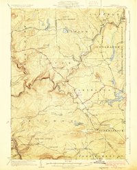
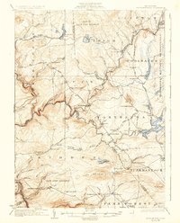
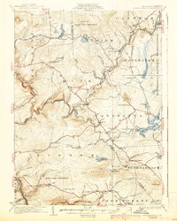
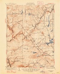
1924 Map of Stoddartsville
USGS Topo · Published 1924About this map
The Lehigh River snakes through the center of this 1920s topography, marking the boundaries between several counties and townships. Small villages and crossroads such as Stoddartsville, Blakeslee, and Thornhurst appear as concentrated pockets of activity along the winding Wilkes-Barre and Easton Road. The map documents a rural landscape transitioning toward preservation and recreation, with the Tobyhanna Military Reservation dominating the northeastern corner and a State Game Preserve established in the north.
Find a feature on this map
92 named features on this map. Tap any name to fly to it.
Don’t see what you’re looking for? This feature index may not catch every label — zoom into the map to look around manually.
Map Details
Editions of this 1924 Stoddartsville Map
5 editions found
Other maps of this area

1889 · Scranton
USGS Topo · 1:62,500

1889 · Hazleton
USGS Topo · 1:62,500

1891 · Wilkesbarre
USGS Topo · 1:62,500

1891 · Hazleton
USGS Topo · 1:62,500

1891 · Scranton
USGS Topo · 1:62,500

1893 · Hazleton
USGS Topo · 1:62,500

1893 · Pittston
USGS Topo · 1:62,500

1893 · Scranton
USGS Topo · 1:62,500

1894 · Wilkesbarre
USGS Topo · 1:62,500

1914 · Wind Gap
USGS Topo · 1:62,500
Featured Places
- Clifton Township, PA
- Thornhurst Township, PA
- Kidder Township, PA
- Buck Township, PA
- Pocono Pines, Tobyhanna Township