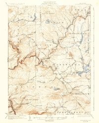
1924 Map of Stoddartsville
USGS Topo · Published 1931About this map
The Lehigh River carves a deep valley through this pocket of the Poconos, serving as a natural boundary between several townships including Kidder and Lehigh. In the early 1920s, the region was defined by a mix of emerging leisure spaces like the Pocono Lake Preserve and established mountain settlements such as Stoddartsville and Blakeslee. The presence of the Tobyhanna Military Reservation and multiple State Game Preserves indicates a landscape transitioning toward conservation and federal management.
Find a feature on this map
94 named features on this map. Tap any name to fly to it.
Don’t see what you’re looking for? This feature index may not catch every label — zoom into the map to look around manually.
Map Details
Editions of this 1924 Stoddartsville Map
5 editions found

Other maps of this area

1889 · Scranton
USGS Topo · 1:62,500

1889 · Hazleton
USGS Topo · 1:62,500

1891 · Wilkesbarre
USGS Topo · 1:62,500

1891 · Hazleton
USGS Topo · 1:62,500

1891 · Scranton
USGS Topo · 1:62,500

1893 · Hazleton
USGS Topo · 1:62,500

1893 · Pittston
USGS Topo · 1:62,500

1893 · Scranton
USGS Topo · 1:62,500

1894 · Wilkesbarre
USGS Topo · 1:62,500

1914 · Wind Gap
USGS Topo · 1:62,500
Featured Places
- Clifton Township, PA
- Thornhurst Township, PA
- Kidder Township, PA
- Buck Township, PA
- Pocono Pines, Tobyhanna Township