1960s Maps of Lancaster County, Pennsylvania
Explore 12 historic maps of Lancaster County from the 1960s. These maps offer a rare glimpse into what life looked like during the 1960s — showing old roads, neighborhoods, homes, and landmarks that have changed or disappeared over time.
Whether you're researching your family's past, planning a metal detecting trip, or studying how Lancaster County's landscape evolved across the 1960s, these high-resolution maps are a powerful tool for exploring the history of this region.
- Focus on a specific era: All maps on this page are from the 1960s, giving you a focused view of this time period.
- See what’s changed: Compare century-old streets, trails, and buildings to today's modern landscape using overlays and satellite layers.
- Research with precision: Use these maps for genealogy, historical research, land use analysis, or educational projects.
- View, download, or print: Maps are fully viewable online in high resolution, and can be downloaded or printed for your own records.
Start exploring Lancaster County's history through authentic maps from the 1960s. This is your window into the past.
Lancaster County, PA maps
(12)- 1960 Map of Newark
 1960 Newark1960 Print · USGSThe industrial heart of the Mid-Atlantic is shown at mid-century, stretching from the dense urban centers of Newark and Philadelphia to the Blue Mountain ridges. Researchers can trace historic rail lines, coastal defenses at Fort Hancock, and the riverfront growth of Trenton and Easton.3 unique versions available
 - 1961 Map of Harrisburg
 1961 Harrisburg1961 Print · USGSCentral Pennsylvania is shown at a mid-century peak of industrial and military activity, from the Susquehanna water gaps to the fertile Dutch Country. Genealogists and historians can trace the rail corridors of the Pennsylvania RR and find landmarks like Carlisle Barracks or the Anthracite Coal Fields.2 unique versions available
 - 1961 Map of Baltimore
 1961 Baltimore1961 Print · USGSMaryland and Pennsylvania are captured at a mid-century peak of industrial and military expansion. Genealogists and historians can trace rail corridors like the Western Maryland Ry or locate regional landmarks such as Camp Detrick and Kent Island.
 - 1963 Map of Wernersville
 1963 Wernersville1963 Print · USGSBerks County and Lebanon County are captured here in the early 1960s, showing a landscape defined by ridgelines and Pennsylvania Dutch heritage. Researchers can trace historic local institutions like the Bethany Orphans Home, the Jesuit College, and the winding Reading RR.
 - 1963 Map of Belair
 1963 Belair1963 Print · USGSHarford County and the Pennsylvania border are shown just after the war, when the Maryland and Pennsylvania RR still served these communities. Genealogists can locate family-named landmarks like the Broad Creek Meeting House, the Wheeler School, and St Ignatius Church.
 - 1963 Map of Middletown, 1965 Print
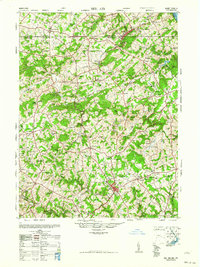
 1963 Middletown1965 Print · USGSMiddletown and the lower Susquehanna River are captured in the early sixties as military and rail infrastructure dominated the shoreline. Trace family history and local industry through Olmsted AF Base, St Peters Ch, and the many islands like Three Mile Island.5 unique versions available
 - 1964 Map of Newark
 1964 Newark1964 Print · USGSGreater New Jersey and eastern Pennsylvania appear at the peak of their industrial and rail-centered development in the mid-sixties. Genealogists and historians can trace the paths of the Pennsylvania RR, identify mid-century landmarks like CAMP KILMER, or follow the Schuylkill River through READING.2 unique versions available
 - 1964 Map of Harrisburg
 1964 Harrisburg1964 Print · USGSCentral Pennsylvania in the mid-fifties reveals a landscape shaped by ridge-and-valley geology and critical Cold War infrastructure. Researchers can trace the massive Indiantown Gap Military Reservation or the rail corridors of the Pennsylvania RR and Reading RR.
 - 1964 Map of York Haven, 1965 Print
 1964 York Haven1965 Print · USGSThe Susquehanna River corridor thrives in the mid-sixties, showcasing a landscape of riverside power generation and growing boroughs. Researchers can trace ancestral roots at Codorus Furnace or through local congregations like St Pauls Ch and Cassels Ch.5 unique versions available
 - 1964 Map of Elizabethtown, 1965 Print
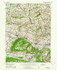
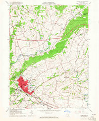 1964 Elizabethtown1965 Print · USGSElizabethtown and the surrounding Lancaster and Dauphin County townships are captured here in the mid-1960s. Genealogists and historians can trace family-named sites and rural institutions like St Calvary Ch, Mt Tunnel Cem, and the Masonic Home.4 unique versions available
 - 1964 Map of Columbia West, 1965 Print
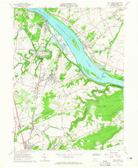
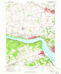 1964 Columbia West1965 Print · USGSThe Susquehanna River corridor thrives in the mid-sixties, showing the industrial and military footprint of the Marietta Air Force Station. Researchers can trace old family names and sites at Donegal Ch, Eberly Cem, and Lauxmont Farms.5 unique versions available
 - 1966 Map of Wilmington, 1968 Print
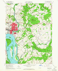
 1966 Wilmington1968 Print · USGSThe Delaware Valley and Jersey Shore are seen here in the mid-1960s, documenting a landscape of dense industrial cities and emerging coastal resorts. Researchers can trace the sprawling rail networks of the Pennsylvania Railroad or locate landmarks like Fort Dix Military Reservation and Elk Neck State Park.4 unique versions available
End of results
Showing maps 1-12 of 12
Top cities of Lancaster County
- Lancaster historical maps
- West Lampeter Township historical maps
- Ephrata historical maps
- Elizabethtown historical maps
- Columbia historical maps
- Lititz historical maps
See more
Frequently asked questions
- What are the different types of historical maps available for Lancaster County?
- What is the oldest map of Lancaster County?
- Where can I purchase historical maps of Lancaster County for my home or office?
- Where can I download high-res historical maps of Lancaster County?
- Are there historical topographic maps available for Lancaster County?
- Is there historical aerial imagery available for Lancaster County?
- Where are historical maps of Lancaster County sourced from?