2000s (21st Century) Maps of Lebanon County, Pennsylvania
Explore 16 historic maps of Lebanon County from the 2000s (21st Century). These maps offer a rare glimpse into what life looked like during the 2000s — showing old roads, neighborhoods, homes, and landmarks that have changed or disappeared over time.
Whether you're researching your family's past, planning a metal detecting trip, or studying how Lebanon County's landscape evolved across the 2000s, these high-resolution maps are a powerful tool for exploring the history of this region.
- Focus on a specific era: All maps on this page are from the 2000s, giving you a focused view of this time period.
- See what’s changed: Compare century-old streets, trails, and buildings to today's modern landscape using overlays and satellite layers.
- Research with precision: Use these maps for genealogy, historical research, land use analysis, or educational projects.
- View, download, or print: Maps are fully viewable online in high resolution, and can be downloaded or printed for your own records.
Start exploring Lebanon County's history through authentic maps from the 2000s. This is your window into the past.
Lebanon County, PA maps
(16)- 2023 Map of Palmyra, 2023 Print
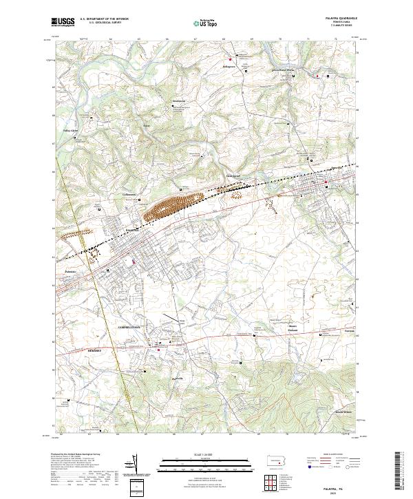 2023 Palmyra2023 Print · USGSThe Lebanon County corridor near the 2020s shows a landscape rich in religious heritage and historic transit routes. Genealogists can trace family lines through the Blauch Family Graveyard, Evergreen Cem, and the campus of Lebanon Valley College.
 - 2023 Map of Grantville, 2023 Print
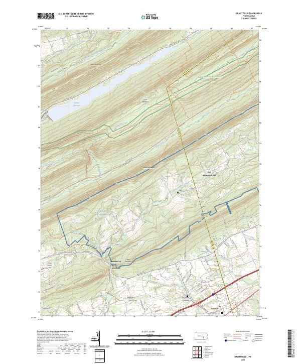 2023 Grantville2023 Print · USGSThe ridges of Dauphin and Lebanon counties are captured here in the early twenty-first century, showing the intersection of military lands and mountain recreation. Researchers can locate family sites at Old Hanover Presbyterian Churchyard or trace the Stony Valley Railroad Grade Trl.
 - 2023 Map of Elizabethtown, 2023 Print
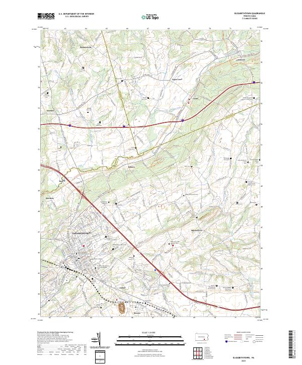 2023 Elizabethtown2023 Print · USGSThe crossroads of Lancaster and Dauphin counties come into focus in this recent survey of the area's deep-rooted settlements. Genealogists can trace hundreds of family names across dozens of sites like the Herr Gingrich Reider Graveyard and Brandt Farm Cem.
 - 2023 Map of Pine Grove, 2023 Print
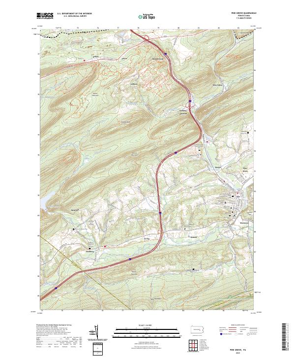 2023 Pine Grove2023 Print · USGSThe Swatara Creek valley comes alive in this contemporary look at Schuylkill County's ridges and rural crossroads. Local historians can trace family names at the Haldeman Family Cem or locate the old landing at Fairview Farm Airfield.
 - 2023 Map of Indiantown Gap, 2023 Print
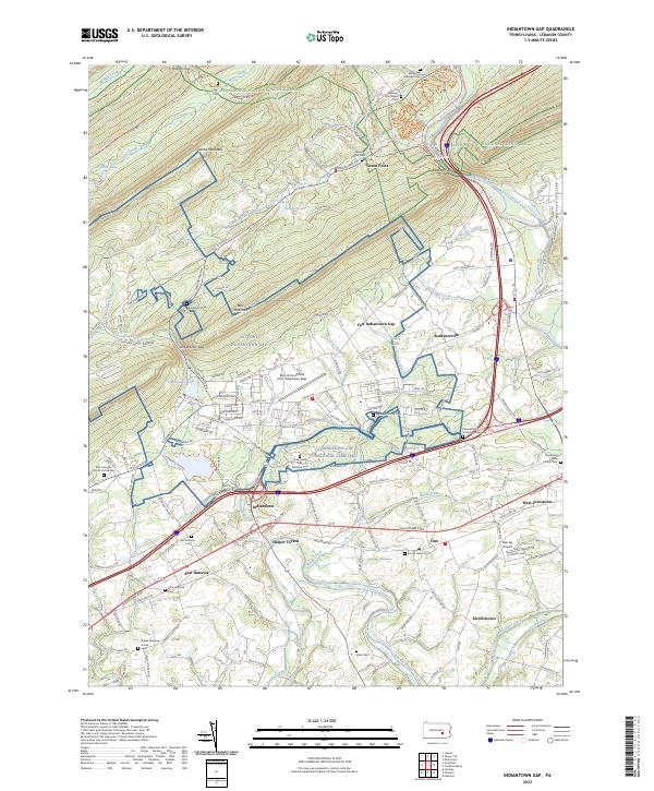 2023 Indiantown Gap2023 Print · USGSThe military installations and historic gaps of Lebanon County come into focus in the early 2020s, revealing a landscape shaped by the Union Canal and the Appalachian National Scenic Trail. Genealogists can locate family sites at Moonshine Cemetery or trace the old roads connecting Harper Tavern and Bordnersville.
 - 2023 Map of Bethel, 2023 Print
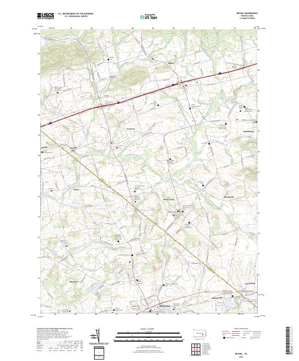 2023 Bethel2023 Print · USGSThe Berks and Lebanon County borderlands are captured here in a detailed survey of Pennsylvania’s Dutch Country. Genealogists can locate numerous family-named landmarks and churchyards, including Schmehl Farm Cem, Ziegler Family Cem, and the historic Union Canal.
 - 2023 Map of Richland, 2023 Print
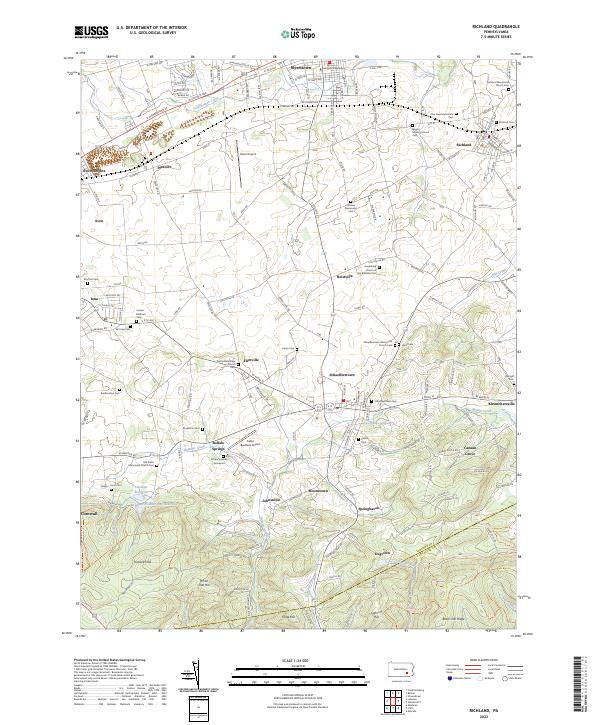 2023 Richland2023 Print · USGSThe Lebanon County countryside is revealed in the early twenty-first century, showing a landscape defined by traditional Mennonite settlements and the wooded ridges of the Furnace Hills. Researchers can locate ancestral sites like the Schenck Family Graveyard and Royers Meeting House Cem near towns like Richland.
 - 2023 Map of Womelsdorf, 2023 Print
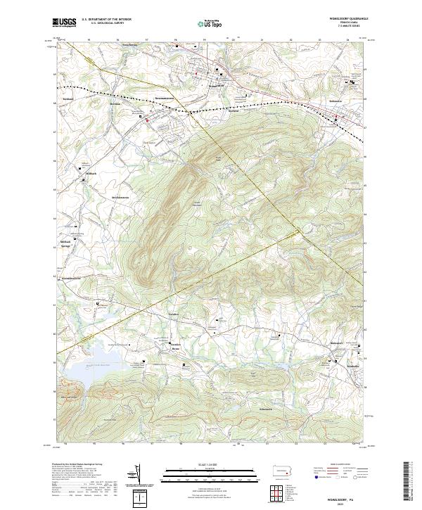 2023 Womelsdorf2023 Print · USGSIn the Pennsylvania Dutch countryside during the 2020s, this area maintains its deep sectarian roots between Womelsdorf and Schoeneck. Genealogists can trace family heritage through numerous sites like the Millbach Mennonite Cem, Flickingers Church Cem, and the Conrad Weiser Homestead and Memorial Park.
 - 2023 Map of Hershey, 2023 Print
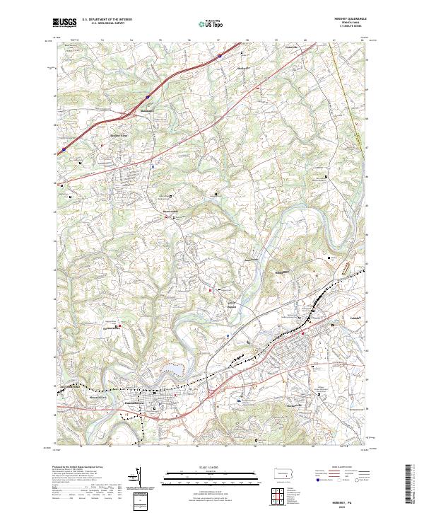 2023 Hershey2023 Print · USGSDauphin County’s chocolate-making heart and surrounding rural townships are shown in this modern survey. Genealogists and historians can trace the historic Union Canal or locate local burial grounds like Union Deposit Cem and Balsbaugh Cem.
 - 2023 Map of Tower City, 2023 Print
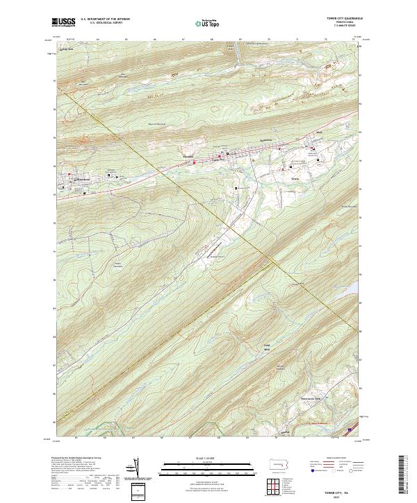 2023 Tower City2023 Print · USGSThe northern anthracite region comes to life in this detailed survey of the valley between Big Lick Mountain and Peters Mountain. Genealogists and local historians can trace the foundations of Tower City and Williamstown, locating local landmarks like the Sacred Heart Cem and the Gold Mine.
 - 2023 Map of Lykens, 2023 Print
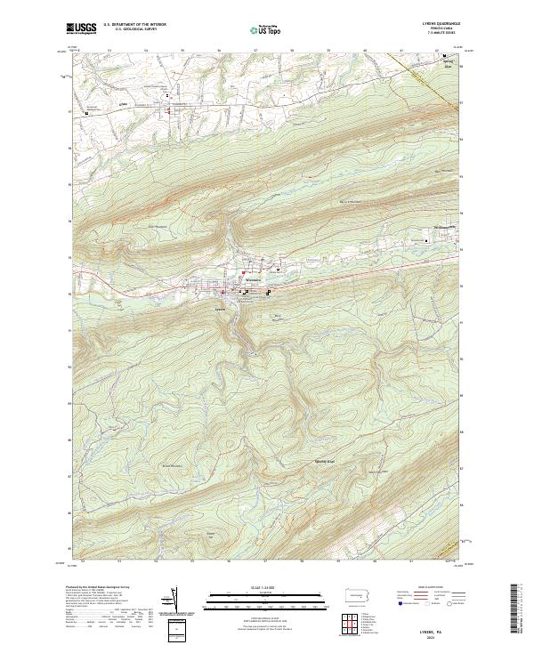 2023 Lykens2023 Print · USGSDauphin County communities like Lykens and Williamstown sit at the base of the anthracite ridges in this modern survey. Genealogists can locate several historic burial sites, including the Odd Fellows Cem and Patriotic Order Sons of America Cem.
 - 2023 Map of Strausstown, 2023 Print
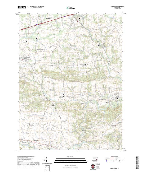 2023 Strausstown2023 Print · USGSBerks County’s rural heritage is well-preserved in this modern survey of the Tulpehocken valley and its surrounding farmland. Genealogists and historians can trace family roots at numerous local landmarks, including the Yoder Burial Ground, Kricks Mill, and the Union Canal.
 - 2023 Map of Manheim, 2023 Print
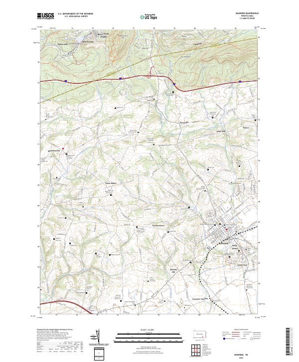 2023 Manheim2023 Print · USGSManheim and the surrounding Lancaster County countryside are shown here in the early twenty-first century, featuring a dense network of crossroads and family burial sites. Genealogists can locate family-named landmarks like the Abraham Gibbel Family Cem and Hanley-Longenecker Graveyard.
 - 2023 Map of Lebanon, 2023 Print
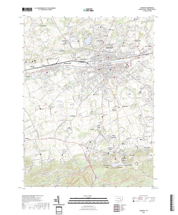 2023 Lebanon2023 Print · USGSIn the heart of Pennsylvania's Dutch Country, this map shows a landscape defined by its iron-making heritage and historic settlements. Genealogists can trace family lines through dozen of burial sites like the Moses Kreider Family Cem, while historians can locate the Cornwall Furnace and Burd Coleman Village.
 - 2023 Map of Lititz, 2023 Print
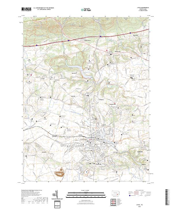 2023 Lititz2023 Print · USGSThe northern Lancaster County heartland appears here in the early twenty-first century, showcasing its unique Moravian and Mennonite roots. Genealogists can trace family names through dozens of burial sites like Steinmetz Cem or the Hess Family Cem.
 - 2023 Map of Fredericksburg, 2023 Print
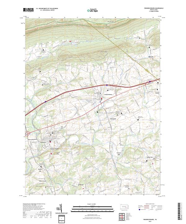 2023 Fredericksburg2023 Print · USGSLebanon County is depicted here in recent years, showing the enduring agricultural and religious landscape between Blue Mountain and Swatara Creek. Researchers can trace family sites at Grove Farm Cem or explore the route of the historic Union Canal.
End of results
Showing maps 1-16 of 16
Top cities of Lebanon County
- Lebanon historical maps
- Palmyra historical maps
- North Cornwall historical maps
- Annville historical maps
- East Hanover Township historical maps
- Myerstown historical maps
See more
Frequently asked questions
- What are the different types of historical maps available for Lebanon County?
- What is the oldest map of Lebanon County?
- Where can I purchase historical maps of Lebanon County for my home or office?
- Where can I download high-res historical maps of Lebanon County?
- Are there historical topographic maps available for Lebanon County?
- Is there historical aerial imagery available for Lebanon County?
- Where are historical maps of Lebanon County sourced from?