1970s Maps of Lebanon County, Pennsylvania
Explore 7 historic maps of Lebanon County from the 1970s. These maps offer a rare glimpse into what life looked like during the 1970s — showing old roads, neighborhoods, homes, and landmarks that have changed or disappeared over time.
Whether you're researching your family's past, planning a metal detecting trip, or studying how Lebanon County's landscape evolved across the 1970s, these high-resolution maps are a powerful tool for exploring the history of this region.
- Focus on a specific era: All maps on this page are from the 1970s, giving you a focused view of this time period.
- See what’s changed: Compare century-old streets, trails, and buildings to today's modern landscape using overlays and satellite layers.
- Research with precision: Use these maps for genealogy, historical research, land use analysis, or educational projects.
- View, download, or print: Maps are fully viewable online in high resolution, and can be downloaded or printed for your own records.
Start exploring Lebanon County's history through authentic maps from the 1970s. This is your window into the past.
Lebanon County, PA maps
(7)- 1977 Map of Fredericksburg, 1979 Print
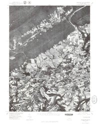
 1977 Fredericksburg1979 Print · USGSNorthern Lebanon County in the late seventies reveals a landscape of varied agricultural patterns and traditional settlements. Researchers can trace the development of Jonestown and Fredericksburg or locate features along Swatara Creek.
 - 1977 Map of Palmyra, 1979 Print
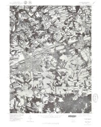 1977 Palmyra1979 Print · USGSCentral Pennsylvania's agricultural heartland is revealed in the late seventies, showing the growing footprint of Palmyra. Genealogists and historians can trace property lines and field patterns near Campbelltown or along the banks of Swatara Creek.
 - 1977 Map of Pine Grove, 1979 Print
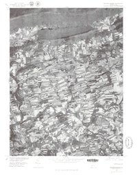
 1977 Pine Grove1979 Print · USGSPine Grove and the coal region foothills are seen from above in the late seventies as modern highways began to reshape the valley. Genealogists and local historians can trace the footprint of settlements like Suedberg and Ravine nestled between Second Mountain and Sharp Mountain.
 - 1977 Map of Hershey, 1979 Print
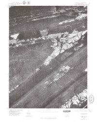
 1977 Hershey1979 Print · USGSDauphin County's industrial and residential heart is captured here in the late seventies, showing the rapid development around its famous chocolate center. Researchers can trace the winding course of Swatara Creek past the established streets of Hummelstown, Hockersville, and Union Deposit.
 - 1977 Map of Lebanon, 1979 Print
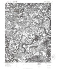
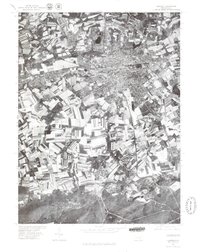 1977 Lebanon1979 Print · USGSLebanon County and its surrounding countryside are captured in this late 1970s aerial survey, showing the transition from urban centers to forested uplands. Trace the developed streets of Lebanon and Cleona or the rural character of Quentin and Cornwall.
 - 1977 Map of Tower City, 1979 Print
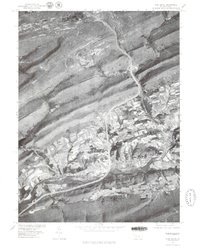
 1977 Tower City1979 Print · USGSThe western Schuylkill County coal region is seen here in the late seventies, showing how the dramatic mountain ridges shaped local life. Genealogists and local historians can trace the clear street grids and valley footprints of Tower City, Orwin, and Muir.
 - 1977 Map of Indiantown Gap, 1979 Print
 1977 Indiantown Gap1979 Print · USGSLebanon County's landscape in the late seventies reveals the intersection of mountain ridges and valley farming. Trace the early layout of Indiantown Gap and local crossroads like Harper Tavern and Lickdale.
End of results
Showing maps 1-7 of 7
Top cities of Lebanon County
- Lebanon historical maps
- Palmyra historical maps
- North Cornwall historical maps
- Annville historical maps
- East Hanover Township historical maps
- Myerstown historical maps
See more
Frequently asked questions
- What are the different types of historical maps available for Lebanon County?
- What is the oldest map of Lebanon County?
- Where can I purchase historical maps of Lebanon County for my home or office?
- Where can I download high-res historical maps of Lebanon County?
- Are there historical topographic maps available for Lebanon County?
- Is there historical aerial imagery available for Lebanon County?
- Where are historical maps of Lebanon County sourced from?