Old Maps of Buck Township, Pennsylvania for Academic Research
Study the evolution of Buck Township with 36 high-resolution historic maps. Whether you're teaching, researching, or modeling changes in land use, these maps provide essential visual documentation of urban, environmental, and geographic change.
- Analyze long-term change: Track patterns in development, transportation, and natural features.
- Ideal for environmental or urban studies: Support academic projects with primary historical map data.
- Use in the classroom or lab: Educators and researchers rely on these maps to bring historical context to life.
These maps are a powerful tool for teaching, research, and visualizing how Buck Township has changed over the decades.
Buck Township, PA maps
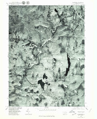
(36)- 1922 Map of Stoddartsville, 1958 Print
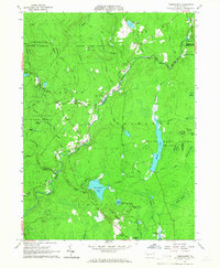
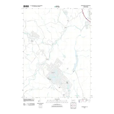
 1922 Stoddartsville1958 Print · USGSThe Pennsylvania Poconos at the turn of the century show a landscape of high timber ridges and early mountain resorts. Genealogists and hikers can trace the original paths to Stoddartsville, identify the old Fayette School, or follow the Wilkes-Barre and Eastern rail line.2 unique versions available
 - 1924 Map of Stoddartsville
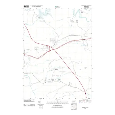
 1924 Stoddartsville1924 Print · USGSUpper Carbon and Monroe counties are shown in the early twenties as a landscape of timbered hills and headwater streams. Genealogists can locate old rural landmarks like Bradys Switch, the Leonardsville settlement, and the Locust Ridge School.5 unique versions available
 - 1943 Map of Scranton
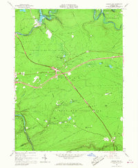
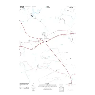
 1943 Scranton1943 Print · USGSNortheastern Pennsylvania’s coal and rail corridor comes to life in the 1940s, showcasing the dense urban industrial centers of the Wyoming Valley. Genealogists can locate family landmarks like the Fayette School and Locust Ridge School or trace the early paths of the DL & W and Erie railroads.
 - 1943 Map of Stoddartsville
 1943 Stoddartsville1943 Print · USGSThe Pocono Plateau at the height of the Second World War shows a landscape defined by river valleys and developing recreation preserves. Genealogists and local historians can trace rural schoolhouses and small settlements like Stoddartsville, Albrightsville, and the Fishery Sch.
 - 1950 Map of Scranton, 1952 Print
 1950 Scranton1952 Print · USGSMid-century Northeast Pennsylvania and the Hudson Valley come alive in this survey of the tri-state region. Genealogists and historians can trace the dense rail networks of the Erie RR and DL&W RR between industrial hubs like Scranton and Wilkes-Barre.
 - 1953 Map of Scranton
 1953 Scranton1953 Print · USGSNortheastern Pennsylvania and the Catskills are shown in great detail during the early fifties, a time when rail lines and river valleys dictated the region's growth. Genealogists and historians can trace the industrial hearts of Scranton and Wilkes-Barre or locate remote landmarks like High Point and Lake Wallenpaupack.
 - 1959 Map of Scranton
 1959 Scranton1959 Print · USGSThe northern coalfields and the Hudson Valley meet in this mid-century survey of the Pennsylvania and New York borderlands. Genealogists and historians can trace the intricate rail networks of the Erie Railroad and the vast waters of Lake Wallenpaupack.2 unique versions available
 - 1962 Map of Scranton, 1977 Print
 1962 Scranton1977 Print · USGSThe industrial heart of eastern Pennsylvania and the New York Catskills are captured here in the early sixties. Genealogists and historians can trace the dense valley settlements from Scranton to Wilkes-Barre and the rail lines of the Erie Lackawanna Railroad.2 unique versions available
 - 1965 Map of Scranton
 1965 Scranton1965 Print · USGSThe tri-state highlands of Pennsylvania, New York, and New Jersey come alive in the mid-sixties as industry and recreation converge. Trace the intricate rail lines of the Erie Lackawanna RR or locate landmarks like the U S Military Academy.2 unique versions available
 - 1965 Map of Thornhurst, 1967 Print
 1965 Thornhurst1967 Print · USGSThe Lehigh River corridor near Thornhurst shows a landscape of public forests and wetlands in the mid-1960s. Researchers can locate burial grounds like Pine Grove Cem and explore named swales such as City of Rome Dark Swamp.6 unique versions available
 - 1965 Map of Pleasant View Summit, 1967 Print
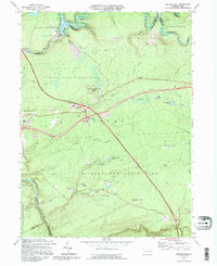
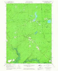 1965 Pleasant View Summit1967 Print · USGSThe Luzerne County highlands in the mid-sixties are shown here as a landscape of conservation and water management. You can trace the Francis E Walter Reservoir, the historic settlement at Stoddartsville, and an Old Railroad Grade.4 unique versions available
 - 1966 Map of Hickory Run, 1967 Print
 1966 Hickory Run1967 Print · USGSCarbon County is captured during its mid-century transition into a recreational hub as the new interstate highway system intersects old mountain roads. Trace the evolution of this landscape from the Central Railroad of New Jersey to the Boulder Field and Hickory Run State Park.3 unique versions available
 - 1976 Map of Pleasant View Summit, 1979 Print
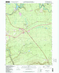
 1976 Pleasant View Summit1979 Print · USGSLuzerne County's forested heights and river valleys are captured in this mid-seventies aerial survey. Local historians can trace the early footprints of Stoddartsville and Shades Glen along the course of the Lehigh River.
 - 1976 Map of Hickory Run, 1979 Print
 1976 Hickory Run1979 Print · USGSCarbon County in the mid-seventies shows a landscape defined by its river corridors and the growing reach of highway infrastructure. Researchers can trace the layout of small settlements like Leonardsville and Saylorville along the banks of Hickory Run.
 - 1976 Map of Thornhurst, 1979 Print
 1976 Thornhurst1979 Print · USGSThe Lehigh Valley highlands are captured in the mid-seventies, showing the intersection of river geography and mountain development. Local historians can trace the settlement footprints of Thornhurst and Clifton or the shorelines of Bradys Lake and Arrowhead Lake.2 unique versions available
 - 1986 Map of Scranton
 1986 Scranton1986 Print · USGSNortheastern Pennsylvania in the mid-eighties shows an era of transition between its deep-rooted mining history and modern transit growth. Researchers can trace the industrial footprint of a Strip Mine, locate the Tobyhanna Army Depot, or find family sites near St Marys Cem and Wilkes College.2 unique versions available
 - 1992 Map of Pleasant View Summit, 1995 Print
 1992 Pleasant View Summit1995 Print · USGSThe high plateau of the Poconos in the 1990s reveals a landscape defined by state forests and historic watercourses. Genealogists and hikers can trace the Bear Creek Railroad Grade or locate old sites near Stoddartsville and Shades Glen.
 - 1992 Map of Hickory Run, 1995 Print
 1992 Hickory Run1995 Print · USGSThe Poconos region in the early nineties reveals a landscape where major transportation corridors like the Northeast Extension meet vast state-managed woodlands. Genealogists and researchers can trace the vicinity of Leonardsville or East Side and explore the rugged geology of Boulder Field.
 - 1997 Map of Thornhurst, 1998 Print
 1997 Thornhurst1998 Print · USGSThe Lehigh River valley and the Poconos plateau come into focus during the late nineties, showing a landscape shaped by conservation and seasonal recreation. Researchers can trace family sites at Clifton Cem or explore the wetlands of City of Rome Swamp and Bradys Lake.
 - 1997 Map of Hickory Run, 1998 Print
 1997 Hickory Run1998 Print · USGSCarbon County’s rugged Pocono plateau is defined here by protected lands and the Lehigh River corridor in the late nineties. Researchers can locate the sprawling Boulder Field, trace the old settlement at Leonardsville, or follow the Northeast Extension through Hickory Run State Park.
 - 1997 Map of Pleasant View Summit, 1999 Print
 1997 Pleasant View Summit1999 Print · USGSThe Pocono plateau near the turn of the millennium remained a landscape of dense forests and river confluences. Genealogists and hikers can trace old routes like Tannery Road, locate the Lookout Tower on Big Pine Hill, and explore the riverside site of Stoddartsville.
 - 2010 Map of Pleasant View Summit, 2010 Print
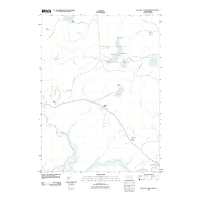 2010 Pleasant View Summit2010 Print · USGSCovers Buck Township, including Thornhurst Township, Kidder Township, and other nearby areas
 - 2010 Map of Thornhurst, 2010 Print
 2010 Thornhurst2010 Print · USGSCovers Buck Township, including Clifton Township, Thornhurst Township, and other nearby areas
 - 2010 Map of Hickory Run, 2010 Print
 2010 Hickory Run2010 Print · USGSCovers Buck Township, including Kidder Township, Hickory Run, and other nearby areas
 - 2013 Map of Hickory Run, 2013 Print
 2013 Hickory Run2013 Print · USGSCovers Buck Township, including Kidder Township, Hickory Run, and other nearby areas
Showing maps 1-25 of 36
Top cities near Buck Township
- Scranton historical maps
- Wilkes-Barre historical maps
- Plains Township historical maps
- Old Forge historical maps
- Pittston historical maps
- Kingston Township historical maps
See more
Top neighborhoods of Buck Township
Frequently asked questions
- What are the different types of historical maps available for Buck Township?
- What is the oldest map of Buck Township?
- Where can I purchase historical maps of Buck Township for my home or office?
- Where can I download high-res historical maps of Buck Township?
- Are there historical topographic maps available for Buck Township?
- Is there historical aerial imagery available for Buck Township?
- Where are historical maps of Buck Township sourced from?