1890s Maps of Huntington Township, Pennsylvania
Explore 2 historic maps of Huntington Township from the 1890s. These maps offer a rare glimpse into what life looked like during the 1890s — showing old roads, neighborhoods, homes, and landmarks that have changed or disappeared over time.
Whether you're researching your family's past, planning a metal detecting trip, or studying how Huntington Township's landscape evolved across the 1890s, these high-resolution maps are a powerful tool for exploring the history of this region.
- Focus on a specific era: All maps on this page are from the 1890s, giving you a focused view of this time period.
- See what’s changed: Compare century-old streets, trails, and buildings to today's modern landscape using overlays and satellite layers.
- Research with precision: Use these maps for genealogy, historical research, land use analysis, or educational projects.
- View, download, or print: Maps are fully viewable online in high resolution, and can be downloaded or printed for your own records.
Start exploring Huntington Township's history through authentic maps from the 1890s. This is your window into the past.
Huntington Township, PA maps
(2)- 1894 Map of Shickshinny
 1894 Shickshinny1894 Print · USGSLuzerne County at the height of the coal and canal era reveals a landscape shaped by river transport and mountain ridges. Trace the remnants of the Pennsylvania Canal and locate long-standing river crossings like Hicks Ferry and Beach Haven Ferry.6 unique versions available
 - 1894 Map of Bloomsburg
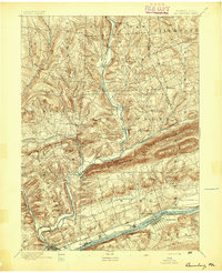 1894 Bloomsburg1894 Print · USGSThe Sesquehanna River valley in the late nineteenth century shows a landscape shaped by competing rail and water transport. Genealogists can trace family roots in river towns like Mifflinville or follow the mills and stations along Fishing Creek and the Sullivan RR.6 unique versions available
End of results
Showing maps 1-2 of 2
Top cities near Huntington Township
- Bloomsburg historical maps
- Nanticoke historical maps
- Berwick historical maps
- Dallas Township historical maps
- Lehman Township historical maps
- Harveys Lake historical maps
See more
Top neighborhoods of Huntington Township
- Cambra historical maps
- Southdale historical maps
- Town Hill historical maps
- Harveyville historical maps
- Huntington Mills historical maps
- Register historical maps
Frequently asked questions
- What are the different types of historical maps available for Huntington Township?
- What is the oldest map of Huntington Township?
- Where can I purchase historical maps of Huntington Township for my home or office?
- Where can I download high-res historical maps of Huntington Township?
- Are there historical topographic maps available for Huntington Township?
- Is there historical aerial imagery available for Huntington Township?
- Where are historical maps of Huntington Township sourced from?