1920s Maps of Lycoming County, Pennsylvania
Explore 10 historic maps of Lycoming County from the 1920s. These maps offer a rare glimpse into what life looked like during the 1920s — showing old roads, neighborhoods, homes, and landmarks that have changed or disappeared over time.
Whether you're researching your family's past, planning a metal detecting trip, or studying how Lycoming County's landscape evolved across the 1920s, these high-resolution maps are a powerful tool for exploring the history of this region.
- Focus on a specific era: All maps on this page are from the 1920s, giving you a focused view of this time period.
- See what’s changed: Compare century-old streets, trails, and buildings to today's modern landscape using overlays and satellite layers.
- Research with precision: Use these maps for genealogy, historical research, land use analysis, or educational projects.
- View, download, or print: Maps are fully viewable online in high resolution, and can be downloaded or printed for your own records.
Start exploring Lycoming County's history through authentic maps from the 1920s. This is your window into the past.
Lycoming County, PA maps
(10)- 1921 Map of Williamsport
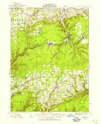
 1921 Williamsport1921 Print · USGSWilliamsport and the West Branch Susquehanna valley are captured here in the early 1920s, showing a landscape defined by rail corridors and steep mountain ridges. Genealogists can locate family-named schools and social landmarks like the Morgan Valley School, Nippono Park, and Shakespeare Club.
 - 1921 Map of Trout Run, 1957 Print
 1921 Trout Run1957 Print · USGSThe Lycoming Creek valley in the 1920s served as a vital transit and industrial corridor north of Williamsport. Genealogists and local historians can trace family ties through dozens of named rural schools, including Beech Grove School and Chestnut Grove School, or locate early industry at Balls Mills.3 unique versions available
 - 1921 Map of Lock Haven, 1958 Print
 1921 Lock Haven1958 Print · USGSLock Haven and the Susquehanna River West Branch are captured in the early twenties, showing a landscape defined by industry and mountain ridges. Researchers can trace historic schools and family hamlets from Woolrich to Logan Mills, or locate the State Normal School and Great Island.2 unique versions available
 - 1923 Map of Lock Haven
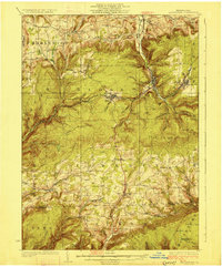
 1923 Lock Haven1923 Print · USGSThe West Branch Susquehanna River corridor in the early twenties reveals a landscape of industrial river towns and isolated mountain valleys. Genealogists can locate family landmarks like the Swissdale School, Liberty Church, and the grounds of the State Normal School.7 unique versions available
 - 1923 Map of Trout Run
 1923 Trout Run1923 Print · USGSLycoming County in the early 1920s shows a mountain landscape defined by small valley settlements and a dense network of country schools. You can trace family roots at Anthony Church or locate vanished industrial sites like the Nail Factory and Balls Mills.4 unique versions available
 - 1923 Map of Williamsport
 1923 Williamsport1923 Print · USGSWilliamsport and the Susquehanna riverfront are captured here in the early twenties, showing a region defined by industrial rail lines and steep ridges. You can trace the path of the Pennsylvania Canal (Abandoned) or locate rural landmarks like Nippono Park and the Captain Greene Monument.6 unique versions available
 - 1924 Map of Milton
 1924 Milton1924 Print · USGSNorthumberland and Lycoming counties thrived along the river during the 1920s, dominated by a dense network of mountain ridges and rail corridors. Genealogists can locate dozens of rural landmarks, from the Old Furnace to the Stone Church and Pioneer School.4 unique versions available
 - 1925 Map of Blossburg, 1958 Print
 1925 Blossburg1958 Print · USGSTioga County’s coal and timber country is captured here during the 1920s, when the Tioga River and Erie R R drove the local economy. Researchers can locate dozens of country schoolhouses, rural churches like Burt Church, and early industrial sites such as Blacks Mill.2 unique versions available
 - 1927 Map of Eagles Mere
 1927 Eagles Mere1927 Print · USGSSullivan and Lycoming Counties were a network of mountain resorts and valley hamlets in the late twenties. Researchers can trace the grounds of the Ogdonia Clubhouse, locate the Mawrglen Post Office, and find remote rural schools like Glidewell Sch.
 - 1927 Map of Blossburg
 1927 Blossburg1927 Print · USGSTioga County's coal country and rural townships are captured here in the mid-1920s, showing the height of the mountain rail and mining era. Genealogists can locate family-named sites like Blacks Mill, Hart Church, and vanished schoolhouses such as Culver School.4 unique versions available
End of results
Showing maps 1-10 of 10
Top cities of Lycoming County
- Williamsport historical maps
- South Williamsport historical maps
- Montoursville historical maps
- Jersey Shore historical maps
- Montgomery historical maps
- Duboistown historical maps
See more
Frequently asked questions
- What are the different types of historical maps available for Lycoming County?
- What is the oldest map of Lycoming County?
- Where can I purchase historical maps of Lycoming County for my home or office?
- Where can I download high-res historical maps of Lycoming County?
- Are there historical topographic maps available for Lycoming County?
- Is there historical aerial imagery available for Lycoming County?
- Where are historical maps of Lycoming County sourced from?