1920s Maps of Wolf Township, Pennsylvania
Explore 2 historic maps of Wolf Township from the 1920s. These maps offer a rare glimpse into what life looked like during the 1920s — showing old roads, neighborhoods, homes, and landmarks that have changed or disappeared over time.
Whether you're researching your family's past, planning a metal detecting trip, or studying how Wolf Township's landscape evolved across the 1920s, these high-resolution maps are a powerful tool for exploring the history of this region.
- Focus on a specific era: All maps on this page are from the 1920s, giving you a focused view of this time period.
- See what’s changed: Compare century-old streets, trails, and buildings to today's modern landscape using overlays and satellite layers.
- Research with precision: Use these maps for genealogy, historical research, land use analysis, or educational projects.
- View, download, or print: Maps are fully viewable online in high resolution, and can be downloaded or printed for your own records.
Start exploring Wolf Township's history through authentic maps from the 1920s. This is your window into the past.
Wolf Township, PA maps
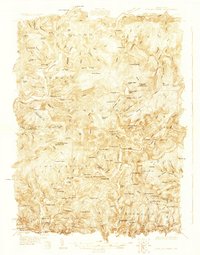
(2)- 1924 Map of Milton
 1924 Milton1924 Print · USGSNorthumberland and Lycoming counties thrived along the river during the 1920s, dominated by a dense network of mountain ridges and rail corridors. Genealogists can locate dozens of rural landmarks, from the Old Furnace to the Stone Church and Pioneer School.4 unique versions available
 - 1927 Map of Eagles Mere
 1927 Eagles Mere1927 Print · USGSSullivan and Lycoming Counties were a network of mountain resorts and valley hamlets in the late twenties. Researchers can trace the grounds of the Ogdonia Clubhouse, locate the Mawrglen Post Office, and find remote rural schools like Glidewell Sch.
End of results
Showing maps 1-2 of 2
Top cities near Wolf Township
- Montoursville historical maps
- White Deer Township historical maps
- Greenwood Township historical maps
- Montgomery historical maps
- Moreland Township historical maps
- Millville historical maps
See more
Top neighborhoods of Wolf Township
Frequently asked questions
- What are the different types of historical maps available for Wolf Township?
- What is the oldest map of Wolf Township?
- Where can I purchase historical maps of Wolf Township for my home or office?
- Where can I download high-res historical maps of Wolf Township?
- Are there historical topographic maps available for Wolf Township?
- Is there historical aerial imagery available for Wolf Township?
- Where are historical maps of Wolf Township sourced from?