1950s Maps of Wolf Township, Pennsylvania
Explore 5 historic maps of Wolf Township from the 1950s. These maps offer a rare glimpse into what life looked like during the 1950s — showing old roads, neighborhoods, homes, and landmarks that have changed or disappeared over time.
Whether you're researching your family's past, planning a metal detecting trip, or studying how Wolf Township's landscape evolved across the 1950s, these high-resolution maps are a powerful tool for exploring the history of this region.
- Focus on a specific era: All maps on this page are from the 1950s, giving you a focused view of this time period.
- See what’s changed: Compare century-old streets, trails, and buildings to today's modern landscape using overlays and satellite layers.
- Research with precision: Use these maps for genealogy, historical research, land use analysis, or educational projects.
- View, download, or print: Maps are fully viewable online in high resolution, and can be downloaded or printed for your own records.
Start exploring Wolf Township's history through authentic maps from the 1950s. This is your window into the past.
Wolf Township, PA maps
(5)- 1953 Map of Hughesville, 1956 Print
 1953 Hughesville1956 Print · USGSThe rural heart of Lycoming and Columbia Counties is captured here in the early fifties, showing a landscape defined by small townships and creek-side settlements. Researchers can locate vanished rural landmarks like Frenchtown Sch, Hendrickson Ch, and the streets of Washingtonville or Jerseytown.3 unique versions available
 - 1953 Map of Warrensville, 1956 Print
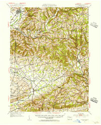
 1953 Warrensville1956 Print · USGSThe mountains and valleys of Lycoming County are shown in detail during the early fifties, from the railroad corridor at Bodines to the farms of Montoursville. Genealogists can locate family-named landmarks like Quaker Hill, the Church of the Assumption, and small hamlets such as Barbours or Hoppestown.2 unique versions available
 - 1953 Map of Eagles Mere, 1956 Print
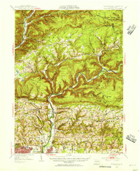
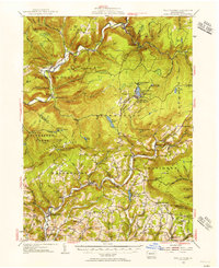 1953 Eagles Mere1956 Print · USGSThe Sullivan County highlands appear in the early 1950s as a landscape of mountain retreats and valley hamlets. Researchers can trace rural landmarks from Picture Rocks to Eagles Mere Park, including Rock Run Ch and the Mawrglen PO.3 unique versions available
 - 1953 Map of Milton, 1956 Print
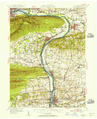 1953 Milton1956 Print · USGSThe Susquehanna Valley thrives during the early fifties, defined by its river-town industries and coal-hauling rail lines. Genealogists can trace family names through country landmarks like Stone Church, Old Furnace, and the U S Military Reservation.2 unique versions available
 - 1954 Map of Williamsport
 1954 Williamsport1954 Print · USGSNorth-central Pennsylvania in the mid-fifties is defined by the winding West Branch Susquehanna River and its industrial valley. Local historians can trace the massive Susquehanna Ordnance Depot and the extensive rail networks of the Pennsylvania Railroad.
End of results
Showing maps 1-5 of 5
Top cities near Wolf Township
- Montoursville historical maps
- White Deer Township historical maps
- Greenwood Township historical maps
- Montgomery historical maps
- Moreland Township historical maps
- Millville historical maps
See more
Top neighborhoods of Wolf Township
Frequently asked questions
- What are the different types of historical maps available for Wolf Township?
- What is the oldest map of Wolf Township?
- Where can I purchase historical maps of Wolf Township for my home or office?
- Where can I download high-res historical maps of Wolf Township?
- Are there historical topographic maps available for Wolf Township?
- Is there historical aerial imagery available for Wolf Township?
- Where are historical maps of Wolf Township sourced from?