1940s Maps of McKean County, Pennsylvania
Explore 13 historic maps of McKean County from the 1940s. These maps offer a rare glimpse into what life looked like during the 1940s — showing old roads, neighborhoods, homes, and landmarks that have changed or disappeared over time.
Whether you're researching your family's past, planning a metal detecting trip, or studying how McKean County's landscape evolved across the 1940s, these high-resolution maps are a powerful tool for exploring the history of this region.
- Focus on a specific era: All maps on this page are from the 1940s, giving you a focused view of this time period.
- See what’s changed: Compare century-old streets, trails, and buildings to today's modern landscape using overlays and satellite layers.
- Research with precision: Use these maps for genealogy, historical research, land use analysis, or educational projects.
- View, download, or print: Maps are fully viewable online in high resolution, and can be downloaded or printed for your own records.
Start exploring McKean County's history through authentic maps from the 1940s. This is your window into the past.
McKean County, PA maps
(13)- 1940 Map of Mt. Jewett
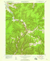
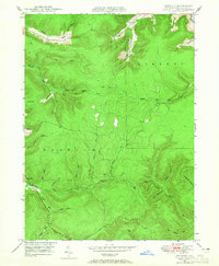
 1940 Mt. Jewett1940 Print · USGSNorthern Pennsylvania’s timber and rail country is captured here during the mid-1930s, showing a landscape defined by industrial development. Researchers can locate vanished rural infrastructure like the Stenstrom Sch, the CCC Camp, and specific rail stops at Dahoga and Instanter.3 unique versions available
 - 1941 Map of Kinzua
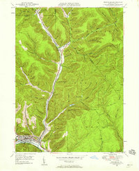
 1941 Kinzua1941 Print · USGSThe Allegheny River valley and the Cornplanter Indian Reservation are shown here in the years before mid-century dam projects forever changed the landscape. Researchers can trace the river-level Pennsylvania Railroad, the Kinzua Coal Mine, and now-submerged settlements like Kinzua and Corydon.3 unique versions available
 - 1941 Map of Bradford, 1958 Print
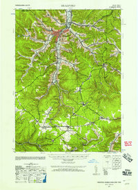 1941 Bradford1958 Print · USGSMcKean County's industrial landscape was at its peak during the early 1940s, marked by a dense network of mountain railroads and small oil-country settlements. Genealogists can trace family roots through numerous rural landmarks like Songbird Sch, Irishtown, and Davis Gifford PO.2 unique versions available
 - 1944 Map of Bradford
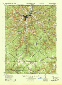 1944 Bradford1944 Print · USGSMcKean County and the New York borderlands are shown here during the mid-1940s, a period defined by heavy rail traffic and mountain settlements. You can trace old property lines and rural schoolhouses like Bolivar Run Sch, or find the Gifford PO and Big Shanty Sta along the timber and oil valleys.
 - 1948 Map of Crosby, 1952 Print
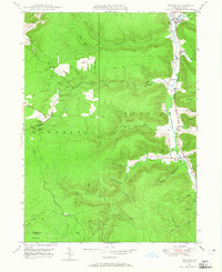
 1948 Crosby1952 Print · USGSPost-war McKean and Cameron counties appear here as a landscape of mountain rail lines and valley settlements. Trace the Pennsylvania Railroad through Hamlin Sta, locate the Sweets Sch, or find family names near Clermont Cem.3 unique versions available
 - 1948 Map of Emporium, 1952 Print
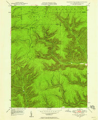
 1948 Emporium1952 Print · USGSThe northern Pennsylvania highlands come into focus in the late 1940s, showing a network of mountain settlements and headwater streams. You can trace family roots at Wharton Cem and St Marks Cem or locate old schoolhouse sites like Reesville Sch.3 unique versions available
 - 1948 Map of Keating Summit, 1958 Print
 1948 Keating Summit1958 Print · USGSThe high plateau of the McKean and Potter County border comes to life in this post-war survey, centered on the railroad pass at Keating Summit. Genealogists and local historians can trace the remote valley settlements of Liberty and Odin or locate family landmarks in Slabtown Hollow.3 unique versions available
 - 1948 Map of Emporium, 1958 Print
 1948 Emporium1958 Print · USGSEmporium and the Sinnemahoning valley are captured here just after the war, showing the railroad and highway networks through the Cameron County mountains. Genealogists can trace family names across Newton Cem, Sizerville, and Prospect Park.6 unique versions available
 - 1948 Map of Wildwood Fire Tower, 1958 Print
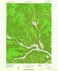
 1948 Wildwood Fire Tower1958 Print · USGSThe Pennsylvania high country of Elk and McKean counties comes into focus in the years just after the war, showing a landscape of deep hollows and forest runs. Genealogists and hikers can trace the remote reaches of Wellendorf Station, Devils Hole, and Boy Scout Hollow.5 unique versions available
 - 1948 Map of Rich Valley, 1962 Print
 1948 Rich Valley1962 Print · USGSCameron County in the late 1940s is defined by its deep valleys and the winding path of the Sinnemahoning. Genealogists and historians can trace old homesteads and landmarks like Lockwood, the Swesey Sch, and the North Creek Chapel along the rail and river corridors.4 unique versions available
 - 1948 Map of Norwich, 1965 Print
 1948 Norwich1965 Print · USGSThe hills of McKean County are captured here in the late 1940s, showing a landscape shaped by timber, early industry, and deep hollows. Researchers can locate the settlement of Norwich and trace the paths of Railroad Run, a Pipe Line, and family-named landmarks like Evans Hill.4 unique versions available
 - 1948 Map of Crosby, 1965 Print
 1948 Crosby1965 Print · USGSMcKean County at the end of the 1940s reveals a rugged landscape of narrow valley settlements and high-altitude pipe lines. Local historians can trace the rail sidings at Hamlin Sta and search for family roots at Norwich Cem or the isolated village of Betula.3 unique versions available
 - 1949 Map of Kinzua, 1954 Print
 1949 Kinzua1954 Print · USGSThe Allegheny River valley remains the heart of this region in the late 1940s, just before major changes altered the landscape. Researchers can trace riverside life in Kinzua and Corydon or locate the historic Cornplanter Indian Reservation.4 unique versions available
End of results
Showing maps 1-13 of 13
Top cities of McKean County
- Bradford historical maps
- Kane historical maps
- Lafayette Township historical maps
- Port Allegany historical maps
- Liberty Township historical maps
- Smethport historical maps
See more
Frequently asked questions
- What are the different types of historical maps available for McKean County?
- What is the oldest map of McKean County?
- Where can I purchase historical maps of McKean County for my home or office?
- Where can I download high-res historical maps of McKean County?
- Are there historical topographic maps available for McKean County?
- Is there historical aerial imagery available for McKean County?
- Where are historical maps of McKean County sourced from?