1960s Maps of Eldred Township, Pennsylvania
Explore 1 historic maps of Eldred Township from the 1960s. These maps offer a rare glimpse into what life looked like during the 1960s — showing old roads, neighborhoods, homes, and landmarks that have changed or disappeared over time.
Whether you're researching your family's past, planning a metal detecting trip, or studying how Eldred Township's landscape evolved across the 1960s, these high-resolution maps are a powerful tool for exploring the history of this region.
- Focus on a specific era: All maps on this page are from the 1960s, giving you a focused view of this time period.
- See what’s changed: Compare century-old streets, trails, and buildings to today's modern landscape using overlays and satellite layers.
- Research with precision: Use these maps for genealogy, historical research, land use analysis, or educational projects.
- View, download, or print: Maps are fully viewable online in high resolution, and can be downloaded or printed for your own records.
Start exploring Eldred Township's history through authentic maps from the 1960s. This is your window into the past.
Eldred Township, PA maps
(1)- 1969 Map of Eldred, 1972 Print
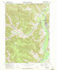 1969 Eldred1972 Print · USGSMcKean County and the New York border region are captured here in the late sixties, showing the active Bradford Oil Field and the Allegheny River corridor. Researchers can trace family sites at Lamphier Cem, find the Township Sch, or explore the rail network through Larabee and West Eldred.3 unique versions available
End of results
Showing maps 1-1 of 1
Top cities near Eldred Township
- Olean historical maps
- Bradford historical maps
- Allegany historical maps
- Portville historical maps
- Lafayette Township historical maps
- Port Allegany historical maps
See more
Top neighborhoods of Eldred Township
- Bullis Mills historical maps
- Indian Crossing historical maps
- Larabee historical maps
- West Eldred historical maps
- Wigwam historical maps
- Haymaker historical maps
Frequently asked questions
- What are the different types of historical maps available for Eldred Township?
- What is the oldest map of Eldred Township?
- Where can I purchase historical maps of Eldred Township for my home or office?
- Where can I download high-res historical maps of Eldred Township?
- Are there historical topographic maps available for Eldred Township?
- Is there historical aerial imagery available for Eldred Township?
- Where are historical maps of Eldred Township sourced from?