1920s Maps of Rew, Foster Township
Explore 2 historic maps of Rew from the 1920s. These maps offer a rare glimpse into what life looked like during the 1920s — showing old roads, neighborhoods, homes, and landmarks that have changed or disappeared over time.
Whether you're researching your family's past, planning a metal detecting trip, or studying how Rew's landscape evolved across the 1920s, these high-resolution maps are a powerful tool for exploring the history of this region.
- Focus on a specific era: All maps on this page are from the 1920s, giving you a focused view of this time period.
- See what’s changed: Compare century-old streets, trails, and buildings to today's modern landscape using overlays and satellite layers.
- Research with precision: Use these maps for genealogy, historical research, land use analysis, or educational projects.
- View, download, or print: Maps are fully viewable online in high resolution, and can be downloaded or printed for your own records.
Start exploring Rew's history through authentic maps from the 1920s. This is your window into the past.
Rew, Foster Township maps
(2)- 1924 Map of Bradford
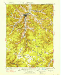 1924 Bradford1924 Print · USGSMcKean County's industrial heartland is captured here in the mid-1920s, showing a landscape defined by timber, chemicals, and heavy rail. Trace early infrastructure from the KINZUA VIADUCT to family-named landmarks like Corwins Corners and Bells Camp.2 unique versions available
 - 1926 Map of Bradford
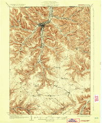 1926 Bradford1926 Print · USGSNorthwestern Pennsylvania's oil and timber country comes alive in the mid-twenties, centered on the bustling industrial valley of Bradford. Researchers can trace the path of the Bradford Electric Ry, find local homesteads near Custer City, or locate the famed Kinzua Viaduct.4 unique versions available
End of results
Showing maps 1-2 of 2
Top cities near Rew
- Olean historical maps
- Bradford historical maps
- Allegany historical maps
- Portville historical maps
- Lafayette Township historical maps
- Great Valley historical maps
See more
Frequently asked questions
- What are the different types of historical maps available for Rew?
- What is the oldest map of Rew?
- Where can I purchase historical maps of Rew for my home or office?
- Where can I download high-res historical maps of Rew?
- Are there historical topographic maps available for Rew?
- Is there historical aerial imagery available for Rew?
- Where are historical maps of Rew sourced from?