
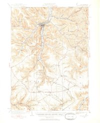
1924 Map of Bradford
USGS Topo · Published 1924About this map
Industrial activity defines this corner of McKean County, where the valley of Tuna Creek meets a dense network of timber and chemical processing sites. In the mid-1920s, the Nusbaum Chemical Plant and Hazelton Mills highlight the region's reliance on local natural resources, while the massive Kinzua Viaduct stands as a landmark of railroad engineering in the south. The settlement of Bradford serves as the primary hub, surrounded by smaller communities such as Derrick City, Lewis Run, and Custer City.
Find a feature on this map
123 named features on this map. Tap any name to fly to it.
Don’t see what you’re looking for? This feature index may not catch every label — zoom into the map to look around manually.
Map Details
Editions of this 1924 Bradford Map
2 editions found
Other maps of this area

1898 · Olean
USGS Topo · 1:62,500

1900 · Salamanca
USGS Topo · 1:62,500

1922 · Randolph
USGS Topo · 1:62,500

1923 · Randolph
USGS Topo · 1:62,500

1926 · Bradford
USGS Topo · 1:62,500

1933 · Smethport
USGS Topo · 1:62,500

1934 · Kane
USGS Topo · 1:48,000

1935 · Mt. Jewett
USGS Topo · 1:48,000

1936 · Kinzua
USGS Topo · 1:48,000

1937 · Smethport
USGS Topo · 1:62,500