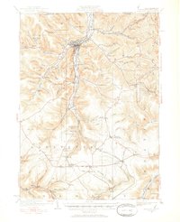
1924 Map of Bradford
USGS Topo · Published 1952About this map
Bradford anchors this 1924 survey of McKean County, revealing a landscape defined by the intersection of early industrial chemistry and a dense rail network. The Nusbaum Chemical Plant stands near Custer City, while the famous Kinzua Viaduct spans the southern valley, carrying the Pittsburgh Shawmut and Northern RR. The geography is characterized by narrow runs and hollows like Hedgehog Hollow and Garlock Hollow, which constrained the growth of settlements like Sawyer City and Derrick City. Local history is preserved through numerous rural schoolhouses, including the Songbird School and Bennett Brook School, alongside specific post offices such as Gifford P.O. and Simpson Cyclone P.O.. This era captures the region at its industrial peak, where railroads including the Erie RR and Pennsylvania RR served as the primary arteries for the timber and chemical trades.
Find a feature on this map
131 named features on this map. Tap any name to fly to it.
Don’t see what you’re looking for? This feature index may not catch every label — zoom into the map to look around manually.
Map Details
Editions of this 1924 Bradford Map
2 editions found
Other maps of this area

1898 · Olean
USGS Topo · 1:62,500

1900 · Salamanca
USGS Topo · 1:62,500

1922 · Randolph
USGS Topo · 1:62,500

1923 · Randolph
USGS Topo · 1:62,500

1924 · Bradford
USGS Topo · 1:62,500

1926 · Bradford
USGS Topo · 1:62,500

1933 · Smethport
USGS Topo · 1:62,500

1934 · Kane
USGS Topo · 1:48,000

1935 · Mt. Jewett
USGS Topo · 1:48,000

1936 · Kinzua
USGS Topo · 1:48,000