1900s (20th Century) Maps of Liberty Township, Pennsylvania
Explore 11 historic maps of Liberty Township from the 1900s (20th Century). These maps offer a rare glimpse into what life looked like during the 1900s — showing old roads, neighborhoods, homes, and landmarks that have changed or disappeared over time.
Whether you're researching your family's past, planning a metal detecting trip, or studying how Liberty Township's landscape evolved across the 1900s, these high-resolution maps are a powerful tool for exploring the history of this region.
- Focus on a specific era: All maps on this page are from the 1900s, giving you a focused view of this time period.
- See what’s changed: Compare century-old streets, trails, and buildings to today's modern landscape using overlays and satellite layers.
- Research with precision: Use these maps for genealogy, historical research, land use analysis, or educational projects.
- View, download, or print: Maps are fully viewable online in high resolution, and can be downloaded or printed for your own records.
Start exploring Liberty Township's history through authentic maps from the 1900s. This is your window into the past.
Liberty Township, PA maps
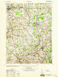
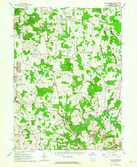
(11)- 1913 Map of Mercer
 1913 Mercer1913 Print · USGSMercer and Grove City anchor this early twentieth-century landscape during a period of coal mining and railway expansion. Genealogists can trace family roots through numerous local schools like Bottle Hill School and rural settlements such as Pardoe and Amsterdam.6 unique versions available
 - 1939 Map of Mercer, 1959 Print
 1939 Mercer1959 Print · USGSWestern Pennsylvania during the late 1930s shows a landscape of thriving coal mining, manufacturing, and education. Researchers can trace the rail-and-river economy through the Pennsylvania railroad lines, the Number Five Mine, and the local Normal School.
 - 1943 Map of Mercer
 1943 Mercer1943 Print · USGSMid-century Mercer County and northern Lawrence County are captured here as vital hubs of Pennsylvania rail and milling. Researchers can trace the legacy of local industry at Kimbles Mills, the Number Five Mine, and the Slippery Rock State Normal School.
 - 1950 Map of Cleveland
 1950 Cleveland1950 Print · USGSCovers Liberty Township, including Cleveland, Akron, and other nearby areas
 - 1956 Map of Cleveland, 1967 Print
 1956 Cleveland1967 Print · USGSNortheast Ohio and Western Pennsylvania are shown at their industrial height during the mid-fifties, from the steel mills to the lakeshore. Researchers can trace the massive Ravenna Arsenal, the Ohio Turnpike, and vanished rail sidings of the B & O RR.3 unique versions available
 - 1961 Map of Grove City, 1963 Print
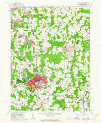 1961 Grove City1963 Print · USGSGrove City and Harrisville are shown in the early 1960s as industrial rail centers and college towns. Researchers can trace the Bessemer and Lake Erie line past Grove City College, Ebenezer Church, and local strip mines.4 unique versions available
 - 1961 Map of Mercer, 1964 Print
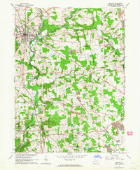 1961 Mercer1964 Print · USGSIn the early 1960s, the Mercer area of Pennsylvania was a hub of rail transport and heavy industry. Genealogists and historians can trace family roots through Findley Cem, local landmarks like Nazareth Ch, and industry sites like the Number Five Mine.4 unique versions available
 - 1961 Map of Slippery Rock, 1964 Print
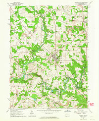 1961 Slippery Rock1964 Print · USGSSlippery Rock and its collegiate surroundings appear in the early sixties, caught between their industrial heritage and educational growth. Researchers can trace family-named landmarks like Moores Corners and Keisters, or locate early industrial sites such as Doughertys Mills and numerous oil wells.4 unique versions available
 - 1961 Map of Harlansburg, 1964 Print
 1961 Harlansburg1964 Print · USGSLawrence County at the dawn of the 1960s reveals a rural landscape defined by active mining and quiet river camps. Genealogists and local historians can trace family-named roads and sites like Harlansburg, Elliotts Mills, and the Jackson School.3 unique versions available
 - 1962 Map of Cleveland
 1962 Cleveland1962 Print · USGSNortheast Ohio and the Pennsylvania borderlands appear here during the industrial peak of the early sixties. Genealogists and historians can trace the expansive rail lines of the Nickel Plate Road and the growth of suburbs from Parma to Lyndhurst.
 - 1986 Map of Youngstown, 1988 Print
 1986 Youngstown1988 Print · USGSThe industrial corridor of the Mahoning Valley and the collegiate towns of Western Pennsylvania are captured here in the mid-eighties. Researchers can trace the rail lines of the Conrail network or locate historical sites like Churchill and Crown Hill Cem.2 unique versions available
End of results
Showing maps 1-11 of 11
Top cities near Liberty Township
- New Castle historical maps
- Grove City historical maps
- Slippery Rock historical maps
- Muddy Creek historical maps
- Mercer historical maps
- Prospect historical maps
See more
Top neighborhoods of Liberty Township
- Carmona historical maps
- Courtneys Mills historical maps
- Heath historical maps
- North Liberty historical maps
- Valcourt historical maps
- McCoys Corners historical maps
See more
Frequently asked questions
- What are the different types of historical maps available for Liberty Township?
- What is the oldest map of Liberty Township?
- Where can I purchase historical maps of Liberty Township for my home or office?
- Where can I download high-res historical maps of Liberty Township?
- Are there historical topographic maps available for Liberty Township?
- Is there historical aerial imagery available for Liberty Township?
- Where are historical maps of Liberty Township sourced from?