1920s Maps of Mifflin County, Pennsylvania
Explore 7 historic maps of Mifflin County from the 1920s. These maps offer a rare glimpse into what life looked like during the 1920s — showing old roads, neighborhoods, homes, and landmarks that have changed or disappeared over time.
Whether you're researching your family's past, planning a metal detecting trip, or studying how Mifflin County's landscape evolved across the 1920s, these high-resolution maps are a powerful tool for exploring the history of this region.
- Focus on a specific era: All maps on this page are from the 1920s, giving you a focused view of this time period.
- See what’s changed: Compare century-old streets, trails, and buildings to today's modern landscape using overlays and satellite layers.
- Research with precision: Use these maps for genealogy, historical research, land use analysis, or educational projects.
- View, download, or print: Maps are fully viewable online in high resolution, and can be downloaded or printed for your own records.
Start exploring Mifflin County's history through authentic maps from the 1920s. This is your window into the past.
Mifflin County, PA maps
(7)- 1922 Map of Mt Union
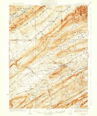
 1922 Mt Union1922 Print · USGSThe Juniata River valley in the early 1920s reveals a landscape shaped by the Pennsylvania RR and early motor routes like the Lincoln Highway. Genealogists can trace dozens of rural schoolhouses and vanished post offices, including Red Fork PO, Shirleysburg, and Lucy Furnace School.2 unique versions available
 - 1924 Map of Mt. Union
 1924 Mt. Union1924 Print · USGSMount Union and the central Juniata River valley are shown here in the mid-twenties as the rail-and-river economy flourished. Genealogists can locate dozens of named rural schools like Smoke School and old post offices such as Shade Valley P.O.4 unique versions available
 - 1924 Map of Centre Hall, 1958 Print
 1924 Centre Hall1958 Print · USGSCentral Pennsylvania's ridge-and-valley landscape is captured here in the 1920s, showing a world of limestone springs and mountain gaps. Genealogists can locate family homesteads near Old Fort, Tusseyville, and dozens of rural schoolhouses like Gentzel School.2 unique versions available
 - 1924 Map of Lewistown, 1958 Print
 1924 Lewistown1958 Print · USGSMifflin County settlements line the river and valley floor during the mid-1920s, showing the region's transition from agrarian mills to industrial rail hubs. Researchers can locate vanished rural landmarks such as Union Mills, Emma Chapel, and numerous family-named sites like Strodes Mills.2 unique versions available
 - 1925 Map of Mifflintown
 1925 Mifflintown1925 Print · USGSJuniata County in the mid-1920s is a landscape of river-oriented towns and remote mountain gaps. Genealogists and historians can trace family roots through numerous local landmarks like Peach Blossom School, Jericho Mills, and the village of Mifflintown.
 - 1927 Map of Lewisburg
 1927 Lewisburg1927 Print · USGSThe central Pennsylvania landscape in the 1920s is defined here by the winding Juniata River and the industrial hubs of Lewistown and Burnham. Local historians can trace old river crossings like Lafolds Ford or the many rural schoolhouses like Yoder School and Brice School.5 unique versions available
 - 1929 Map of Centre Hall
 1929 Centre Hall1929 Print · USGSCentral Pennsylvania's ridge-and-valley country is shown here in the late 1920s as a landscape of rural schools and water mills. Genealogists can trace family footprints at Old Fort, Penn Cave, and dozens of school sites like Gentzel School.4 unique versions available
End of results
Showing maps 1-7 of 7
Top cities of Mifflin County
- Lewistown historical maps
- Granville Township historical maps
- Decatur Township historical maps
- Burnham historical maps
- Menno Township historical maps
- Juniata Terrace historical maps
See more
Frequently asked questions
- What are the different types of historical maps available for Mifflin County?
- What is the oldest map of Mifflin County?
- Where can I purchase historical maps of Mifflin County for my home or office?
- Where can I download high-res historical maps of Mifflin County?
- Are there historical topographic maps available for Mifflin County?
- Is there historical aerial imagery available for Mifflin County?
- Where are historical maps of Mifflin County sourced from?