1990s Maps of Mifflin County, Pennsylvania
Explore 5 historic maps of Mifflin County from the 1990s. These maps offer a rare glimpse into what life looked like during the 1990s — showing old roads, neighborhoods, homes, and landmarks that have changed or disappeared over time.
Whether you're researching your family's past, planning a metal detecting trip, or studying how Mifflin County's landscape evolved across the 1990s, these high-resolution maps are a powerful tool for exploring the history of this region.
- Focus on a specific era: All maps on this page are from the 1990s, giving you a focused view of this time period.
- See what’s changed: Compare century-old streets, trails, and buildings to today's modern landscape using overlays and satellite layers.
- Research with precision: Use these maps for genealogy, historical research, land use analysis, or educational projects.
- View, download, or print: Maps are fully viewable online in high resolution, and can be downloaded or printed for your own records.
Start exploring Mifflin County's history through authentic maps from the 1990s. This is your window into the past.
Mifflin County, PA maps
(5)- 1998 Map of Mc Alevys Fort, 1999 Print
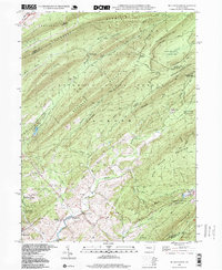 1998 Mc Alevys Fort1999 Print · USGSThe rural crossroads of Huntingdon County are preserved here in the late twentieth century, centered on the valley floor between the high ridges of Tussey Mountain and Broad Mountain. Researchers can locate family landmarks like the Jackson-Miller Sch, St Stephens Ch, and the historical settlement of McAlevys Fort.
 - 1998 Map of Coburn, 1999 Print
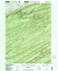 1998 Coburn1999 Print · USGSIn the late 1990s, the village of Coburn remained a quiet hub at the confluence of the valley's major creeks and the Penn Central rail line. Genealogists and hikers can trace the mountain landscape of the Bald Eagle State Forest, locating St Johns Ch and the secluded Salem Cem.
 - 1998 Map of Barrville, 1999 Print
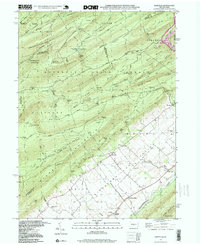 1998 Barrville1999 Print · USGSThe Kishacoquillas Valley and the mountain ridges of central Pennsylvania are shown here in the late 1990s as a landscape of agricultural tradition and vast state forests. Genealogists and researchers can trace rural life through the Barrville Sch, Long Lane Cem, and the old settlement at Kishacoquillas.
 - 1998 Map of Spring Mills, 1999 Print
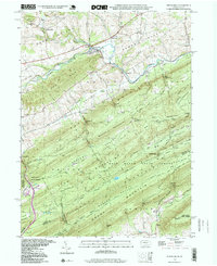 1998 Spring Mills1999 Print · USGSCentral Pennsylvania’s Ridge-and-Valley region is captured here in the late nineties, showcasing the tight-knit rural communities of Spring Mills and Potters Mills. Genealogists can locate family sites at Union Cem or Heckman Cem and trace the winding paths of Penns Creek through the forest gaps.
 - 1998 Map of Centre Hall, 1999 Print
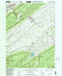 1998 Centre Hall1999 Print · USGSPenns Valley in the late twentieth century maintains its rural character between the dramatic ridges of Bald Eagle and Tussey Mountain. Trace family roots and local history at Egg Hill Cem, Emanuels Ch, and the crossroads at Potters Mills.
End of results
Showing maps 1-5 of 5
Top cities of Mifflin County
- Lewistown historical maps
- Granville Township historical maps
- Decatur Township historical maps
- Burnham historical maps
- Menno Township historical maps
- Juniata Terrace historical maps
See more
Frequently asked questions
- What are the different types of historical maps available for Mifflin County?
- What is the oldest map of Mifflin County?
- Where can I purchase historical maps of Mifflin County for my home or office?
- Where can I download high-res historical maps of Mifflin County?
- Are there historical topographic maps available for Mifflin County?
- Is there historical aerial imagery available for Mifflin County?
- Where are historical maps of Mifflin County sourced from?