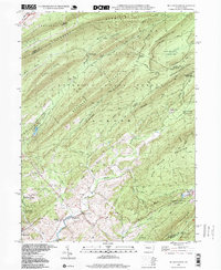
1998 Map of Mc Alevys Fort
USGS Topo · Published 1999About this map
McAlevys Fort and the nearby hamlet of Ennisville anchor this portion of the Pennsylvania ridge-and-valley province, where human settlement is concentrated along the floor of the Stone Creek valley. The map reveals a landscape deeply committed to forest research and conservation, notably featuring the PA State University Experimental Forest and several protected zones like the Alan Seeger Natural Area and Bear Meadows Natural Area. These areas are bounded by the massive elevations of Tussey Mountain and Broad Mountain.
Find a feature on this map
67 named features on this map. Tap any name to fly to it.
Don’t see what you’re looking for? This feature index may not catch every label — zoom into the map to look around manually.
Map Details
Editions of this 1998 Mc Alevys Fort Map
This is the sole edition of this map. No revisions or reprints were ever made.
Other maps of this area

1908 · Bellefonte
USGS Topo · 1:62,500

1909 · Bellefonte
USGS Topo · 1:62,500

1919 · Menno
USGS Topo · 1:62,500

1924 · Centre Hall
USGS Topo · 1:62,500

1924 · Lewistown
USGS Topo · 1:62,500

1927 · Lewisburg
USGS Topo · 1:62,500

1929 · Centre Hall
USGS Topo · 1:62,500

1935 · Allensville
USGS Topo · 1:62,500

1938 · Allensville
USGS Topo · 1:62,500

1943 · Lewistown
USGS Topo · 1:125,000
Featured Places
- Jackson Township, PA
- Harris Township, PA
- McAlevys Fort, Jackson Township
- Ferguson Township, PA
- Barree Township, PA