
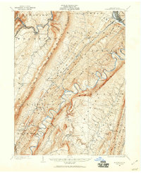
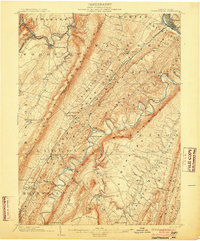
1943 Map of Lewistown
USGS Topo · Published 1943About this map
Bald Eagle Creek and the Juniata River carve a distinct industrial and agricultural landscape through Central Pennsylvania as seen in this 1943 survey. The rail network of the Pennsylvania Railroad anchors major hubs like Bellefonte and Lewistown, with critical junctions and spurs such as Mattern Junction and Snowshoe Intersection facilitating the region's transport. In the shadow of Nittany Mountain, State College appears as a burgeoning center of education and research, while the surrounding valleys are dotted with namesake rural institutions like the McNitt School and Emma Chapel. The map reveals the intricate water-and-mountain geography that dictated settlement patterns, from the remote The Barrens to the tight passage of the Lewistown Narrows. Local landmarks such as the Bellefonte Fish Hatchery and Penn Cave highlight the early recreational and natural features that defined the community's identity during the war years.
Find a feature on this map
245 named features on this map. Tap any name to fly to it.
Don’t see what you’re looking for? This feature index may not catch every label — zoom into the map to look around manually.
Map Details
Editions of this 1943 Lewistown Map
This is the sole edition of this map. No revisions or reprints were ever made.
Other maps of this area
1901 · Huntingdon
USGS Topo · 1:62,500
1904 · Huntingdon
USGS Topo · 1:62,500

1908 · Bellefonte
USGS Topo · 1:62,500

1909 · Bellefonte
USGS Topo · 1:62,500

1919 · Mattawana
USGS Topo · 1:62,500

1919 · Menno
USGS Topo · 1:62,500

1921 · Howard
USGS Topo · 1:48,000

1921 · Lock Haven
USGS Topo · 1:62,500

1922 · Mt Union
USGS Topo · 1:48,000

1922 · Philipsburg
USGS Topo · 1:62,500