1990s Maps of Monroe County, Pennsylvania
Explore 37 historic maps of Monroe County from the 1990s. These maps offer a rare glimpse into what life looked like during the 1990s — showing old roads, neighborhoods, homes, and landmarks that have changed or disappeared over time.
Whether you're researching your family's past, planning a metal detecting trip, or studying how Monroe County's landscape evolved across the 1990s, these high-resolution maps are a powerful tool for exploring the history of this region.
- Focus on a specific era: All maps on this page are from the 1990s, giving you a focused view of this time period.
- See what’s changed: Compare century-old streets, trails, and buildings to today's modern landscape using overlays and satellite layers.
- Research with precision: Use these maps for genealogy, historical research, land use analysis, or educational projects.
- View, download, or print: Maps are fully viewable online in high resolution, and can be downloaded or printed for your own records.
Start exploring Monroe County's history through authentic maps from the 1990s. This is your window into the past.
Monroe County, PA maps
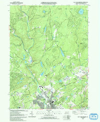
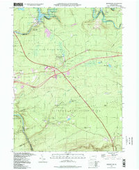
(37)- 1992 Map of Blakeslee, 1995 Print
 1992 Blakeslee1995 Print · USGSMonroe and Carbon counties are shown in the early nineties as the region's resort and racing identity was firmly set. Genealogists and historians can trace Blakeslee and Albrightsville, or locate landmarks like Pilgrim Ch and the Pocono International Raceway.
 - 1992 Map of Pleasant View Summit, 1995 Print
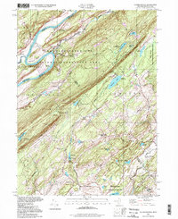
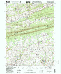
 1992 Pleasant View Summit1995 Print · USGSThe high plateau of the Poconos in the 1990s reveals a landscape defined by state forests and historic watercourses. Genealogists and hikers can trace the Bear Creek Railroad Grade or locate old sites near Stoddartsville and Shades Glen.
 - 1992 Map of Portland, 1995 Print
 1992 Portland1995 Print · USGSThe Delaware River gorge and Kittatinny ridgeline define this borderland during the late twentieth century. Researchers can trace the legacy of river industry and transport through the Old Railroad Grade, old rural burials at Fairview Cem, and the quiet Vail Sch.
 - 1992 Map of Stroudsburg, 1995 Print
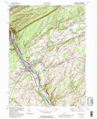
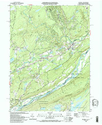
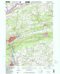
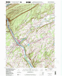
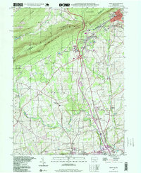
 1992 Stroudsburg1995 Print · USGSStroudsburg and the Delaware Water Gap are shown in the early nineties, capturing the intersection of growing Pocono boroughs and protected parklands. Genealogists can locate family sites at Stroudsburg Cem or trace the routes of the Appalachian Trail through Cherry Valley.
 - 1992 Map of Hickory Run, 1995 Print
 1992 Hickory Run1995 Print · USGSThe Poconos region in the early nineties reveals a landscape where major transportation corridors like the Northeast Extension meet vast state-managed woodlands. Genealogists and researchers can trace the vicinity of Leonardsville or East Side and explore the rugged geology of Boulder Field.
 - 1992 Map of Flatbrookville, 1995 Print
 1992 Flatbrookville1995 Print · USGSThe Delaware River valley and Kittatinny Ridge are shown here during the late twentieth century. Genealogists and local historians can locate old crossroads like Donkeys Corners and Egypt Mills, or trace the path of the Appalachian Trail.
 - 1992 Map of Kunkletown, 1995 Print
 1992 Kunkletown1995 Print · USGSNorthampton and Monroe counties are shown in the 1990s as rural communities nestled against the Blue Mountain ridge. Trace ancestral roots through Salem Ch, find the old Township Sch, or locate former extraction sites like the Quarries and Claypits.
 - 1993 Map of East Stroudsburg
 1993 East Stroudsburg1993 Print · USGSThe Pennsylvania Poconos in the early nineties show a landscape of growing mountain communities and secluded lakes. Genealogists can trace family names at Mt Zion Ch or explore the streets of East Stroudsburg and the settlement at Analomink.
 - 1993 Map of Bushkill
 1993 Bushkill1993 Print · USGSThe Delaware River valley in the early nineties reveals a landscape of protected recreation and rural mountain life. Genealogists and hikers can trace the Appalachian Trail across Kittatinny Mountain or find old community centers like St Johns Ch and Middle Smithfield Sch.
 - 1994 Map of Skytop, 1995 Print
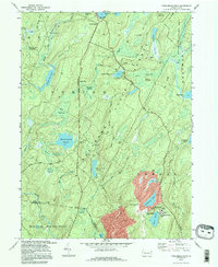
 1994 Skytop1995 Print · USGSMonroe and Pike Counties were centers for forest recreation and mountain retreats in the mid-1990s. Researchers can trace old woods roads and find family landmarks like the McComas Cem and early camp sites at Lake Lenape or Otter Lake.
 - 1994 Map of Promised Land, 1995 Print
 1994 Promised Land1995 Print · USGSPike County was a center for public conservation and wilderness recreation in the mid-1990s. Genealogists and hikers can trace the roads around Blooming Grove or locate landmarks like the Good Shepherd Ch and the Lookout Tower.
 - 1994 Map of Buck Hill Falls, 1995 Print
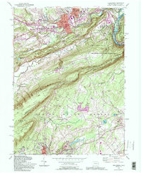
 1994 Buck Hill Falls1995 Print · USGSMonroe County was undergoing significant residential growth in the mid-1990s while maintaining its deep-rooted resort identity. Genealogists and local historians can trace family locations near Buck Hill Falls, Mountainhome, and St Anne Ch or locate landmarks like the Pocono Playhouse.
 - 1994 Map of Twelvemile Pond, 1996 Print
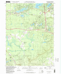
 1994 Twelvemile Pond1996 Print · USGSThe Pocono plateau in the mid-1990s reveals a landscape of dense wetlands and forest preserves managed by the state. Researchers can trace the layout of secluded settlements like Ludleyville and resort areas such as Tamiment and Unity House.
 - 1994 Map of Tobyhanna, 1996 Print
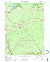
 1994 Tobyhanna1996 Print · USGSMonroe County was a hub of military logistics and Pocono recreation during the mid-nineties. Researchers can trace the layout of the Tobyhanna Army Depot, locate the Coolbaugh Sch, and explore the grounds of Camp Tegawitha.
 - 1997 Map of Pocono Pines, 1998 Print
 1997 Pocono Pines1998 Print · USGSMonroe County’s plateau transition into a residential and resort destination is fully visible in the late nineties. Researchers can trace the development of Lake Naomi Estates and find traces of earlier industry along the Old Railroad Grade and near Pocono Pines.
 - 1997 Map of Flatbrookville, 1998 Print
 1997 Flatbrookville1998 Print · USGSThe Delaware River corridor near the turn of the millennium remains a landscape of deep ridges and remote summer camps. Researchers can trace the winding Appalachian Trail or locate the Lower Wallpack Cem and the small hamlet of Flatbrookville.
 - 1997 Map of Promised Land, 1998 Print
 1997 Promised Land1998 Print · USGSThe Pocono Plateau comes into focus in the late nineties, showing a landscape of deep forests and glacial lakes. Genealogists and hikers can trace the foundations of Roemersville, the Blooming Grove Sch, and the shores of Bruce Lake.
 - 1997 Map of Thornhurst, 1998 Print
 1997 Thornhurst1998 Print · USGSThe Lehigh River valley and the Poconos plateau come into focus during the late nineties, showing a landscape shaped by conservation and seasonal recreation. Researchers can trace family sites at Clifton Cem or explore the wetlands of City of Rome Swamp and Bradys Lake.
 - 1997 Map of Hickory Run, 1998 Print
 1997 Hickory Run1998 Print · USGSCarbon County’s rugged Pocono plateau is defined here by protected lands and the Lehigh River corridor in the late nineties. Researchers can locate the sprawling Boulder Field, trace the old settlement at Leonardsville, or follow the Northeast Extension through Hickory Run State Park.
 - 1997 Map of Palmerton, 1999 Print
 1997 Palmerton1999 Print · USGSThe industrial corridor of the Lehigh Valley meets the ridgeline of the Appalachians in the late nineties. Researchers can trace the legacy of the Lehigh Canal and identify local landmarks like the Drive-in Theater, Bethany Tabernacle, and Slatington Airport.
 - 1997 Map of Portland, 1999 Print
 1997 Portland1999 Print · USGSThe Delaware Water Gap region at the close of the twentieth century shows a landscape defined by its river-and-rail corridor. Genealogists and historians can trace local roots at James Ch, St Vincent Cem, or the old riverside village of Portland.
 - 1997 Map of Wind Gap, 1999 Print
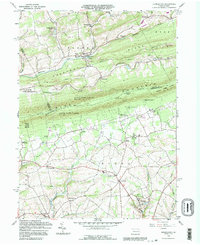
 1997 Wind Gap1999 Print · USGSThe Slate Belt of Northampton County meets the Blue Mountain ridge in the late nineties, showcasing a landscape of industry and nature. Trace the legacy of extraction and transit at the Pen Argyl Yards, numerous Quarries, and landmarks like the Mt View Park Racetrack.
 - 1997 Map of Pleasant View Summit, 1999 Print
 1997 Pleasant View Summit1999 Print · USGSThe Pocono plateau near the turn of the millennium remained a landscape of dense forests and river confluences. Genealogists and hikers can trace old routes like Tannery Road, locate the Lookout Tower on Big Pine Hill, and explore the riverside site of Stoddartsville.
 - 1997 Map of Kunkletown, 1999 Print
 1997 Kunkletown1999 Print · USGSNorthampton County at the end of the century reflects a landscape of ridge-top trails and deep-seated industrial roots. Genealogists and historians can trace the foundations of Kunkletown, family-named sites like Arndts, and local landmarks like Fairview Cem.
 - 1997 Map of Skytop, 2000 Print
 1997 Skytop2000 Print · USGSMonroe and Pike Counties are shown here during the late twentieth century, when this region of the Poconos was defined by its vast state forests and mountain retreats. Researchers can trace land use at Skytop, locate the McComas Cem, and find old camps like Camp William Penn.
Showing maps 1-25 of 37
Top cities of Monroe County
- East Stroudsburg historical maps
- Stroudsburg historical maps
- Mount Pocono historical maps
- Delaware Water Gap historical maps
Frequently asked questions
- What are the different types of historical maps available for Monroe County?
- What is the oldest map of Monroe County?
- Where can I purchase historical maps of Monroe County for my home or office?
- Where can I download high-res historical maps of Monroe County?
- Are there historical topographic maps available for Monroe County?
- Is there historical aerial imagery available for Monroe County?
- Where are historical maps of Monroe County sourced from?