1940s Maps of Monroe County, Pennsylvania
Explore 22 historic maps of Monroe County from the 1940s. These maps offer a rare glimpse into what life looked like during the 1940s — showing old roads, neighborhoods, homes, and landmarks that have changed or disappeared over time.
Whether you're researching your family's past, planning a metal detecting trip, or studying how Monroe County's landscape evolved across the 1940s, these high-resolution maps are a powerful tool for exploring the history of this region.
- Focus on a specific era: All maps on this page are from the 1940s, giving you a focused view of this time period.
- See what’s changed: Compare century-old streets, trails, and buildings to today's modern landscape using overlays and satellite layers.
- Research with precision: Use these maps for genealogy, historical research, land use analysis, or educational projects.
- View, download, or print: Maps are fully viewable online in high resolution, and can be downloaded or printed for your own records.
Start exploring Monroe County's history through authentic maps from the 1940s. This is your window into the past.
Monroe County, PA maps
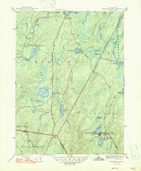
(22)- 1941 Map of Delaware Water Gap
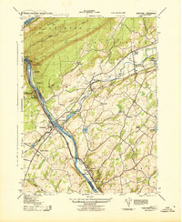
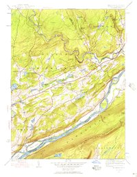
 1941 Delaware Water Gap1941 Print · USGSThe Delaware River valley is captured here in the early 1940s, showing the borderlands of Pennsylvania and New Jersey. Genealogists can trace family names through dozens of rural landmarks like Three Church Hill, Brass Castle, and the Stone Church PO.
 - 1942 Map of Delaware Water Gap
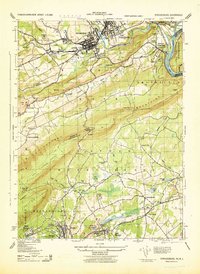
 1942 Delaware Water Gap1942 Print · USGSThe Delaware River gorge and its surrounding ridges come into focus during the early war years, highlighting a critical rail and river junction. Trace local history through family-named landmarks like Miller Ch, rural Quaker Plain Sch, and the unique name of Manunka Chunk.3 unique versions available
 - 1943 Map of Bushkill
 1943 Bushkill1943 Print · USGSMonroe County and the Delaware River valley are captured in the early 1940s during a time of rural persistence and local industry. Genealogists and historians can locate family landmarks like Dimicks Ferry, St Thomas Chapel, and the vanished sites of Craig Meadows.2 unique versions available
 - 1943 Map of Portland
 1943 Portland1943 Print · USGSThe Delaware River valley was a bustling corridor of rail and river transit during the early years of the Second World War. Researchers can trace the paths of several major railroads, locate family sites like the Fairview Cemetery, and find old infrastructure such as the Myers Ferry and Hainesburg RR Sta.2 unique versions available
 - 1943 Map of Scranton
 1943 Scranton1943 Print · USGSNortheastern Pennsylvania’s coal and rail corridor comes to life in the 1940s, showcasing the dense urban industrial centers of the Wyoming Valley. Genealogists can locate family landmarks like the Fayette School and Locust Ridge School or trace the early paths of the DL & W and Erie railroads.
 - 1943 Map of Mauch Chunk
 1943 Mauch Chunk1943 Print · USGSThe Lehigh River corridor is captured here during the mid-forties, showing the vital rail and industry centers of Carbon County. Genealogists and researchers can trace dozens of rural schoolhouses and family-named landmarks like the Larrytown Poor Farm, St Pauls Ch, and Three O'clock Spring.
 - 1943 Map of Wind Gap
 1943 Wind Gap1943 Print · USGSThe Pennsylvania countryside near the Monroe and Northampton county line is captured here during the wartime era. Researchers can trace the path of the Lehigh and New England railroad through the Wind Gap pass or locate local landmarks like St Joseph Sch and Ross Common.
 - 1943 Map of Stoddartsville
 1943 Stoddartsville1943 Print · USGSThe Pocono Plateau at the height of the Second World War shows a landscape defined by river valleys and developing recreation preserves. Genealogists and local historians can trace rural schoolhouses and small settlements like Stoddartsville, Albrightsville, and the Fishery Sch.
 - 1943 Map of Pocono
 1943 Pocono1943 Print · USGSMonroe County was a well-established retreat and transportation hub in the early 1940s, centered around the Delaware Lackawanna and Western railroad. Researchers can trace old mountain roads and family-named landmarks like Camelback Mountain, Naomi Pines Sch, and the Mount Pocono Airport.
 - 1943 Map of Bethlehem
 1943 Bethlehem1943 Print · USGSNorthampton and Lehigh counties hummed with industry and river commerce during the early war years. Researchers can trace the path of the Lehigh Valley RR, locate family-named landmarks like Chief Tatamy, and find rural schools such as Mexico School and Poplar Valley Sch.
 - 1943 Map of Flatbrookville
 1943 Flatbrookville1943 Print · USGSThe Delaware River borderlands are captured here during the 1940s, showing a landscape of mountain ridges and riverside ferry crossings. Genealogists can locate old homesteads and landmarks like Wintermutes Foundry, Newbakers Corners, and Stillwater TWS School.
 - 1943 Map of Stroudsburg, 1944 Print
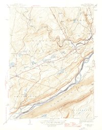
 1943 Stroudsburg1944 Print · USGSThe Poconos and the Delaware Water Gap are captured here during the wartime era, showing a mix of industrial centers and mountain terrain. Researchers can trace the rail lines serving Slate Quarries or find local landmarks like Temple Israel and Mammoth Hosiery Mills.
 - 1943 Map of Twelvemile Pond, 1956 Print
 1943 Twelvemile Pond1956 Print · USGSPike County in the 1940s was a landscape of dense woodlands and seasonal retreats at the intersection of several townships. Researchers can trace the footprints of local social life at the Hunters Range Sch and private institutions like the Beaver Run Club and Camp Tamiment.6 unique versions available
 - 1943 Map of Skytop, 1956 Print
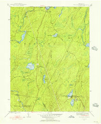
 1943 Skytop1956 Print · USGSMonroe County in the early 1940s is shown as a landscape of remote mountain camps and private clubs. Genealogists and historians can trace family locations near McComas Chapel, Skytop, and the numerous seasonal sites like Camp Canadensis and Camp Girard.4 unique versions available
 - 1944 Map of Bushkill, 1956 Print
 1944 Bushkill1956 Print · USGSThe Delaware Water Gap region is seen here during the mid-1940s, just as the mountain landscape was becoming a premier recreation destination. Genealogists and hikers can trace old river crossings like Dimicks Ferry and landmark sites such as Bushkill Falls and Sand Hill Ch Cem.7 unique versions available
 - 1944 Map of East Stroudsburg, 1956 Print
 1944 East Stroudsburg1956 Print · USGSEast Stroudsburg and the surrounding Pocono townships are captured here in the mid-1940s, a landscape defined by the winding Brodhead Creek and the busy Delaware Lackawanna and Western rail line. Researchers can trace rural landmarks from Lesoine Sch to the Franklin Hill Cem and the early Pipher Airport.6 unique versions available
 - 1944 Map of Newark, 1971 Print
 1944 Newark1971 Print · USGSThe industrial corridor from Philadelphia to New York was in a period of massive transition during the mid-forties. Genealogists and researchers can trace the rail lines of the Lehigh Valley RR, locate military installations like Picatinny Arsenal, and explore the early sprawl near Levittown.5 unique versions available
 - 1947 Map of East Stroudsburg
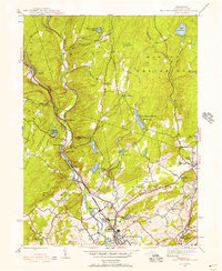
 1947 East Stroudsburg1947 Print · USGSThe Pocono foothills around the time of the post-war boom reveal a network of mountain villages and valley creeks. Genealogists and local historians can locate rural landmarks like Beakleyville Ch, the Boise Sch, and the Pipher Airport.2 unique versions available
 - 1947 Map of Bushkill
 1947 Bushkill1947 Print · USGSThe Delaware River valley in the mid-1940s reveals a landscape of river-crossing points and upland ridges before the major changes of the later century. Trace local family roots at Dimicks Ferry, Middle Smithfield Sch, or the small settlement of Shoemakers.2 unique versions available
 - 1947 Map of Skytop
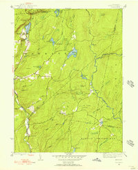
 1947 Skytop1947 Print · USGSThe high Poconos were transitioning into a major recreational hub after the war, centered around private clubs and summer camps. Genealogists and historians can locate family landmarks like McComas Chapel or trace the early boundaries of Camp Girard and the Hiawatha Club.2 unique versions available
 - 1947 Map of Twelvemile Pond
 1947 Twelvemile Pond1947 Print · USGSPike County was a landscape of sporting clubs and high wetlands in the years following the war. Genealogists and historians can locate the Hunters Range Sch, trace the Old Shohola Road, and explore the grounds of Camp Taminiment and Sandyville.2 unique versions available
 - 1949 Map of Newark
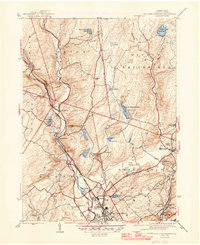
 1949 Newark1949 Print · USGSThe industrial corridor between Philadelphia and New York comes alive in this post-war survey. Genealogists and historians can trace the massive rail networks of the Reading Railroad and locate major installations like Fort Dix or Picatinny Arsenal.2 unique versions available
End of results
Showing maps 1-22 of 22
Top cities of Monroe County
- East Stroudsburg historical maps
- Stroudsburg historical maps
- Mount Pocono historical maps
- Delaware Water Gap historical maps
Frequently asked questions
- What are the different types of historical maps available for Monroe County?
- What is the oldest map of Monroe County?
- Where can I purchase historical maps of Monroe County for my home or office?
- Where can I download high-res historical maps of Monroe County?
- Are there historical topographic maps available for Monroe County?
- Is there historical aerial imagery available for Monroe County?
- Where are historical maps of Monroe County sourced from?